
Bathurst Bay
On the night of 4 March 1899, the barometer at Bathurst Bay fell further than anyone aboard the pearling fleet had ever seen. Hundreds of small wooden luggers and a handful of schooners lay at anchor here, riding out what the crews assumed would be another blow. It was not another blow. By morning, more than half the fleet was gone, the forests along the shore were dead, and somewhere between three and four hundred people had drowned. Cyclone Mahina remains the deadliest cyclone in recorded Australian history, and this still, ordinary-looking bay below Cape Melville is where it came ashore.
The People of the Pearl
Bathurst Bay was never much of a settlement. Its climate and terrain offered little to trade, and by the 1890s only one thing kept people coming: pearl shell. The fleet that anchored here each season was a floating community of the colonial Pacific - Pacific Islander divers, Japanese crews, Aboriginal men and women, and others drawn into one of the era's most dangerous industries. When Mahina struck, roughly a thousand men, women and children were aboard the boats in the Bathurst Bay and Princess Charlotte Bay anchorage, waiting to offload shell. They had families, names and homes scattered across the islands and coasts of the region. Most of them would not be counted. The Queensland registry recorded 283 deaths, including 250 on the pearling ships, but the true toll was higher - one fleet owner alone reckoned thirty of his crew were never registered at all.
The Wave
What made Mahina lethal was not only the wind. The storm drove an enormous surge of seawater ahead of it, and Constable J.M. Kenny, camped on a ridge at Barrow Point south of Cape Melville, reported water sweeping over his camp high above the beach and reaching some five kilometres inland. Contemporary accounts spoke of a surge perhaps thirteen metres high - a figure scientists still debate, with recent work suggesting a more modest but still catastrophic three to five metres. Whatever its exact height, it was among the greatest storm surges ever recorded. It tore the fleet from its anchors in the dark, swept the settlement away, and salted the land so deeply that the once-abundant coastal forests have never fully grown back.
Those the Sea Took Onshore
This was the country of the Mutumui and Walmbaria peoples, and the cyclone did not spare those on land. More than a hundred Aboriginal people are believed to have died here - some in the flooded forest country, and some, accounts suggest, while trying to help shipwrecked sailors, caught when the back-surge dragged them into the sea. For decades their loss was barely acknowledged. The memorial raised at Cape Melville in 1899 carved the names of nine Europeans in full; beneath them, a single line recorded that "300 coloured men also drowned" - the language of the era, reducing hundreds of Islander, Asian and Aboriginal lives to one anonymous sentence. In 2015, after years of research and advocacy, descendants and supporters at last named the First Nations dead, returning some measure of identity to people history had left in a margin.
What the Bay Holds Now
Today Bathurst Bay is quiet again - a remote corner of Cape York within sight of the Great Barrier Reef, visited mostly by anglers and the occasional traveller working their way out to Cape Melville's granite. Few people live here. The fishing is good and the water, on a calm day, gives no hint of what it once did. But the bay is not an empty postcard. It is one of the most consequential disaster sites in the country, a place where more than three hundred people - Islander, Japanese, Aboriginal and European - lost their lives in a single night, and where the long, slow work of remembering all of them properly is only now being done.
From the Air
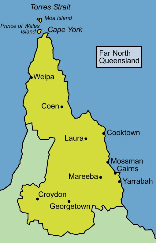
Bathurst Bay sits at approximately 14.25°S, 144.38°E on the east coast of Cape York Peninsula, just southwest of the Cape Melville headland and forming part of the larger Princess Charlotte Bay system. From the air it is a broad, shallow embayment fringed by sand beaches, mangroves and the distinctive tumbled granite of the Melville Range to the east. Recommended viewing altitude 6,000-10,000 ft; the surrounding reefs and the granite mass of Cape Melville are the key visual references. This coast lies squarely in the tropical cyclone belt - the season runs roughly November to April, and Cyclone Mahina came ashore here in March 1899; expect deteriorating conditions in the wet season. Nearest airfields: Cooktown (YCKN) to the south, Coen (YCOE) inland; Cairns (YBCS / CNS) is the major gateway some 350 km south-southeast. Remote terrain, no services - carry full reserves.
Nearby Stories
- Musgrave Telegraph Station 39 km away
- Coen, Queensland 65 km away
- Mrs Watson's Cottage 67 km away
- Lizard Island 77 km away
- Coen Carrier Station 77 km away
- Old Laura Homestead 85 km away
- Lockhart River, Queensland 177 km away
- Japanese submarine Ro-33 554 km away