
Battle of Droop Mountain
By the time the cannon smoke cleared on the afternoon of November 6, 1863, the Confederacy had effectively lost West Virginia. Droop Mountain rises 3,100 feet above the Greenbrier Valley in Pocahontas County, a long whaleback of sandstone with a view that lets you see, on a clear day, the next ridge and the one after that. For one cold afternoon in the autumn after Gettysburg, this mountain hosted the largest battle ever fought within the borders of the brand-new state of West Virginia. The fight was over by sundown. The strategic consequence lasted to the end of the war.
Why Here, Why Then
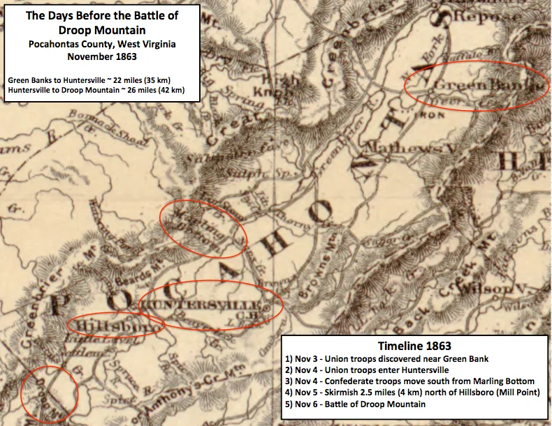
West Virginia had been a state for less than five months. The Confederates still considered it Virginia and still believed they might reclaim it. Brigadier General William W. Averell, leading a Union mixed force of cavalry and mounted infantry out of the Kanawha Valley, was pushing southeast through the mountains toward the Virginia and Tennessee Railroad - the supply artery the Confederacy could not afford to lose. Brigadier General John Echols and Colonel William L. Jackson commanded the Confederate forces sent to stop him. They chose Droop Mountain because the road from Hillsboro to Lewisburg crossed its summit, because the mountain was steep enough to make a frontal attack suicide, and because there was nowhere else to make a stand in time.
The Numbers
On the morning of the battle, Jackson had about 750 men on the summit. Echols arrived with reinforcements around 9 a.m., bringing the total Confederate force to roughly 1,700 - mostly dismounted cavalry, plus the 22nd Virginia Infantry and a battalion that history would remember as Derrick's. Averell brought about 4,000. The numerical mismatch was decisive but not instantly so. Confederate artillery on the high ground outranged and outshot the Union batteries below, and for hours the cannons did most of the talking. The mountain echoed with the heavy concussion of 12-pound howitzers, the smaller crack of rifles, and the long pause between volleys when men reloaded by hand. Lieutenant Joseph Daniels of Keepers Battery was killed by a Confederate shell while standing next to Colonel Schoonmaker. The shell took off his head.
The Flanking March
Averell had been a soldier long enough to know that uphill frontal assaults against entrenched infantry end one way. He sent Colonel Augustus Moor and 1,175 men - the 10th West Virginia Infantry, the 28th Ohio Infantry, and supporting cavalry - on a long circuitous march around the Confederate left. Six to nine miles, depending on which Civil War historian you ask, through dense second-growth forest on a route that Moor could only guess at. The Confederates did not see them coming. When Moor's force emerged on Jackson's left flank in early afternoon, the Confederate line bent, then broke. Echols shifted men to plug the gap. Reinforcements arrived. Casualties mounted. Then Averell ordered the frontal attack.
The Breastworks
The Confederate center was held by dismounted cavalry behind log and stone breastworks - the 14th Virginia under Colonel Cochran, the 20th Virginia under Colonel Arnett. When the Union regiments reached the top of the mountain, the fight became hand-to-hand. Confederate soldiers, out of ammunition, swung their empty muskets like clubs. Union soldiers crouched behind the breastworks and shoved their pistols over the top, firing blindly into the men crouched on the other side. The 2nd West Virginia Mounted Infantry took the heaviest casualties of the assaulting regiments and was the first into the works. By late afternoon the Confederate line dissolved. Echols ordered a retreat that quickly became a rout. The Confederates fell back toward Lewisburg, leaving their dead and most of their wounded on the mountain.
What It Meant
Droop Mountain was the largest Civil War engagement fought entirely within West Virginia, but in the national memory of the war it is barely a footnote. It came four months after Gettysburg, two weeks before Lincoln would travel to Gettysburg to dedicate the cemetery, in a state that had only just been created. It produced no famous generals and changed no major campaign. But it accomplished what Averell came to do: the Confederacy never again mounted a serious effort to retake the Greenbrier Valley. The battlefield itself became a state park in 1928, one of the first Civil War battlefields preserved in West Virginia. The earthworks the Virginians threw up that November morning are still visible. The view from the summit is the same view Jackson had when he counted the campfires of the army marching to break him.
From the Air
Located at 38.11 degrees N, 80.27 degrees W in Pocahontas County, West Virginia. Droop Mountain rises to 3,100 feet MSL above the Greenbrier Valley. The battlefield sits on US-219 about 24 nm north of Lewisburg. Greenbrier Valley Airport (KLWB) is the nearest tower-controlled field. Marlinton Airport (KMRT) is a small uncontrolled strip about 18 nm north. Recommended viewing altitude 5,500 to 7,500 feet MSL. Expect mountain wave turbulence with westerly winds; the long north-south ridges of the Allegheny Plateau are visible to the east and west.
Nearby Stories
- Warm Springs Pools 2.1 km away
- The Greenbrier 2.2 km away
- Appalachian String Band Music Festival 11 km away
- Battle of Camp Allegheny 19 km away
- Webster Sycamore 22 km away
- Clay, West Virginia 25 km away
- Botetourt County, Virginia 27 km away
- Beckley, West Virginia 29 km away