.jpg)
The Sultan's Island at the River's Mouth
According to local legend, the warrior Awang Semaun was playing gasing -- a Malay spinning top game -- with his nephew near Bukit Patoi in Temburong when his top collided mid-spin, launched itself across the sky toward the Brunei River, bounced off the water like a skipping stone, and landed upside-down on the shore of Berambang Island. It spun there until it turned to rock. The boulder supposedly remains. Whether or not you believe in petrified spinning tops, Berambang Island has always been a place where improbable things converge: sultans and coal miners, mangrove ecologists and proboscis monkeys, all sharing 1,939 hectares of river island at the mouth of the Brunei River.
A Palace at the River's Gate
Sultan Muhammad Hasan chose the island's northernmost point, Tanjong Kindana, for his palace -- a strategic position commanding the entrance to the Brunei River. From there, he built a covered passageway to neighboring Chermin Island, which served as a fortified defensive stronghold. It was a ruler's calculation: live where you can see everything coming, and keep your retreat behind a bridge you can destroy. During his reign, or possibly that of his successor Sultan Abdul Jalilul Akbar, the Spanish Empire sent an envoy to Brunei, likely navigating past the very point where the palace stood. After Sultan Hasan's death in 1598, he was interred in a mausoleum at Kampong Sungai Bunga on the island. The mausoleum still stands, one of the oldest royal burial sites in Brunei.
Coal, Oil, and the White Rajah
Centuries later, Berambang Island caught the attention of a different kind of power. Sir Charles Brooke, the second Rajah of Sarawak, occupied the island -- known locally as Buang Tawer -- and began mining coal at the foot of its hills. What his miners found in 1902, however, was more interesting than coal: crude oil, seeping from the ground near Buang Tawar. Production was modest -- 5,433 gallons by 1911, declining to 3,320 gallons by 1924 -- but the oil fueled the Brooketon and Sadong Coal Mining Company's operations in Muara. When the coal operation wound down, the blockhouse Brooke had built was dismantled piece by piece, its timbers repurposed into offices, a police station, and barracks in Muara. A 1915 colonial report notes the recycling with bureaucratic matter-of-factness, as if buildings migrated between islands routinely.
Where Proboscis Monkeys Still Have Room
The island's mangroves are not a backdrop. They are the reason Berambang matters ecologically. The western coast is dominated by Heritiera globosa and nipa palms, while the eastern shore hosts Rhizophora species and Avicennia stands near Sungai Manunggol. Together, these forests serve as breeding grounds for fish and crustaceans that sustain Brunei's fishing industry. They also provide one of the last undisturbed habitats for the proboscis monkey, a species found only on Borneo, whose bulbous nose and pot belly make it unmistakable and whose survival depends on exactly the kind of continuous mangrove forest Berambang still offers. In 1978, the island was designated a wildlife sanctuary under the Wildlife Protection Act. Three villages -- Kampong Riong, Kampong Pudak, and Kampong Tanjong Kindana -- were identified as sanctuary zones. In 1982, the Ministry of Development proposed protecting 721 hectares of the island's mangroves as a formal conservation area, a recommendation later reinforced by biologists at Universiti Brunei Darussalam.
Six Villages on a Living Island
Berambang is not a wilderness. Six kampongs dot the island: Berambang, Menunggol, Riong, Sungai Bunga, Pudak, and Bolkiah 'B.' The northern side has grown steadily more concrete since the early 2000s, and a B$181.5 million housing scheme under the 2001-2005 National Development Plan included expansion at Kampong Sungai Bunga. But the island's economy still leans on the water. Brunei's first commercial fish cage farm started operations here in the early 1990s, and Kampong Sungai Bunga has built a small tourism economy around its Seri Tanjung Homestay, where visitors sleep in affordable waterside accommodations and learn the rhythms of traditional seafood production. The homestay earned the ASEAN Homestay Standard award in 2016. Beneath Bukit Kindana, the island's 157-meter hill crowned by a distinctive cluster of trees, the old tensions persist: development on one side, mangrove sanctuary on the other, and 575 hectares of grey, clayey, acid-sulfate soil that floods with every high spring tide -- reminding everyone that the island's schedule belongs to the river, not the planners.
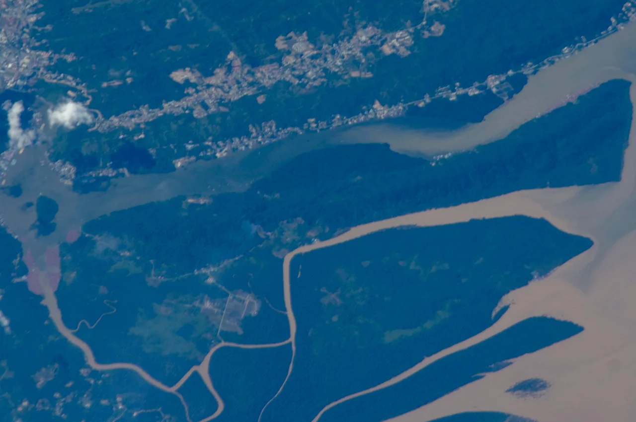
From the Air
Located at 4.87N, 114.98E in the Brunei River, Brunei-Muara District. Berambang is clearly visible as the largest island in the river, with Bukit Kindana (157 m) as a prominent forested hill on the north end. The island lies east of the mainland, south of Brunei Bay. Nearest airport: Brunei International Airport (WBSB), approximately 15 km northwest. Recommended viewing altitude: 3,000-6,000 ft for island overview; lower for mangrove detail. Look for the contrast between developed northern shore and mangrove-covered southern areas. Tropical climate; hazy conditions possible during burning season.
Nearby Stories
- Where the River Meets the Sea 6.6 km away
- USS Salute: The Minesweeper That Found the Last Mine 7.2 km away
- The Green Jewel You Can Only Reach by River 13 km away
- The Dragon's Lake 16 km away
- Sabah State Railway 29 km away
- Starcevich Monument 57 km away
- Raid on Kalabakan 203 km away
- Luconia Shoals 245 km away