The Forests That Burn Underground
The fire travels underground. That is the fact that makes Borneo's peat swamp forests unlike any other burning landscape on Earth. Dried-out peat ignites easily enough on the surface, but then it descends, smoldering through meters of compressed organic matter, crawling invisibly beneath the ground to erupt in locations no one predicted. During the catastrophic fires of 1997-1998, driven by El Nino drought and accelerated by Indonesia's Mega Rice Project, these subterranean blazes released between 0.81 and 2.57 gigatons of carbon into the atmosphere -- equivalent to 13 to 40 percent of the entire world's annual fossil fuel emissions. The largest single-year spike in atmospheric CO2 since records began in 1957 was not caused by cars or factories. It was caused, in significant part, by the burning of ancient swamp.
Twenty Meters of Accumulated Time
Peat swamp forests form where waterlogged soil prevents dead vegetation from fully decomposing. Leaves fall, branches snap, trees topple -- and instead of rotting, this organic material compresses into thick, acidic beds of peat that can reach 20 meters deep, with pH levels as low as 2.9. The water that pools among the trees is stained dark brown by tannins leaching from the peat, giving these ecosystems their local name: blackwater swamps. On Borneo, peat swamp forests occupy the coastal lowlands of Indonesian Kalimantan, Malaysian Sarawak, and Brunei's Belait District, built up behind brackish mangrove zones and bounded by better-drained lowland rainforest. Most are geologically young, less than 5,000 years old, but the peat itself is a carbon archive -- each meter representing centuries of stored atmospheric carbon. About 62 percent of the world's tropical peatlands lie in the Indo-Malayan region, with Indonesia alone holding 80 percent.
Seventy-Meter Giants in Spongy Ground
These are not the bleak, mossy bogs of northern Europe. Borneo's peat swamp forests support trees up to 70 meters tall, rooted in substrate so spongy and unstable that they require buttresses, stilt roots, and pneumatophores just to stay upright. Despite the extreme acidity and low nutrients, 927 species of flowering plants and ferns have been recorded in these forests -- more than three times the 260 species found in a comparable study in Peninsular Malaysia. The vegetation arranges itself in concentric circles from swamp center to fringe, with species composition shifting as water depth and peat chemistry change. Many of the tree families are shared with the surrounding dipterocarp forests, but numerous species are found nowhere else. Root mats concentrate in the upper 50 centimeters of peat, where the trees can access what little oxygen and nutrients the waterlogged ground offers. Protected areas shelter fragments of this biodiversity: Tanjung Puting and Sabangau National Parks are the largest, alongside Brunei's Belait Peat Swamp and portions of parks spanning Sarawak and Kalimantan.
The Mega Rice Project and Its Aftermath
In the mid-1990s, the Indonesian government launched the Mega Rice Project, draining over one million hectares of peat swamp forest in Kalimantan for conversion to rice paddies. Between 1996 and 1998, workers dug more than 4,000 kilometers of drainage and irrigation channels. The plan backfired. Instead of irrigating the land, the channels drained the peat, dropping water tables and leaving the forest surface dry year-round where it had previously flooded two meters deep during the monsoon. Roads and railways built for legal forestry opened the region to illegal loggers who stripped nearly all marketable timber. Forest cover in the project area dropped from 64.8 percent in 1991 to 45.7 percent by 2000. The Indonesian government eventually abandoned the project, but the damage was structural: once drained, peat does not simply re-wet. The channels had turned a carbon sink into a fire hazard.
Smoke That Crossed Borders
When the drained peatlands caught fire during the El Nino droughts of 1997-1998 and again in 2002-2003, the consequences reached far beyond Borneo. Dense smoke and haze blanketed Southeast Asia for months, causing respiratory problems among half a million people. Satellite imagery from the European Space Agency showed the smoke plumes stretching across the South China Sea. Scientists calculated that 91.5 percent of the 790,000 hectares that burned in 1997 was peatland, not surface forest. The peat combustion alone released an estimated 0.19 to 0.23 gigatons of carbon, with another 0.05 gigatons from the vegetation above. Fire damaged nature reserves like Muara Kaman, destroyed new agricultural plantings alongside old forest, and killed uncounted birds, animals, and reptiles. The fires returned in 2006 and 2009, each time filling the skies with the acrid evidence of an ecosystem that, once destabilized, keeps burning. Indonesia became the world's third-largest carbon emitter, driven substantially by the destruction of forests that had been quietly storing carbon for millennia.
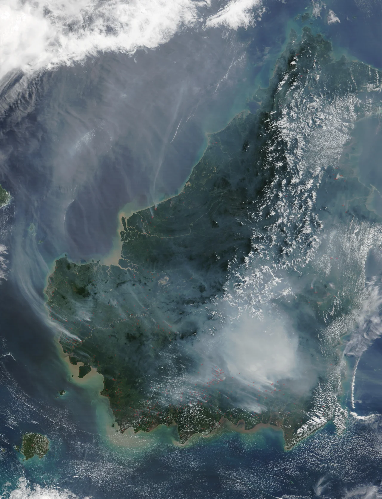
From the Air
Located at approximately 4.90N, 115.20E, spanning coastal lowlands of Borneo across Kalimantan (Indonesia), Sarawak (Malaysia), and Belait District (Brunei). From altitude, peat swamp areas appear as flat, dark-green expanses on coastal plains behind mangrove fringes. Burned and drained areas in Kalimantan show distinctive brown and grey patches. During burning season (typically August-October in El Nino years), visibility may be severely reduced by haze. Nearest airports: Brunei International (WBSB), Miri (WBGR), Kota Kinabalu (WBKK). Recommended viewing altitude: 10,000-20,000 ft for ecoregion overview. Protected areas like Tanjung Puting and Sabangau are visible as intact green zones surrounded by degraded land.
Nearby Stories
- Where the River Meets the Sea 6.6 km away
- USS Salute: The Minesweeper That Found the Last Mine 7.2 km away
- The Green Jewel You Can Only Reach by River 13 km away
- The Dragon's Lake 16 km away
- Sabah State Railway 29 km away
- Starcevich Monument 57 km away
- Raid on Kalabakan 203 km away
- Luconia Shoals 245 km away