
Boundaries of Hong Kong
For most of Hong Kong's colonial history, the border with China wasn't really a border at all. People moved across the Sham Chun River freely, following trade, family connections, and the rhythms of southern Chinese rural life. It wasn't until April 1949 — when the British authorities decided that the flood of refugees from the civil war on the mainland had to be managed — that the line became a line in the modern sense. The Chinese side closed formally by 1952. What had been a convenience became a threshold, and what was a threshold became, over the following seventy years, one of the most closely watched and legally complex borders in Asia.
Three Treaties, One Territory
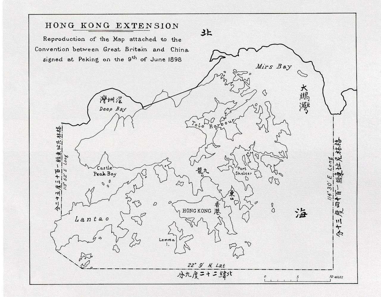
Hong Kong's territory was assembled through three separate agreements with the Qing dynasty. The first was the 1842 Treaty of Nanking, which ceded Hong Kong Island to Britain following the First Opium War. The second was the 1860 Convention of Peking, which added the Kowloon Peninsula south of what became Boundary Street. The third — and most consequential for the shape of modern Hong Kong — was the 1898 Convention for the Extension of Hong Kong Territory, which leased the New Territories to Britain for 99 years, with the Sham Chun River serving as the primary land boundary with Qing China.
The lease on the New Territories is why 1997 mattered. The ceded portions — Hong Kong Island and Kowloon — were technically British in perpetuity, but the New Territories (which by the late twentieth century contained most of Hong Kong's population and land area) were on a clock. The 1984 Sino-British Joint Declaration resolved the ambiguity: the entire territory, leased and ceded alike, would transfer to the People's Republic of China on 1 July 1997 under the principle of One Country, Two Systems.
The Years the Border Closed
Between 1941 and 1945, the borders of Hong Kong were effectively suspended. The Japanese occupation of Hong Kong coincided with Japanese control of adjacent southern China, so the boundary between them was an internal line within a single occupying power's territory rather than an international frontier.
After the 1945 surrender, the British restored all institutions, including the land boundary running across the Sham Chun River. The postwar years brought a different kind of pressure: the Chinese Civil War had driven hundreds of thousands of refugees toward Hong Kong. British authorities held the line as long as they could, but the scale of movement made controls unmanageable. The formal closure in April 1949 — with Chinese authorities mirroring the closure by 1952 — transformed a permeable colonial boundary into something more like a hard international border, requiring permits to cross.
The Shape of the Line Today
The current boundary consists of a 30-kilometre land border fence along the northern edge of the New Territories and a 733-kilometre maritime boundary encircling Hong Kong's coastline and territorial waters. The land border runs roughly east-west, with the Sham Chun River as its primary marker in the western section. The 1997 handover modified and extended the maritime boundary as defined by the Hong Kong Basic Law.
Thirteen immigration control points regulate movement across the boundary. These include multiple land crossings — among them the busy Lo Wu and Lok Ma Chau points and the Heung Yuen Wai crossing — as well as sea ferry terminals handling arrivals from Macau and mainland Chinese ports. Notable among them are the Hong Kong West Kowloon railway station, which handles high-speed rail arrivals from the mainland via co-location immigration clearance, and Hong Kong International Airport, which processes incoming passengers at its own immigration facilities.
A Constitutional Threshold
What makes Hong Kong's boundary unusual is not its physical character — the fence and river look like any managed border — but its legal and constitutional nature. Under One Country, Two Systems, the boundary separates two parts of the same sovereign state that operate under fundamentally different legal and economic frameworks. Hong Kong maintains its own currency, common law judicial system, and immigration policy distinct from mainland China.
The Basic Law, Hong Kong's constitutional document, specifies the boundary in legal terms. Crossing it in either direction triggers a shift in applicable law, currency, and the rights that apply to the person crossing. This has made the boundary a site of political significance well beyond its geography — the subject of legal challenges, policy debates, and international attention that a 30-kilometre fence might not otherwise attract. From the air, it is a line of infrastructure across the low hills of the New Territories. On the ground, it marks one of the world's most carefully maintained constitutional distinctions.
From the Air
The land border of Hong Kong runs east-west across the northern New Territories at approximately 22.49–22.55°N, with Hong Kong International Airport (VHHH) at 22.31°N, 113.91°E on Lantau Island to the southwest. From cruising altitude on approach from the north, the border fence and the urban density of Shenzhen immediately beyond are clearly visible, contrasting with the lower-density New Territories towns on the Hong Kong side. The Lo Wu crossing near 22.53°N, 114.11°E is a prominent infrastructure feature. Lantau Island, the airport, and Hong Kong Island's Peak are the primary visual landmarks.
Nearby Stories
- Lok Ma Chau Loop 2.3 km away
- Portas do Cerco 2.3 km away
- Kweilin Incident 17 km away
- Wanshan Archipelago Campaign 34 km away
- Nanxiong Formation 115 km away
- Battle of Nanpeng Island 148 km away
- Heyuan 169 km away
- Cape Maobitou 632 km away