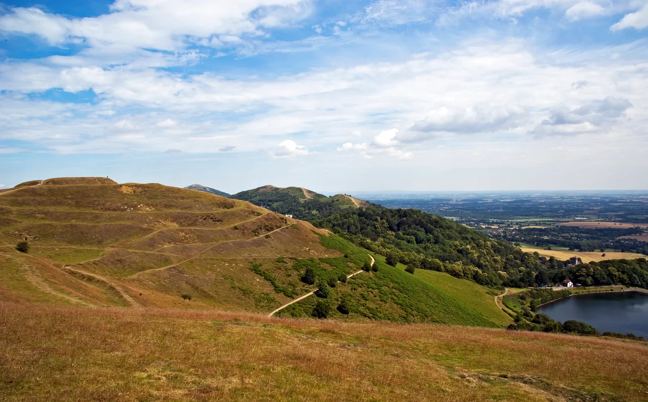

British Camp
The earthworks were already ancient when the Romans arrived. Two thousand years before Britain learned the word England, Iron Age hands had cut concentric terraces into the summit of Herefordshire Beacon, ring after ring rising 1,109 feet above the Severn plain. Walk the ramparts today and the shape that emerges underfoot has been compared, accurately and a little absurdly, to a giant wedding cake. The diarist John Evelyn climbed up here in the 17th century, looked west toward the Welsh mountains and east across the chequered Worcestershire fields, and called it "one of the godliest vistas in England." He was not the first to think so. Whoever decided this hilltop deserved 44 acres of defensive ditches and counterscarp banks had reached the same conclusion in the 2nd century BC.
Wedding Cake in the Sky
From the air the shape is unmistakable: three terraces stacked one above another, encircling the central citadel like ripples in stone. The whole perimeter runs 6,800 feet around three hills, though the northern and southern lobes are little more than spurs of the main beacon. Archaeologists have identified at least four prehistoric phases of building, with original gates to the east, west, and north-east. Round hut platforms still pock the inner terraces, suggesting this was no temporary refuge but a permanent home for hundreds of people. A mile to the south stands Midsummer Hill, another Iron Age fort of comparable scale. Two great strongholds within shouting distance of one another is unusual in British archaeology, and what it meant - rivalry, alliance, or some federation of tribes long forgotten - is anyone's guess.
The Caratacus Question
Every Iron Age hillfort west of the Severn has, at some point, been claimed as the last stand of Caratacus, the British chieftain who fought the Roman conquest of 43 AD for nearly a decade before finally being defeated and taken to Rome in chains. British Camp wears that legend more proudly than most. Local tradition insists the chieftain made his final stand here in 51 AD; Edward Elgar even wrote a cantata, *Caractacus*, inspired by gazing up at the Beacon from his Malvern home. The historian Tacitus, who knew the country only by report, described a battle site closer to the River Severn, and the Severn lies eight kilometres away across the Worcestershire plain. The likelier candidates - Caer Caradoc in Shropshire, sites near Brampton Bryan - are far less photogenic, which is perhaps why the legend stuck. Excavations at nearby Midsummer Hill, Bredon Hill, and Croft Ambrey all show violent destruction around 48 AD, hinting that whatever ended hillfort life on this ridge did so brutally and around the same time.
Harold's Last Castle
Iron Age earthworks have a way of inviting reuse, and in the decade before 1066 someone built a ringwork-and-bailey castle inside the old prehistoric defences. The probable builder was Earl Harold Godwinson, who would die at Hastings as the last Anglo-Saxon king of England. Harold also raised Longtown Castle in the same county; Herefordshire was border country, and Welsh raids made fortified high points worth the labour. The castle survived him by a century. During the chaos of King Stephen's reign - the period chronicles called simply The Anarchy - it changed hands repeatedly, held first by Waleran de Beaumont, Earl of Worcester, then assaulted by royalists in 1151 and 1153 and defended by men loyal to Waleran's brother, the Earl of Leicester. In 1155, the young Henry II demolished the place to discourage further baronial freelancing. By the time William Langland wandered these hills writing *Piers Plowman* in the 1370s, the castle was a ruin to mention in passing.
The Red Earl's Dyke
Run a finger north or south along the ridge from the summit and you trace the Shire Ditch, a low linear earthwork that snakes for miles across the Malvern crest. It is also called the Red Earl's Dyke, after Gilbert de Clare - Earl of Gloucester, son-in-law of Edward I, and a man given to spectacular boundary disputes. In 1287 he and Thomas de Cantilupe, the Bishop of Hereford, fell out so badly over hunting rights that Gilbert had this ditch dug to mark the limit of his claim. Modern survey work suggests parts of the alignment may be far older than the Earl's quarrel - perhaps a prehistoric trackway connecting Midsummer Hill to the Worcestershire Beacon three miles north. The medieval ditch may simply have followed a line already worn by feet that walked here a thousand years before Gilbert was born.
What You See From the Top
On a clear day the view from British Camp gathers thirteen English counties and a fair slice of Wales. The Black Mountains crouch on the western horizon; the Vale of Evesham unrolls to the east; the silver curl of the Severn threads south toward the Bristol Channel. The Malvern Hills are made of some of the oldest rock in Britain - Precambrian gneiss roughly 680 million years old, harder than the soft red sandstone of the plain - which is why they rise so abruptly from such gentle country. Today the site is a Scheduled Ancient Monument, looked after by the Malvern Hills Conservators. The wedding-cake terraces still hold their shape, the view still bears Evelyn out, and somewhere in the ground beneath your feet are the post-holes of houses where children played in 200 BC.
From the Air
Located at 52.058°N, 2.352°W on the Herefordshire-Worcestershire border, the summit reaches 1,109 ft. Best viewed at 2,500-4,000 ft AGL with the Malvern ridge running north-south as the dominant landmark - British Camp sits at the southern end of the chain, with the higher Worcestershire Beacon three miles to the north. Nearest airfields: Gloucestershire (EGBJ) 20 nm south, Wolverhampton (EGBO) 25 nm north-east. The Severn plain offers wide unrestricted visibility; haze is common in summer.
Nearby Stories
- Kidderminster 2.5 km away
- Stokesay Castle 5.4 km away
- White Castle, Monmouthshire 6.2 km away
- National Motorcycle Museum (UK) 7.7 km away
- Church of the Holy Trinity, Stratford-upon-Avon 8.2 km away
- Prinknash Abbey 8.3 km away
- Dore Abbey 18 km away
- Woodstock Palace 27 km away