The Fortress That Swallowed a Hilltop
Twelve gates pierce the walls of the Buton Palace Fortress, and the Wolio people will tell you each one corresponds to a hole in the human body. The fortress is the body. The sultan is the soul. Walk through any of the twelve lawa and you step inside what was once a living political organism -- a walled city on a hilltop where the sultans of Buton governed for four centuries, from the 1590s until Indonesia dissolved the sultanate in 1960. The fortress sits atop a steep hill above the port city of Baubau, on the southern tip of Buton Island in Southeast Sulawesi. Its stone walls run 2,740 meters around the summit, enclosing mosques, royal graves, and the ruins of a constitutional monarchy older than many European parliaments.
Stones Piled Against the World
The fortress began modestly. When Sultan Buton III, La Sangaji -- titled Sultan Kaimuddin -- took power around 1591, he ordered stones piled around the palace complex to separate the royal grounds from the surrounding community. It was a fence, not a fortification. But Buton Island sat at a strategic chokepoint on the spice trade routes between Java, Makassar, and the Moluccas, and fences do not stop empires. Under Sultan Buton IV, La Elangi -- known as Sultan Dayanu Ikhsanuddin -- the piled stones became permanent walls. By 1613, the fortress had acquired sixteen bastions, called baluara, a word borrowed from the Portuguese baluer. Two of these bastions housed godo, warehouses for gunpowder and ammunition. The Portuguese and Dutch both left their mark here in the form of bronze cannons, the badili, which still sit in fortifications across Baubau.
A Constitution Before the Word Existed
What makes the Buton Sultanate extraordinary is not the size of its fortress but the document it produced inside those walls. Sultan La Elangi formalized the Murtabat Tujuh, a written constitution that governed the sultanate from his reign beginning in 1597 until the institution's dissolution more than three centuries later. Unlike the absolute monarchies common across the Indonesian archipelago, Buton operated as a constitutional monarchy with codified laws. The sultanate had converted to Islam in 1540, when its sixth king became a follower and restyled the kingdom accordingly. The Great Mosque of Wolio still stands within the fortress walls, surrounded by the old tombs of sultans that local people continue to regard as sacred. Manuscripts from the sultanate era survive in private collections, many of them still unread by scholars.
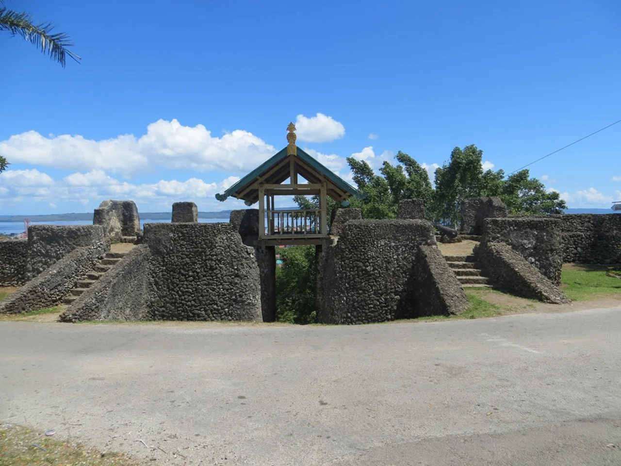
Through the Twelve Gates
Each of the twelve lawa bears the title of its appointed guardian, the gate's name fused with the Wolio suffix na -- meaning "its" -- to form lawana, a possessive that ties the gate to its keeper. The gates vary in construction: some built entirely of fitted stone, others combining stone with wooden upper structures that served as observation towers, small gazebos perched above the entrances where watchmen could scan the Strait of Buton for approaching ships. From the fortress edge, the view drops steeply to Baubau below and the strait beyond, where vessels still pass between the islands. The sixteen baluara follow the contours of the hilltop, each shaped to the terrain where it sits, each named for the village that once stood beside it inside the palace walls.
What the Hilltop Holds
In September 2006, the Indonesian World Records Museum and the Guinness Book of Records recognized the Buton Palace Fortress as one of the largest fortified enclosures in the world. The claim rests on the area enclosed within its perimeter walls -- a figure that encompasses the hilltop settlement, not merely the palace grounds. Heritage performances are still staged inside the fortress, and the site draws visitors who climb the steep approach to walk the walls and peer out over the rooftops of modern Baubau. The sultanate that built this place lasted from the early fifteenth century until 1960, when the Indonesian government formally incorporated its territory. Four and a half centuries of continuous governance, bookended by piled stones and a nation-state. The walls remain. The cannons remain. The mosque remains. The constitution, remarkably, outlasted them all in spirit if not in law.
From the Air
Located at 5.47°S, 122.60°E on a prominent hilltop above the port city of Baubau, on the southern tip of Buton Island, Southeast Sulawesi. The fortress walls are visible from altitude as a ring crowning the hill above the city. Nearest airport is Betoambari (WAWB/BUW) approximately 5 km south of the fortress. The Strait of Buton separates the island from the Sulawesi mainland to the west. Best viewed from the south or east approach to Baubau at 3,000-5,000 ft.
Nearby Stories
- The Coral Archipelago Spelled Out in Islands 65 km away
- Sulawesi's Hidden Wetland: Rawa Aopa Watumohai 99 km away
- Coral Over the Sands 135 km away
- Kendari: The Bay That Built a City 146 km away
- The Village That Said No to the Modern World 183 km away
- The Bluff That Worked and the Storm That Didn't Care 225 km away
- Mount Ile Lewotolok: The Fire Mountain on Its Own Peninsula 279 km away
- The Island That Imprisoned a Nation's Greatest Writer 446 km away