The Coral Archipelago Spelled Out in Islands
The name is a puzzle solved in geography. Take the first syllables of four islands - WAngi-wangi, KAledupa, TOmia, BInongko - and you get Wakatobi, an administrative acronym that somehow sounds like a word the sea itself might have invented. Traditionally called the Tukang Besi Islands, this scattering of roughly 150 islands off the southeastern arm of Sulawesi became its own regency in 2003. But long before Indonesian law gave it a name, the reefs and waters here had already earned a reputation among marine biologists as one of the most extraordinary coral ecosystems anywhere on the planet.
Where the Coral Triangle Breathes
Wakatobi National Park, established in 1996, encompasses 1.39 million hectares of marine territory within the biodiversity hotspot known as Wallacea. The park lies within the Coral Triangle, the roughly six-million-square-kilometer expanse spanning Indonesia, Malaysia, the Philippines, Papua New Guinea, Timor-Leste, and the Solomon Islands that harbors the greatest concentration of marine species on Earth. Waters here plunge to 1,044 meters at their deepest, and the reefs rank among Indonesia's highest priorities for marine conservation. In 2012, UNESCO designated Wakatobi a Biosphere Reserve, recognizing not just the ecological significance but also the interdependence between the archipelago's human communities and the sea that sustains them.
Sea Nomads and Island Smiths
Eight ethnic groups inhabit Wakatobi, but two define its character. The Wakatobi people themselves make up over 91 percent of the population, while the Bajau - sea nomads whose lives are woven entirely around the ocean - account for nearly 8 percent. The Bajau of Wakatobi build their homes on stilts over the water in settlements like Sampela village off Kaledupa, living between surface and seafloor in a way that has fascinated anthropologists for generations. Meanwhile, the old name Tukang Besi means "ironworkers," a reference to the metalsmithing tradition of Binongko Island, where blacksmiths once forged tools and weapons that were traded across the region. The film The Mirror Never Lies, a collaboration between WWF-Indonesia and the Wakatobi administration, brought the Bajau way of life to international audiences and earned an Honorable Mention at the Global Film Initiative.
Fortresses Above the Reef
Each of Wakatobi's four main islands guards relics of the Sultanate of Buton, under whose authority the archipelago fell before Indonesian independence. Stone forts crown hilltops and cliff edges across the chain. Liya Fort on Wangi-wangi encloses four concentric walls pierced by twelve ceremonial doors - the Lawa - through which royals once emerged to address their subjects. The Keraton Liya Mosque still stands within its walls. On tiny Kapota Island, Togo Molengo Fort perches at the summit, reachable only by traditional boat and then a steep motorcycle climb. Palahidu Fort on Binongko clings to the northern cliffs above the sea. A Dutch-era lighthouse built in 1901 still marks the coast at Waha Village. Together, these sites trace a history of maritime defense, Islamic kingship, and colonial navigation across an archipelago whose strategic position along trade routes once made it worth fortifying.
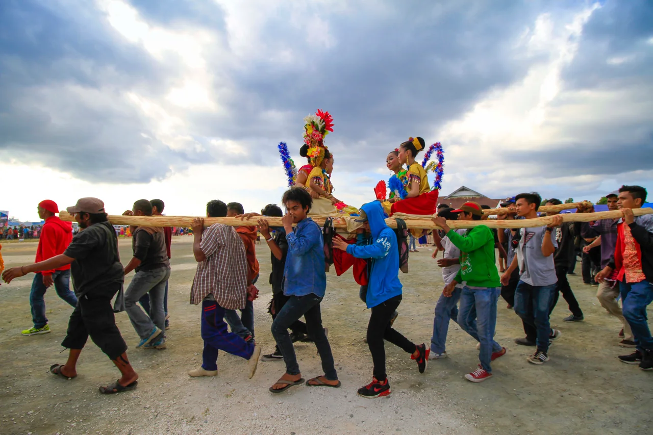
Rhythms Carried by Drum and Tide
Cultural life in Wakatobi moves to rhythms older than the regency itself. On Kaledupa, the Lariangi dance dates to 1634, choreographed during the reign of the first King of Buton, Wa Kaka. The Karia'a festival marks the coming of age of boys through circumcision, with the young men paraded through villages on stretchers borne by fifteen to twenty carriers. On Tomia, the Bose-Bose tradition sends boats festooned with colorful ornaments and loaded with traditional dishes like Liwo along the coast from Patipelong Quay to One Mobaa Strait, drums beating, the ceremony meant to carry the community's sins away with the waves. The Safara feast recurs every month of Safar in the Islamic calendar. These are not performances staged for tourists - they are living practices maintained by communities where agriculture, fishing, and faith remain tightly braided together.
An Archipelago Between Isolation and Connection
Getting to Wakatobi requires commitment. Wings Air flies to Matahora Airport on Wangi-wangi, the only scheduled air service. The alternative is a twelve-hour series of boat trips from Kendari via Baubau. Once within the archipelago, island-hopping means two hours by boat from Wangi-wangi to Kaledupa, four hours to Tomia. A private airstrip on Tomia, Maranggo Airport, serves exclusively the Wakatobi Dive Resort. The population of roughly 119,000 across 474 square kilometers of land spreads unevenly, with more than half concentrated on Wangi-wangi. The remoteness that makes Wakatobi difficult to reach is the same quality that has preserved its reefs, its forts, its dances, and the Bajau way of life - a fragile equation that the designation as a UNESCO Biosphere Reserve is meant to help sustain.
From the Air
Centered at approximately 5.32S, 123.59E in the Banda Sea southeast of Sulawesi. The archipelago stretches roughly 160 km north-south and 120 km east-west. Matahora Airport (WAWW) on Wangi-wangi Island is the main air gateway; Maranggo Airport on Tomia serves private resort traffic. Best viewed from 10,000-15,000 feet, where the four main islands and their fringing reefs are visible in clear conditions. The surrounding deep blue of the Banda Sea contrasts sharply with the turquoise shallows over the coral platforms.
Nearby Stories
- The Language That Borrowed an Alphabet from Across the Sea 51 km away
- Kendari: The Bay That Built a City 135 km away
- Southeast Sulawesi: The Province That Ferries Built 175 km away
- Coral Over the Sands 241 km away
- Mount Ile Lewotolok: The Fire Mountain on Its Own Peninsula 294 km away
- The Island That Imprisoned a Nation's Greatest Writer 335 km away
- The Banda Sea: Where Continents Collide 344 km away
- Montara Oil Spill 795 km away