Calandbrug
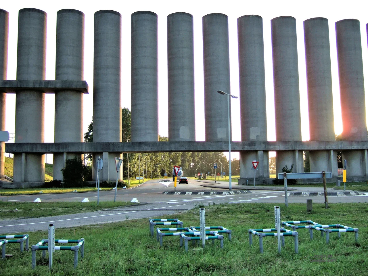
At wind force six, the car carriers stop moving. Their hulls are too tall, their freeboards too high, and the gap they have to squeeze through, the 46-meter opening below the Calandbrug's lifted span, becomes an unforgiving slot the moment a crosswind takes hold. So at the end of the Caland Canal where it bends south into the Brittanniëhaven, the Port of Rotterdam built something nobody had really built before: a 1.8-kilometer-long, 25-meter-high concrete wind barrier, an architectural windbreak made of reinforced shells that look, from the air, like a row of upturned saucers marching toward the sea. The bridge they were protecting had been finished in 1969. The barrier went up in 1986. The port was just trying to keep its cars moving.
A bridge for a brand-new sea
In the 1960s the Port of Rotterdam was inventing itself again. The old port had spread west and south along the Nieuwe Waterweg before the war, with the first petroleum harbors built west of Pernis from the late 1930s. After the war the Botlek area (1952 to 1957) and Europoort (1958 to 1964) extended the port out across the island of Rozenburg toward the North Sea. The trade was shifting from coal to crude oil, and the new tankers needed deeper water than the Nieuwe Waterweg could give them. Engineers dredged the Euro-Maasgeul out into the North Sea and built the Caland Canal parallel to the older waterway, sized for ships with 21-meter drafts that could come in regardless of tide. To stitch the two new port areas together, road and rail had to cross the new canal. Construction of the Calandbrug began in 1966, and the bridge opened on 6 June 1969.
A truss with a moving floor
The bridge stretches 343.6 meters between abutments. Three girders divide it: a fixed eastern span, a vertical-lift center section, and a long continuous girder to the west. The trusses themselves are eight and a half meters tall, parallel-chord, and asymmetric in cross-section because the railroad tracks ran along the northern side and made it heavier. Four DC motors with a combined output of a thousand horsepower drive the lift mechanism. Thirty-six steel cables, each 62 millimeters thick, run over four-meter pulleys at the tops of the 64.7-meter towers, connecting the 1,200-ton movable deck to four counterweights of 340 and 280 tons. From the closed position at 11.7 meters of clearance, the system can raise the deck 38 meters in 60 seconds, opening 49.7 meters of vertical clearance for shipping. For inland barges that don't need that much height, an 80-meter opening waits permanently beneath the adjacent through girder. Beneath everything ran four lanes of the N15 motorway, a bike and moped path, a sidewalk, and two railroad tracks.
The wind problem
The car terminals arrived in the early 1980s, taking over the north side of the Brittanniëhaven from petrochemicals. Roll-on, roll-off ships have superstructures like apartment blocks. They caught the wind. Even at a modest 30 kilometers per hour, the port had to forbid them passage under the raised span, which meant the entire harbor section was effectively closed for much of the winter. Joop Schilperoord designed the solution in 1983, working with the architect Maarten Struijs and the sculptor Frans de Wit. The Windscherm Calandkanaal, completed in 1986, runs 1,750 meters along the west bank in three sections shaped by the terrain. The southern section uses 22 free-standing semi-circular concrete shells, each 25 meters high and 18 meters across, spaced 12 meters apart. The middle section, around the bridge itself, uses narrower 4-meter shells linked by torsion-resistant beams. The northern section sits atop a 15-meter earth embankment topped with 49 ten-meter concrete slabs. Engineers tuned the structure to 25 percent permeability, with the concave faces of the shells turned toward the prevailing west wind. The result halved the wind speeds at the bridge. Ships up to wind force six could now pass safely.
Tunnels and elevated rails
The Maasvlakte expansion of 1964 to 1974 pushed the port still further west into the North Sea, and Maasvlakte 2 followed between 2008 and 2012. Traffic across the Calandbrug climbed to 45,000 vehicles per day by 1998, and roughly twelve bridge openings each day created predictable traffic jams. By 2004 the Thomassentunnel had been bored under the canal, carrying six lanes of the A15 below the water and taking pressure off the bridge above. Rail traffic kept rising too, especially after 2007 when the Havenspoorlijn became part of the Betuweroute freight corridor to Germany. Up to 58 trains crossed daily by 2010. From 2017 onward ProRail built the Theemsweg route, a four-kilometer elevated double-track bypass with tied-arch bridges over both the Rozenburg lock and the Thomassentunnel. The first freight train ran the new line on 8 November 2021, and rail service over the Calandbrug ended. The bridge had become a road bridge again, dedicated to local traffic and the careful business of moving hazardous cargo.
Sixty meters up, frozen open
In May 2022 the bridge had to close for the rest of the year. The deflection pulleys at the top of the lift towers, 60 meters above the deck, had suffered massive bearing damage. The repair was complicated by the geometry of the problem itself. To work on pulleys that high, engineers had to build a temporary support structure that could hold the movable span in the raised position while the cable system was dismantled and rebuilt. The bridge sat frozen open through the work. By the end of 2022 the Calandbrug was back in service, ready for the next decades of duty. ProRail and Rijkswaterstaat are drawing up a longer renovation plan, and maintenance will eventually pass to the Dutch national highway authority. The truss bridge with its great vertical-lift center span, the concrete shells of its wind shield, and the elevated railway curving around its southern flank: together they describe what a working port looks like when it keeps having to outgrow itself.
From the Air
The Calandbrug crosses the Caland Canal at 51.9014 N, 4.2269 E, west of Rozenburg in the Port of Rotterdam. Best viewed from 1,500 to 3,000 feet. The 64.7-meter lift towers and the long curve of the concrete wind barrier on the west bank are distinctive landmarks. Nearest airport is Rotterdam The Hague Airport (EHRD), 20 km northeast. Amsterdam Schiphol (EHAM) is 70 km north. The Maasvlakte port extension stretches further west toward the North Sea coast.
Nearby Stories
- European Cooperation for Space Standardization 2.2 km away
- Operation Pheasant 5.6 km away
- Dutch Language 8.3 km away
- Moerdijk 9.9 km away
- Amsterdam University Medical Center 10 km away
- Delta Works 11 km away
- HMS Cressy 14 km away
- Moermond Castle 24 km away