Caminho dos Gerais State Park
By the early 2000s, the people of Espinosa, Gameleiras, Mamonas, and Monte Azul could draw a map of which streams had died. Charcoal burners had been cutting and firing the cerrado for years, and eucalyptus plantations - thirsty, fast-growing, planted in blocks the size of small towns - had replaced native cover across the flat chapadas. The water went with the trees. Only one place still ran reliably: the ridge country of the Serra Geral, at the far northern tip of the Espinhaço Mountains, where limestone and quartzite kept springs alive above 900 meters. Municipal governments, civic groups, and elected officials wrote to Minas Gerais's State Forestry Institute with a simple request. Protect this mountain, or our towns lose their water. The state listened. On 28 March 2007, Governor Aécio Neves signed the decree that created Caminho dos Gerais State Park.
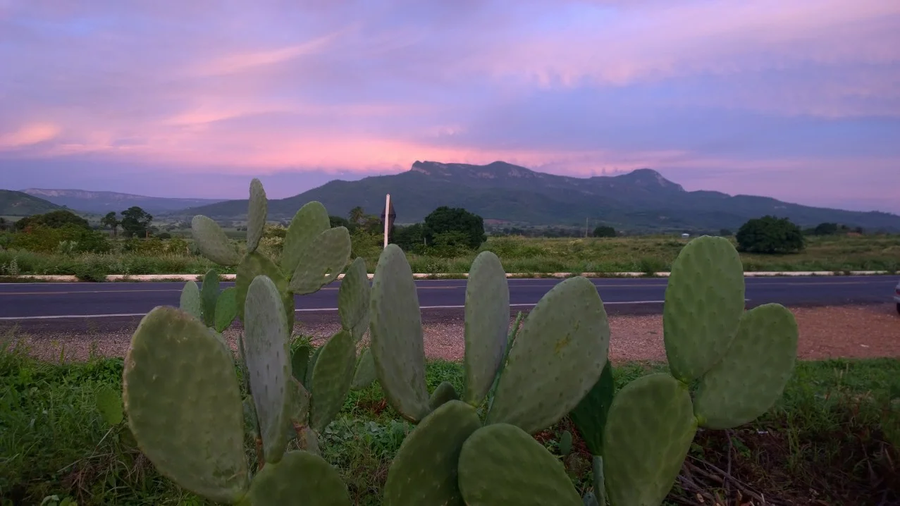
A Park on Four Municipalities
The park stretches 53,264 hectares across four jurisdictions in the arid north of Minas Gerais. Espinosa contributes 16,696 hectares, Gameleiras 20,799, Mamonas 6,128, and Monte Azul 9,664 - a patchwork that reflects who needed the water most. The terrain is rugged even by Serra Geral standards, averaging 1,090 meters in elevation, with ridges, gorges, rapids, and waterfalls breaking up the tabletop chapadas. Soils are a mix of latosols, cambisols, and quartzarenic neosols, with rocky outcrops showing through wherever the slope is steep enough to strip the cover. The Serra rises dramatically from the surrounding sertão plain - look at it from below and you see a wall of rock lifting out of a flat horizon, the kind of ridge that catches every cloud passing inland from the coast and squeezes a little rain from it before letting it move on. The state parks file describes the waterfalls as significant tourist potential. In this corner of Minas Gerais, they are also life-support.
Where the Rivers Are Born
The math of the park is the math of thirst. Annual rainfall across the region runs from 749 millimeters in Espinosa to 916 millimeters in Gameleiras - not desert numbers, but close, and concentrated in a short rainy season. Average annual temperature hovers around 24°C. For most of the year the surrounding plains stay dry. Inside the park, the ridges hold the sources of a network of streams with names that sound like the country they drain: Gameleiras, Engenho, Boa Vista, Brejo, Coronel, Jacú das Piranhas, Poço Triste, Boqueirão do Encantado, Pé de Serra, Riacho Seco, Espera, Capivara. These feed the Verde Pequeno River, which joins the Rio Verde Grande, which joins the São Francisco - the great north-south artery of interior Brazil. Protecting this ridge means protecting water that will eventually cross half the country. The municipalities that pushed for the park understood that long before the state did.
Cerrado Meets Caatinga
The vegetation in Caminho dos Gerais is a biogeographical seam. Four distinct plant communities meet here, each adapted to a different altitude and soil: ciliar gallery forest along the streams, cerrado savanna on the middle slopes, campos rupestres on the high rocky ridges above 900 meters, and caatinga thorn scrub in the drier foothills. Cerrado and caatinga are the park's dominant biomes, both of them under severe pressure across the rest of Brazil. Rare species survive in this pocket. Trees with names that sound like a Brazilian botanical census - Ipê (Tabebuia), Jatobá (Hymenaea courbaril), Pequi (Caryocar brasiliense), Pacari (Lafoensia pacari), Pau santo (Kielmeyera), Faveiro (Dimorphandra mollis), Angico (Anadenanthera colubrina) - still grow in their natural stands. The park is poorly studied by scientists. It is almost certainly a repository for endemic species that have not yet been catalogued anywhere else, surviving precisely because no one has gotten around to clearing this ridge.
The Park the Farmers Asked For
Caminho dos Gerais is unusual among Brazilian state parks because its creation was driven from below. Land-use conflicts in Brazil's interior typically run the other way: farmers resist conservation, conservation is imposed, resentment lingers. Here, the farmers asked. Agriculture, livestock, and eucalyptus plantations had degraded so much of the surrounding chapada that the municipalities themselves saw the remaining native cover as economic infrastructure - water-infrastructure - worth protecting with the force of law. The park is a fully protected unit, administered by the State Forestry Institute of Minas Gerais, with the purpose of preserving fauna, flora, and the sources of rivers and streams while supporting scientific, educational, and recreational use compatible with conservation. The trails remain under development; the tourist potential the founding documents mention is still more promise than product. But the streams still run. In a sertão where the streams that don't run have names on old maps, that is the point.
From the Air
The park is centered near 15.03°S, 43.05°W on the Serra Geral at the northern end of the Espinhaço range in Minas Gerais, just south of the border with Bahia. Cruise at 8,500 to 10,500 feet to appreciate the ridge rising 600 to 700 meters out of the surrounding sertão plains - the escarpment is the most obvious visual landmark, with the quartzite chapadas running roughly north-south. Nearest airports are Montes Claros (SBMK) about 90 nautical miles south and Guanambi (SNGI) about 80 nautical miles northeast. The region is dry and sunny from May through October, with excellent visibility; the wet season from November through March brings afternoon convective storms that can rapidly build over the ridge.
Nearby Stories
- Vargem Grande do Rio Pardo 28 km away
- São João das Missões 56 km away
- Serra Nova State Park 57 km away
- Januária 85 km away
- Atlantic dry forests 96 km away
- Brumado 113 km away
- Vitória da Conquista 184 km away
- 1798 Revolt of the Alfaiates 228 km away