
Cape Cornwall
For most of recorded history, Cape Cornwall was the place where England ended. Sailors knew it. Mapmakers drew it. The fishermen of St Just took their boats out around the cape because past it the country itself ran out. Then in the early nineteenth century the Royal Ordnance Survey arrived with their theodolites and their trigonometry, and they discovered that Land's End, four miles to the south, was actually about half a mile farther west. The official title moved. The tourist coaches followed. Cape Cornwall kept its dignity and lost most of its visitors, which is exactly the bargain anyone who comes here now is glad it made.
The Goose's Back
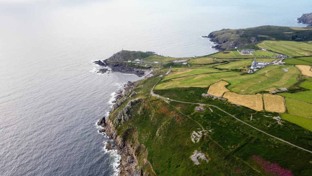
The Cornish name for the headland is Penn Kernow, a modern back-translation. The older name, the one used by Cornish-speaking villagers for centuries, meant goose's back, a reference to the long curving silhouette of the cape seen from the south. The shape is precise: a hooked promontory dropping in two stages from the village fields to Priest Cove, with the 1864 chimney of the old mine planted on its highest point like a flagpole. Almost all of the headland is now owned by the National Trust. A National Coastwatch Institution station perches on the seaward side, watching for ships in trouble. The tourist infrastructure is deliberately thin: a car park, public toilets, a refreshments counter open in summer. Nobody is trying to sell you anything else. The cape's biggest commercial sponsor put its plaque on the chimney in 1987 and went home.
Two Capes in Britain
A cape, in strict geographical terms, is a point of land where two bodies of water meet. By that definition there are only two capes in the entire United Kingdom. Cape Cornwall is one. The other is Cape Wrath in the far northwest of Scotland, around 850 miles away by road and a different country in everything but flag. The geometry on this Cornish headland is unmistakable. On the south side is the open Atlantic, the water that turns north toward the Bristol Channel. On the north side is the Celtic Sea, the body that runs up between Cornwall and Ireland. Stand at the chimney and the line between them is the cape under your feet. Two seas, two histories, one piece of rock holding them apart.
Bronze Age Burials and a Medieval Chapel
People have been coming to this point for at least three thousand years. Pottery recovered from stone-lined burial cists on the cape has been dated to the Late Bronze Age, marking Cape Cornwall as a place where the dead were laid down in roughly the same period that Ballowall Barrow just to the north was receiving its final burials. The presence of another cliff castle nearby at Kenidjack suggests the cape was a significant Iron Age site as well. On the landward slope of the headland are the ruins of St Helen's Oratory, a medieval chapel that replaced a sixth-century church on the same ground. A baptismal font now installed in the porch of St Just parish church may have come from this older building. The Christians built where the Celts had built where the Bronze Age had built. The headland is one of those places people kept choosing.
The Race From the Brisons
Once a year, the cape becomes a stadium. The Cape Cornwall Swim is held during a community sports event based on the beach at Priest Cove. Swimmers are boated out to the Brisons, the twin rocks rising from the swell a mile offshore, and dropped into the Atlantic. The race is back to the beach, through water rarely warmer than fifteen degrees Celsius and often colder, against an open sea swell coming in unimpeded from three thousand miles of Atlantic. Walkers on the cliff path look down at the lines of swimmers and shake their heads. The cape sits between two seas, attracts two heritage designations, holds three thousand years of burial sites, and once a year, has people swimming back to it from a rock that has killed ships. Cornwall does not do anything by halves on this headland.
From the Air
Located at 50.1275°N, 5.7073°W, summit at approximately 70 m (230 ft), with the 1864 mine chimney on the peak. Best viewed from 1,000-2,500 feet AGL approaching from the southwest over open water for the dramatic reveal of the hooked headland and chimney landmark. Nearest airport: Land's End (EGHC), 4 nautical miles south-southeast. The cape is unmistakable from any direction: a sharp hooked promontory between St Just and the Atlantic, with the stone chimney rising from its highest point and the Brisons offshore to the southwest. Land's End lies four miles south. From the air, the only two capes in Britain (here and Cape Wrath in Scotland) share the same rare two-seas geometry.
Nearby Stories
- Bartholomew Ledges Wreck 1.8 km away
- Carn Brea Castle 4.6 km away
- Battle off Lizard Point 12 km away
- Carnewas and Bedruthan Steps 18 km away
- King Charles's Castle 25 km away
- MV Cita 34 km away
- 1979 Fastnet Race 47 km away
- Trevose Head Lighthouse 55 km away