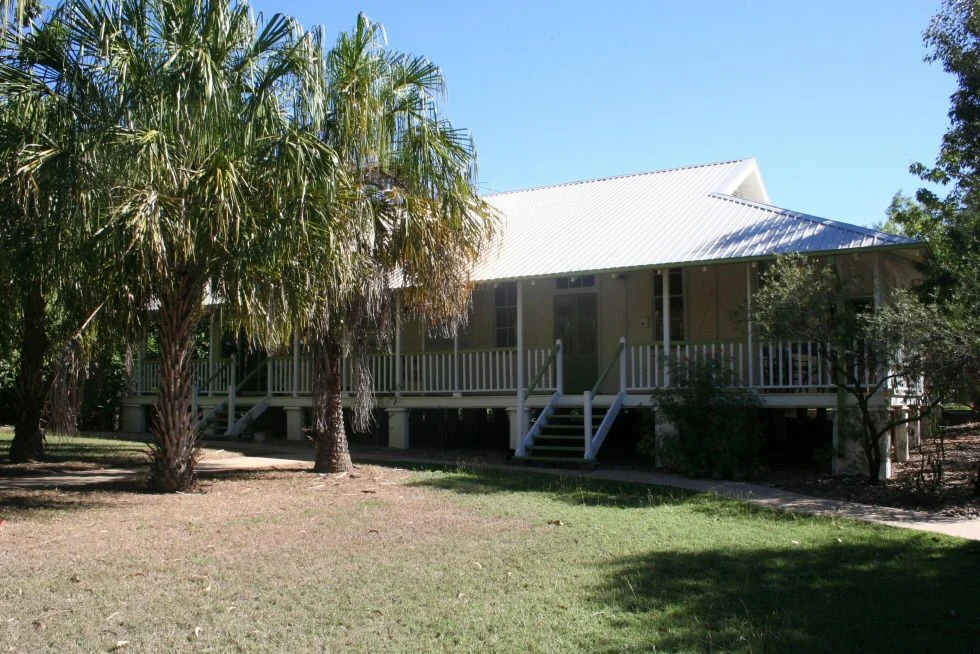

Cape Pallarenda Quarantine Station
Some of these timber buildings have been moved before. Around 1915, workers dismantled a nineteenth-century quarantine hospital across the water at West Point on Magnetic Island, ferried the pieces to the mainland, and reassembled them on a low rise behind the dunes at Cape Pallarenda. The reason was fear, the practical fear of a port city in an age before antibiotics. Ships arriving at Townsville might carry plague, smallpox, or influenza, and the people aboard had to be held somewhere apart until the danger passed. This breezy headland, with the Many Peaks Range rising behind and Cleveland Bay spread in front, became the place where the city kept its distance.
The Geography of Keeping Apart
Quarantine has always been about edges, the line between the safe and the suspect, and Cape Pallarenda sits on exactly such an edge. The station occupies a sandy shelf between coast and mountain, with Mount Marlow climbing 213 metres in the Many Peaks Range immediately behind. Sixteen timber buildings stand among regrown rainforest, framed and clad in vertical chamfered boards, lifted off the ground on concrete stumps so the tropical air could move beneath them. Deep verandahs wrap the walls; French doors open onto them; transom windows above let the heat escape. Everything about the design answers the climate. The Wulgurukaba of Garumbilbarra, the Traditional Owners, know this place as Wariganda, country that has held thousands of years of living culture long before any ship dropped anchor offshore.
Plague and the Spanish Flu
The station did its grimmest work in the first decades of the twentieth century. Bubonic plague flared in sporadic outbreaks along the Australian coast into the early 1920s, carried by ships and the rats aboard them, and Cape Pallarenda was where suspected cases were isolated. Then, in 1919, the Spanish influenza pandemic reached Queensland, and the station filled again. These were not abstract statistics. They were travellers, migrants and sailors pulled off vessels and held behind a line, some recovering on the verandahs, some not. The heritage listing notes, with unsettling candour, that the place was built partly to 'effect racial segregation', a reminder that quarantine in this era sorted people by origin as much as by symptom. The buildings absorbed all of it and still stand.
From Sick Bay to Science
When the threat of shipborne plague faded, the buildings found an unlikely second life. In 1974, the newly created Australian Institute of Marine Science moved its first staff into the old quarantine quarters and six transportable laboratories, studying the Great Barrier Reef from the very rooms that had once isolated the sick. The Great Barrier Reef Marine Park Authority, established in 1975, briefly worked here too. Both eventually moved to permanent homes, and after a quiet decade the site was gazetted as an environmental park in 1986. The grounds were replanted with native vegetation, the buildings restored in the early 1990s, and the former wards became offices for conservation and heritage staff. A place built to hold disease at bay had become a place to study and protect the reef just offshore.
Guns on the Mountain
Walk up the rocky lower slopes of Mount Marlow and you find a different layer of history. During the Second World War, when Townsville was a major Allied base and the war had come frighteningly close to North Queensland, gun emplacements and a two-storey concrete command post were built into the hillside above the station. Observation slits cut through three sides of the command post at head height. Searchlight positions, a magazine, and rock-lined drainage channels survive among the scrub, some still bearing traces of camouflage paint. From here, gunners watched the northern approaches to the harbour. It is a strange coincidence of purpose, this headland that spent the twentieth century watching for two kinds of invader, one microscopic and one armed.
From the Air
Cape Pallarenda Quarantine Station lies at 19.192°S, 146.770°E, on a low rise behind coastal dunes at the northwestern edge of Townsville, where the Many Peaks Range meets Cleveland Bay. The dominant nearby landmark is Mount Marlow (213 m), with the surrounding Town Common and Cape Pallarenda Conservation Park forming a green wedge between the city and the sea. The WWII gun emplacements scar the lower slopes northwest of the timber buildings. Townsville Airport (IATA TSV, ICAO YBTL) sits roughly 5 km southeast, and approaches from the north pass directly over the cape, giving a clear view of the headland, the dune line, and Magnetic Island 7 km offshore. Tropical visibility is best in the cooler dry-season mornings; wet-season afternoons bring cloud and haze over the ranges.
Nearby Stories
- Ayr 13 km away
- SS Yongala 34 km away
- Great Palm Island 35 km away
- Bindal People 50 km away
- Cardwell UFO Festival 83 km away
- Hinchinbrook Island 113 km away
- Porcupine Gorge 215 km away
- Samarai 998 km away
Sources
- Cape Pallarenda Quarantine Station - Wikipedia
- Cape Pallarenda Quarantine Station (former) - Queensland Heritage Register
- Australian Institute of Marine Science - Wikipedia
- Great Barrier Reef Marine Park Authority - Our Story
- Cape Pallarenda Conservation Park - Queensland Parks and Wildlife
- Mount Marlow via Lagoon Track - AllTrails