
Carnarvon Gorge
Drive out across the dry, spinifex-coloured plains of central Queensland and the land gives little warning. Then it opens. Carnarvon Gorge cuts down through six hundred metres of pale sandstone, a green ribbon of creek and forest hidden inside cliffs that glow white in the sun. Where the country above is parched, the gorge floor is cool and damp, fed by springs that almost never fail. For the Bidjara, Karingbal, and Kara Kara peoples this has been a place of profound significance for thousands of years, and one look down its sheer walls, with palm fronds catching the light far below, makes the reason plain.
Carved by Patient Water
Carnarvon Gorge is the work of water and time. For roughly twenty-seven million years, Carnarvon Creek has cut its way down through the Central Queensland Sandstone Belt, winding more than thirty kilometres and carving the gorge ever deeper. The spectacular cliffs are Precipice Sandstone, a porous rock that drinks rainfall and feeds it into the vast Great Artesian Basin beneath the continent; here, at the surface, that same stone gives the gorge its springs. Below it lies an impermeable layer that holds the water near the surface, which is why Carnarvon Creek is so astonishingly reliable, known to have stopped flowing only twice since records began. In drought, when the surrounding semi-arid country bakes, the gorge becomes an oasis, a refuge that has sheltered life long since vanished from the plains around it.
A Refuge of Living Fossils
That dependable water has made the gorge a sanctuary for plants found almost nowhere else. Two are considered its icons. The cycad Macrozamia moorei, endemic to central Queensland and tied to ancient basalt flows, raises its stiff fronds in the woodland like a relic of a greener age. The Carnarvon fan palm, Livistona nitida, clusters along the spring lines and side canyons, its tall green crowns lining moss gardens and shaded amphitheatres of stone. Side gorges branch off the main track into hushed, fern-walled chambers, the Moss Garden, the Amphitheatre, Wards Canyon, where the air is thick and cool and the light filters down green. Three broad vegetation types meet here, and the patchwork of soils weathered from each rock layer helps explain why so much life crowds into one narrow valley.
Galleries of Ochre and Stone
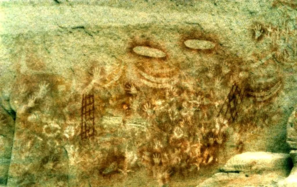
The gorge's walls are also one of the great canvases of Aboriginal Australia. At the Art Gallery, a sandstone face some sixty-two metres long carries around two thousand engravings, ochre stencils, and free-hand paintings, with close to six hundred stencils alone, hands by the hundred, alongside boomerangs and feet, the most common forms. Further in, Cathedral Cave shelters well over a thousand motifs beneath an overhang that has guarded them from the weather. These stencilling techniques are regarded by many researchers as among the most sophisticated in the world, and the sites have been in use for at least three and a half thousand years. To the peoples of this country the gorge is woven into the Dreaming: the Rainbow Serpent is said to have made these chasms and to dwell still in their permanent waterholes. Some accounts hold that people did not live here permanently because the place was too sacred to occupy lightly.
Conflict, Loss, and Protection
The peace of the gorge belies a violent recent history. After Ludwig Leichhardt passed nearby in 1844 and Thomas Mitchell named the Carnarvon Range two years later, their reports of good pasture brought settlers, and with them a period of bloody conflict between the newcomers and the Aboriginal peoples whose land it was. By the late 1870s the settlers had prevailed. Many surviving Aboriginal people sought shelter on sympathetic properties; many more were forcibly removed to distant government and church missions, a slow severing from country that some consider to have done even deeper cultural damage than the killing that came before. Grazing and farming still thrive in the surrounding district, but in 1932 the gorge itself was gazetted as a national park, ending those activities within its walls. Today it is the most visited corner of Carnarvon National Park, and a place where geology, deep time, and living culture are all written on the same towering stone.
From the Air
Carnarvon Gorge lies at approximately 25.03 degrees south, 148.18 degrees east, in central Queensland's Carnarvon National Park, about 593 km northwest of Brisbane between the small towns of Injune and Rolleston. From the air the gorge is unmistakable: a deep, sinuous cleft of pale Precipice Sandstone cutting roughly six hundred metres into the Consuelo Tableland, its shadowed floor lined with green forest and threaded by Carnarvon Creek, with side canyons branching off the main chasm. The terrain is rugged and remote, separating the tableland from the Great Dividing Range. The nearest fields are Injune and the regional Roma Airport (YROM) to the south, and Emerald Airport (YEML) to the north; both are well distant. Conditions are usually clear and dry, though the gorge can hold cool air and morning shadow; midday light best reveals the white cliff lines.
Nearby Stories
- Hornet Bank Massacre 85 km away
- Cullin-la-ringo Massacre 88 km away
- Augustus Charles Gregory 159 km away
- Charleville 186 km away
- Queensland National Bank, Charleville 207 km away
- Charleville railway station, Queensland 229 km away
- Canal Creek Air Crash 270 km away
- Great Keppel Island 309 km away