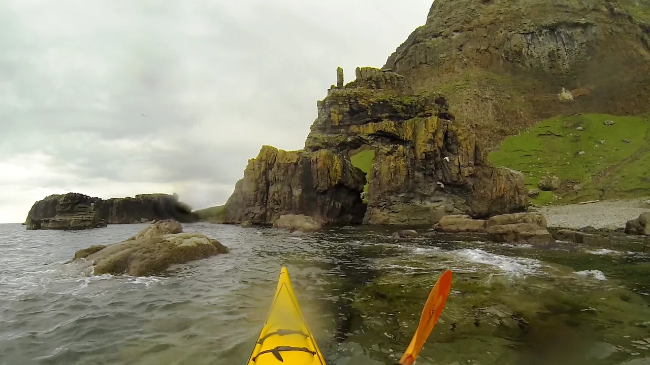

Carsaig Arches
The path begins ordinarily enough at Carsaig Pier, then turns into something else entirely. Boulders the size of cars block the way. Volcanic rubble slides underfoot. Four miles west along the base of the Rudha Fhaoilean cliffs, with the tide rising at your back, you finally descend a ridge and the first arch appears below: a dark opening cut clean through the rock, framing the sea like a window onto another world. The Atlantic boomed through this gap for millennia before anyone gave it a name. It boomed long before anyone walked here at all.
Lava and Limestone
The arches sit at the very edge of the Ross of Mull, below Malcolm's Point, where two very different rocks meet the sea. Beneath: oolitic limestone, soft enough for waves to chew. Above: columnar basalt, hexagonal shafts left over from the lava flows that built Mull around 60 million years ago. The waves found the weakness. They drilled through the limestone, hollowed caves, then broke through them entirely. What remains are two arches with very different personalities. One is described as a railway tunnel, deep and dark, where the sea sluices in even on calm days. The other rises high and theatrical, with columnar basalts hanging from the roof like petrified organ pipes. The tunnel arch measures 20 metres tall, 43 metres long, and 20 metres wide. A boat could pass through it. People rarely do.
The Keyhole and the Pillar
Beyond the tunnel stands the strangest formation of all: a pyramidal mass of rock perforated by an arch so oddly shaped that it has been called the keyhole. Above the keyhole rises a single basalt pillar, a solitary shaft of black stone standing against the sky. Geologists read it as the eroded core of something that has mostly been carried away. Walkers tend to stop talking when they see it. The whole approach has been likened to a cave entrance that leads to another planet, and the comparison is fair. There are no signs, no railings, no interpretive boards. Just the ridge, the boulder beach, the arches, and the sea.
Eagles and Goats
The cliffs above the arches are wild in every sense. Golden eagles nest along the Rudha Fhaoilean, riding thermals off the basalt face. Fulmars breed on the ledges, their oily, biscuity smell carried on the wind. Kittiwakes wheel and call. Wild goats, descended from animals abandoned during the Highland Clearances, pick their way across slopes that look impossible. Watch one for long enough and you understand the geography differently. They go where humans cannot, which is most places here. The arches are not a destination most people reach. The few who do tend to time their visit for low tide, watch for the weather, and turn back before the sea cuts off the path home.
Tide and Timing
There is no easy way to see Carsaig Arches. The walking is rough, the boulders unstable, and the path technically demands attention rather than navigation skill. The tide matters more than the map. At high water the arches can be approached only by boat, and the seas here turn rough quickly. The Lonely Planet guide calls the walk one of the finest coastal hikes in Scotland; the Admiralty's 1911 West Coast of Scotland Pilot warned mariners to give the cliffs a wide berth. Both descriptions are correct. To stand inside the tunnel arch on a falling tide, with the surf still hissing back along the floor, is to experience scale in a way that flatland geography never delivers. The rock above weighs more than imagination handles cleanly.
From the Air
Coordinates 56.293°N, 6.052°W on the southern coast of the Ross of Mull, below Malcolm's Point. Best viewed from light aircraft at 1,500-2,500 feet AGL along the coastline, ideally on a south-westerly heading at low tide when the arches are most visible against the cliff base. Nearest airports: Glenforsa Airfield (small grass strip) on Mull's east coast, Oban (EGEO) 30 nm northeast on the mainland, and Tiree (EGPU) 35 nm northwest. Atlantic swell and frequent low cloud against the cliffs require careful weather assessment.
Nearby Stories
- Colonsay 4.1 km away
- Tobermory Distillery 5.4 km away
- Gylen Castle 6.2 km away
- Strontian 11 km away
- Loch Fyne 21 km away
- Tiree 22 km away
- SS Seniority 60 km away
- HMS Audacious 75 km away