
Carthaea
There is no road to Karthaia. That is the first thing worth understanding about this ancient city. You arrive on foot, following cobbled paths that in many places trace the same lines as streets walked by Greeks in the 8th century BC, or you anchor a small boat in the sheltered bay below and climb. No ferry, no parking lot, no gift shop. The city that Pindar called a 'narrow ridge of land' has kept its solitude for fifteen hundred years, and solitude has been its preservation.
A City at the World's Edge
Karthaia occupied the southeastern tip of Kea — the Cycladic island known in antiquity as Keos — and its situation tells you something about the people who built it. Two river valleys, the Kalamitsis to the east and the Vathypotamos to the west, frame the site on either side. The sea closes it from the south. The Aspri Vigla hills rise behind. Within this natural enclosure, a city of perhaps several thousand people lived for roughly 1,300 years, from the Geometric period around the 8th century BC through to Late Antiquity in the 6th century AD. Then they left, or died, or drifted to other settlements. Karthaia did not burn or flood or get razed. It was simply abandoned, and the Aegean weather and goats took over, slowly.
What remains is remarkable precisely because no later civilization built over it. The acropolis walls — more than two kilometers of them, dated to the 6th through 4th centuries BC — still stand at significant height in places. They were not quarried for churches or fortresses in the way that so many ancient sites were. The remoteness that makes Karthaia hard to visit is the same quality that kept medieval and Ottoman builders from hauling away its marble.
Temples on Two Terraces
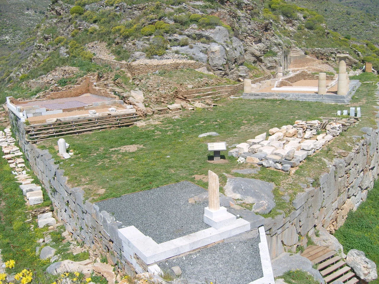
The builders of Karthaia cut two artificial terraces into the hillside to create level ground for their sacred precinct. On the lower terrace, closer to the sea, they raised the temple of Apollo Pythios around 530 BC. Ancient texts describe it as the most important building in the city-state. On the terrace in front of it, citizens placed dedications — statues, mostly — and the public decrees of the Deme of Carthaea were posted for all to read.
Higher up, a smaller temple from around 500 BC was dedicated, according to most scholars, to Athena. Its marble sculptural program depicted an Amazonomachy — a battle between Greeks and Amazons — and fragments of that carving survive today in the Archaeological Museum of Ioulis, Kea's capital. Between the two levels, a monumental Propylon of the mid-5th century BC marked the formal entrance to the upper precinct. An impressive staircase carved partly from the living bedrock led up from below. The processional way connecting the two plateaus is still visible.
Downhill, at the foot of the Vathypotamos slope, stands the theater — built in the 4th century BC and capable of seating nearly 1,000 people. Next to it, excavators have recently uncovered a complex of Roman baths, evidence that even as the wider Greek world gave way to Roman administration, Karthaia remained a place of civic life worth maintaining.
The Rediscovery
European travelers began visiting the site as early as the 17th century, drawn by references in ancient texts. For a long time they got the identification wrong, placing Karthaia at the location of the modern town of Chora — a mistake that even appeared on published maps. The correction came in 1811, when the Danish archaeologist P.O. Brøndsted spent two or three weeks excavating with thirty local workers. Ancient inscriptions found in the ground named the place explicitly; for the first time in centuries, Karthaia had its name back.
Scientific excavation began in earnest after 1900, led initially by the Belgian archaeologist P. Graindor. The most intensive modern work came between 2002 and 2015, when the Greek Ministry of Culture funded major conservation projects — supported by the European Union — that stabilized the temples of Apollo and Athena, the Propylon, Building D (a structure of uncertain function from around 300 BC, notable for its mosaic floor of white sea pebbles and purple volcanic stones), and the theater. The work continues. Archaeologists are still excavating the theater and the Roman baths.
What the Ground Holds
Karthaia was not only a religious and civic center. It was a working harbor. The ancient jetty — approximately 160 meters long and 35 meters wide — is still visible beneath the water between the site's two bays, built from rocks, slabs, and pebbles, extending out to a small rocky islet. Ships anchored here on the same principle that small boats anchor today.
Beyond the main site, the rural territory of Karthaia — its chora, or hinterland — extended across the southeastern part of Kea. Archaeologists walking those hills have found the footprints of ancient farmsteads, watchtowers, and traces of metalworking. A network of ancient roads connected them to the city, many of which were later absorbed into the traditional shepherd paths of Kea that are still in use today. The landscape is not a backdrop to the ruins; it is part of the same continuous occupation. Walk those paths and you are following Greeks who lived before the Parthenon was built.
Stillness as Legacy
After the city's final abandonment in the 6th or 7th century AD, the people who came last to Karthaia buried their dead in the ruins of the temples themselves — in the terrace of Apollo's sanctuary, in the floor of Athena's temple, among the stones of Building D. These graves, made from architectural members repurposed as tomb walls, are the testimony of the last inhabitants. They knew, presumably, that they were laying their people to rest inside something ancient and imposing, even if they no longer knew what it had been.
The Greek Orthodox church of the Theotokos of the Myrtles stands today at the top of the Aspri Vigla hill, where another ancient temple once occupied the highest point. An Early Christian basilica lies in the bed of the Vathypotamos stream, built from material taken from a temple attributed to Demeter. Layer upon layer, the site holds its record not in museum cases but in the ground itself, in walls you can still touch, in a theater where the stone seats wait in the open Aegean air for an audience that has not come in sixteen centuries.
From the Air
Karthaia lies at approximately 37.56°N, 24.33°E on the southeastern coast of Kea (Tzia), the Cycladic island visible roughly 20 km southwest of Cape Sounio. From the air at 3,000–5,000 feet, the site appears as a hillside complex above a sheltered double bay, with no visible road access from the north. The two river valleys framing the site — Kalamitsis to the east and Vathypotamos to the west — are identifiable from altitude. The nearest major airport is Athens International (LGAV), approximately 80 km to the northwest. The island's highest point reaches 560 m. Visibility in this part of the Aegean is typically excellent in summer, with the island's distinctive shape — 19 km north to south, 9 km east to west — making it easy to identify against the deep blue of the Aegean.
Nearby Stories
- Anagyrous 8.9 km away
- Serifos 14 km away
- Greek Cruiser Elli (1912) 17 km away
- Hellenic Centre for Marine Research 23 km away
- Greek Islands 23 km away
- MS Express Samina 24 km away
- Karystos 25 km away
- Spetses 68 km away