.jpg)
Karystos
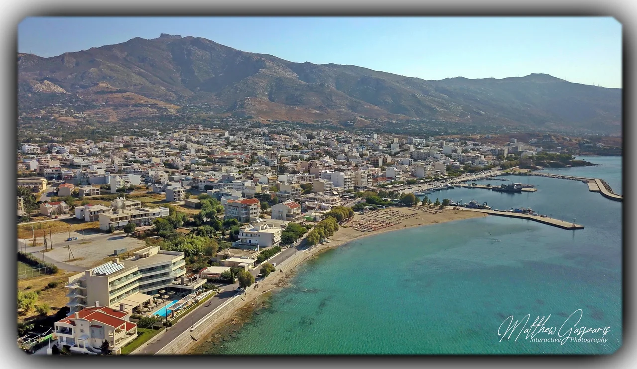
The streets here run straight and cross at right angles, which on a Greek island feels almost like a mistake. Most Aegean towns tumble downhill in a tangle of whitewashed alleys, but Karystos was drawn with a ruler. After the Greek War of Independence, in the middle of the 19th century, the Bavarian engineer who shaped the new town laid out a tidy grid facing the sea - a small, deliberate piece of order tucked into the wild southern tip of Euboea, with Mount Ochi rising behind it and the open water of the Cavo D'Oro channel stretching south toward the Cyclades.
The Emperors' Green Marble
Long before the grid, Karystos was famous for its stone. On the southern flanks of Mount Ochi, between the modern villages and the sea, lie the abandoned quarries that once supplied the Roman Empire with cipollino - a pale marble shot through with wavy green bands, as if someone had sliced an onion and turned it to rock. The Romans called it marmor carystium, marble from Karystos, and prized it. Under Caesar and Augustus, gangs of workers cut enormous monolithic columns straight from the mountainside and floated them out to ships. Those green columns travelled to Rome, North Africa, Egypt, and the Levant. Some still stand in Hadrian's Library in Athens. Walk the quarry slopes today and you find half-finished columns abandoned mid-cut, lying exactly where a crack or an imperial whim left them two thousand years ago.
The Red Castle on the Hill
Four kilometers inland, on a conical hill called Montofoli, the ruins of Castello Rosso brood over the plain. The name means Red Castle, earned by the reddish local slate that glows under the Aegean sun. The Byzantines raised the first fort here around 1030; the Frankish baron Ravano dalle Carceri rebuilt it in stone after the Fourth Crusade. The Venetians coveted it for a century before they finally bought it, then the Ottomans strengthened it further. During the 1821 revolution, fighters including Nikolaos Kriezotis - remembered as the lion of Evia - besieged it again and again without success. The gates did not open to free Greeks until 1833. Below the castle, on the eastern beach, the squat Venetian sea-tower of Bourtzi still stands guard over the harbor.
Houses Built for Dragons
Up on the bare summit ridges of Mount Ochi sits something no one can fully explain. The drakospita - dragon houses - are megalithic structures built from massive slabs of stone stacked without mortar, held together by sheer weight. Around twenty-three of them survive across southern Euboea, near Styra and Karystos. The largest and best preserved crowns Mount Ochi itself, near the summit at around 1,386 meters. Their roofs are corbelled from converging stone, leaving a narrow slot for light. No one agrees who built them, or exactly when, or why. Temples to the gods? Watch-posts? Their alignment hints at an astronomical purpose, possibly reaching back to around 1100 BC. Locals, unable to imagine human hands moving such stones, decided dragons must have done it.
A Town of Quiet Layers
Modern Karystos is a working town of roughly five thousand people, the kind of place Athenians escape to when the capital grows unbearable. The ferry from Rafina docks at Marmari, and from there the road curls around to the grid by the bay. Its small museum in the Yokaleion Cultural Centre holds Hellenistic and Roman sculpture pulled from the surrounding earth, a reminder that the ancient town of Carystus stood near here too - birthplace of the physician Diocles and the Olympic boxer Glaucus. The whole place is stitched from layers: Neolithic caves at the foot of Ochi, imperial quarries, a crusader castle, a Bavarian street plan. They sit together comfortably, none erasing the others.
From the Air
Karystos sits at 38.02°N, 24.42°E, on the southern coast of Euboea at the foot of Mount Ochi (1,394 m). The conical hill of Montofoli with the Castello Rosso ruins is the clearest visual landmark, 4 km inland. The Cavo D'Oro channel separates the cape from the Cyclades to the south. Nearest major airport is Athens International (LGAV), roughly 80 km southwest across the Petalioi Gulf and Attica. Best viewing altitude 3,000-5,000 ft on a clear day; afternoon north winds can be strong over the cape.
Nearby Stories
- Davelis Cave 3 km away
- Hellenic Centre for Marine Research 6.6 km away
- Greek Islands 7.2 km away
- Amarynthos 8.3 km away
- HMHS Britannic 17 km away
- Archdiocese of Naxos, Tinos, Andros and Mykonos 30 km away
- Oktonia 33 km away
- Aegean Sea 36 km away