
Castell Nadolig
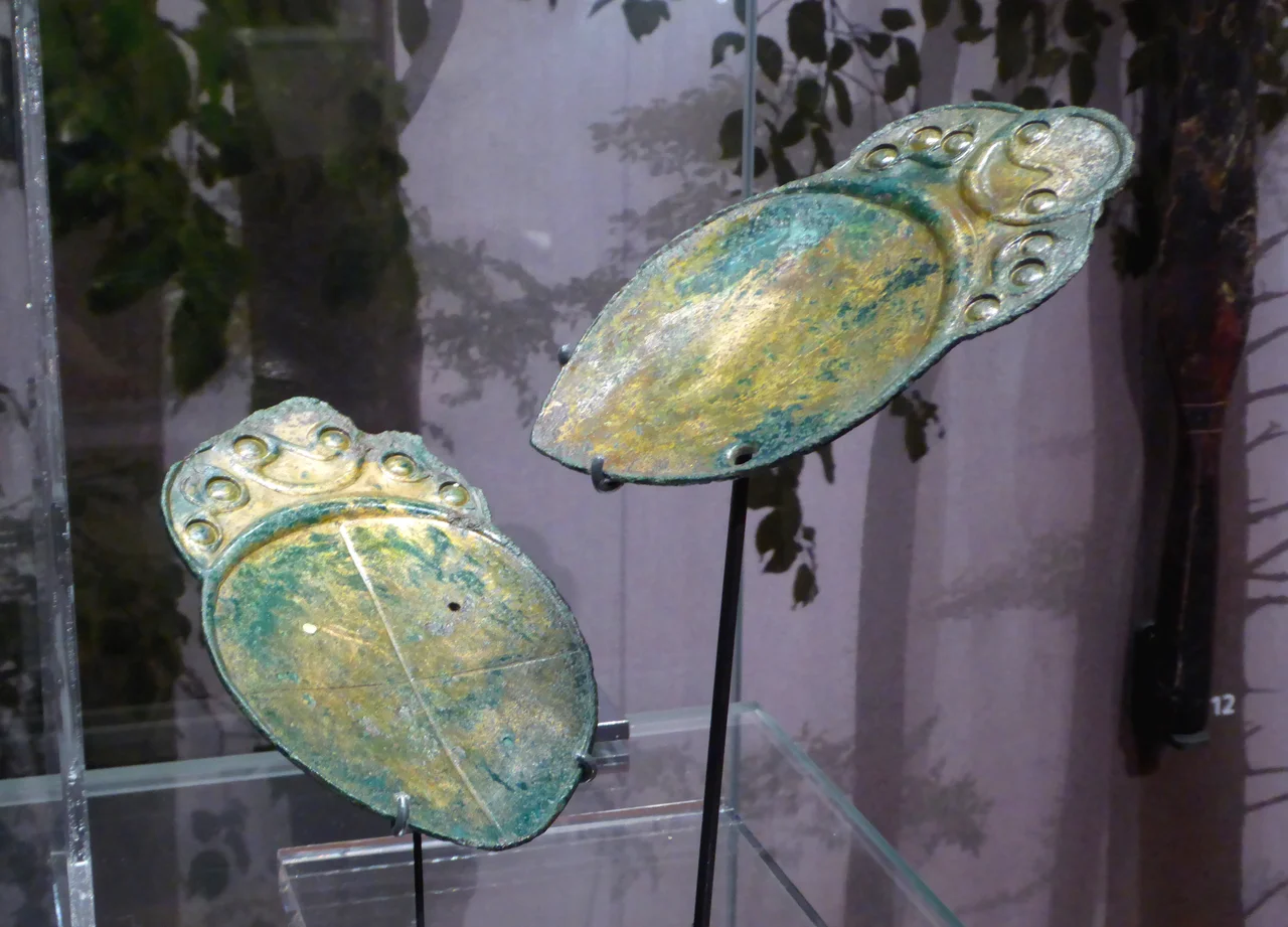
The name means Christmas Castle, and nobody is sure why. The hillfort sits on a low summit a short walk from the village of Penbryn in southern Ceredigion, ramparts now blurred into hedgebanks but still tracing a double ring around a green plateau. Sometime in the late Iron Age, perhaps between the first century BC and the first century AD, a small bronze spoon with a hole drilled through one corner was placed here, along with its companion spoon, marked with an incised cross. A farmer found them in 1829 beneath a heap of stones inside the fort. A clergyman donated them to Oxford in 1836. They have been at the Ashmolean Museum ever since, and what they were for is a mystery that two centuries of archaeology has still not solved.
A Christmas Castle on the Ridge
Castell Nadolig means Christmas Castle in Welsh; nadolig is the modern Welsh word for Christmas, derived from the Latin natalicia, festival of birth. Whether the fort was so named because of a midwinter event recorded only in memory, or because of a misheard older name, or for some entirely lost reason, is not known. It sits on a slight rise next to the modern A487 road, which here may follow the line of an ancient ridgeway. The fort has two concentric defensive banks. The outer rampart measures about 230 metres west to east by 185 metres north to south, enclosing 3.8 hectares; the inner ring is a tighter ellipse, 130 by 78 metres, enclosing 0.84 hectares. What survives is partial: the ramparts now stand 2 metres high and about 7 metres wide at the base, blended into field hedgebanks. Later farmers built crossbanks between the rings to make fields. The fort has not been excavated in modern times, and what lies beneath the turf is essentially undisturbed.
The Spoons
In 1829, the tenant farmer working the land found two objects of cast bronze beneath a pile of stones inside the inner enclosure. Each spoon is small, with a short flat handle decorated in the curving styles archaeologists call La Tene, a Celtic art language that travelled from central Europe to Ireland and west Wales. One spoon has a small hole drilled near the rim of its bowl. The other has an incised cross dividing its bowl into four quadrants. They are usually thought to date from somewhere between 50 BC and AD 100. The Rev. Henry Jenkins acquired the pair and donated them to the Ashmolean Museum in Oxford in 1836, where they remain. About twenty-five similar spoons have been found across Britain, Ireland, and northern France, almost always in pairs, almost always with one having the hole and one having the cross.
What Were They For?
Nobody knows for certain. The leading interpretation among Iron Age specialists is that the spoons were used for divination: a liquid, perhaps blood, perhaps water, perhaps a herbal infusion, was poured from the spoon with the hole onto the spoon with the cross, and the pattern of drops in each quadrant was read for meaning. The cross-divided bowl resembles divinatory boards from later cultures, where the corners or quarters might represent directions, gods, futures, or fates. Other suggestions have been made: that the spoons were used in a ritual meal, or that they served some priestly anointment. What is striking is the geographic distribution. They cluster on the Celtic-speaking western fringe of Europe, from west Wales and Ireland through Brittany. The Penbryn pair are among the best preserved. They would have been treasured and carefully made; depositing them on the hilltop was an act of intention, perhaps a grave good, perhaps an offering.
The View from the Bank
Standing on the outer bank in late afternoon, you can see the line of the coast. Aberporth lies a couple of miles to the west, the cliffs above Penbryn drop away to the long curve of sand and sea, and to the south the land rolls back toward the Preseli Hills. The Iron Age people who built Castell Nadolig commanded a wide view of farmland and coast, and probably controlled a substantial population. The double ramparts would have been higher and topped with timber palisades, and would have presented a formidable presence on the ridge. Whether the fort saw warfare, or whether its display function mattered more than its military one, is impossible to know without excavation. The Romans arrived in west Wales in the late first century AD, and these hillforts gradually fell out of use, the population shifting down to farmsteads on more workable ground.
A Scheduled Monument
Castell Nadolig is a scheduled monument, protected by Cadw, the Welsh historic environment service. It is on private agricultural land but the outline can be seen from a footpath, and the Royal Commission on the Ancient and Historical Monuments of Wales has published surveys describing what is visible. The Penbryn Spoons, removed nearly two centuries ago, remain among the most enigmatic objects from British prehistory; you can see them at the Ashmolean today, displayed with a few other Iron Age finds, small and unassuming and entirely opaque about the meaning they once carried. A field with a name, a low double ring of earth, and two spoons in a glass case in Oxford. That is what is left.
From the Air
Located at 52.13 degrees north, 4.49 degrees west on a low ridge about 2.5 miles east of Aberporth in Ceredigion. Cruise altitude 2,500-4,000 feet, ideal for catching the ramparts as shadow lines in low side-lighting. The MoD Aberporth danger area is immediately west; check NOTAMs before flight. Nearest airfield is Aberporth (MoD, EGUC); Haverfordwest (EGFE) to the south is the nearest civil alternate.
Nearby Stories
- RAF Haverfordwest 3.7 km away
- Great Western Railway in West Wales 7.7 km away
- West Wales 9.9 km away
- Fishguard Lifeboat Station 13 km away
- Battle of Mynydd Hyddgen 15 km away
- Strata Florida Abbey 18 km away
- Neath and Tennant Canal 21 km away
- HMS Tyler 44 km away