Cavernas do Peruaçu National Park
Inside the Gruta do Janelão the Peruaçu River has carved a chamber so tall that its upper arch is lost in darkness, with daylight pouring through karst windows in the ceiling like light through a cathedral's clerestory. Painted on the rock walls in ochre and white are figures that someone made more than 10,000 years ago - human silhouettes, deer, abstract geometries, the occasional suggestion of a ceremony that we cannot read now. In 2025 UNESCO added Cavernas do Peruaçu National Park to the World Heritage List, formally recognizing what the park's archaeologists had long known: that this stretch of limestone in northern Minas Gerais is one of the most important records of early human life anywhere in the Americas.
Where the Peruaçu Cuts the Rock
The park covers 56,448 hectares across three municipalities in the far north of Minas Gerais - Januária, Itacarambi, and São João das Missões - in a transitional zone where the cerrado savanna of central Brazil grades into the caatinga thorn scrub of the northeast. The Peruaçu River crosses the park from northwest to southeast before dumping into the São Francisco River, which forms the park's long southeastern boundary. Underground, the Peruaçu has been working on limestone for millions of years, dissolving passages, collapsing ceilings, and leaving behind the largest system of caves in this part of Brazil. The park was created on 21 September 1999 under the administration of the Chico Mendes Institute for Biodiversity Conservation, which also oversees the adjacent 143,866-hectare Environmental Protection Area created a decade earlier in 1989. Next door sit the Veredas do Peruaçu State Park and the Xakriabá Indian Reserve, home to the Xakriabá people whose ancestors likely crossed these caves in their own ceremonies.
A Roof Hall Full of Daylight
The Gruta do Janelão is the park's signature cavern, and one of the largest in Brazil. Its Portuguese name means big window, earned from the enormous karst windows in its ceiling where the rock has fallen through and allowed shafts of sunlight to flood the interior. The main gallery stretches roughly 700 meters with ceilings in places more than 100 meters high; the Peruaçu River itself flows through the cave, appearing and disappearing as it meets daylight and dives back underground. Stalactites the size of trucks hang where water has been depositing calcite drop by drop for tens of thousands of years. The Dolina dos Macacos - a vast sinkhole nearby - opens the forest canopy to a round patch of sky and lets capuchin monkeys climb down its walls to drink from seasonal pools. The park's infrastructure plan, completed around 2014, opened six routes for visitors across eight caves, all designed to let a careful public see what scientists have been studying since the 1970s without trampling the art.
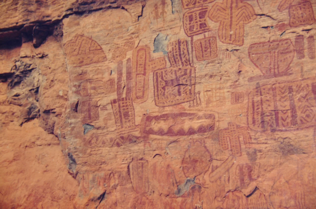
The Painters and the Paintings
The rock art inside Peruaçu's caves is what earned the UNESCO designation, and it deserves close looking. The oldest images - human figures, animal forms, handprints, geometric patterns - have been dated to more than 10,000 years ago, placing them among the earliest human artworks in the Americas. They are the work of hunter-gatherer societies whose descendants eventually became the agricultural peoples the Portuguese met at contact. Some panels in the Gruta do Janelão show scenes that scholars interpret as ritual dances or shamanic visions; others are harder to read, though the care of the pigmentation and the deliberate layout make it clear that these are not casual marks. Archaeologists working here since the 1970s - particularly the team led by Anne-Marie Pessis and André Prous - have argued that Peruaçu is not a single site but an entire cultural complex, with caves along the river serving distinct ceremonial purposes across thousands of years. The paintings have outlasted the civilizations that made them. They are still here because the limestone kept them dry and the isolation kept them safe.
Jaguar Country in Transition
Above ground the park is as biologically rich as it is archaeologically important. At the seam between cerrado and caatinga, it supports the wildlife of both: maned wolves and cougars stalk the open savanna, jaguars and ocelots hunt in the gallery forests along the river, and the colocolo - a smaller spotted cat - moves through the understory. Endemic and threatened species include the chestnut-bellied guan, the Minas Gerais tyrannulet (a tiny flycatcher found almost nowhere else), and the cave-dwelling fish Trichomycterus itacarambiensis that has evolved in the dark water of the Peruaçu system. WWF Brazil and the Instituto Biotrópicos began coordinated mammal monitoring in 2013 to track populations across the park's cerrado. The conservation challenges are real. Land ownership disputes around the park boundary remain unsettled, farms and indigenous reserves on three sides use fire routinely in their agriculture, and poachers occasionally leave fires burning when they move through. The UNESCO listing in 2025 brings international attention and, with luck, the funding to match.
From the Air
The park is centered near 15.12°S, 44.32°W in northern Minas Gerais along the São Francisco River. Cruise at 6,500 to 8,500 feet to follow the São Francisco's broad channel, with the dramatic limestone cliffs along the Peruaçu tributary marking the park's spine. Nearest airports with regular service are Montes Claros (SBMK) about 130 nautical miles south and Bom Jesus da Lapa (SBLP) about 90 nautical miles north. The region is predominantly dry with excellent VFR conditions from May through October; the wet season from November to March brings afternoon thunderstorms that can develop rapidly over the escarpment.
Nearby Stories
- Januária 12 km away
- São João das Missões 42 km away
- Janaúba 78 km away
- Caminho dos Gerais State Park 98 km away
- Mambaí 130 km away
- Posse, Goiás 192 km away
- Unaí 226 km away
- Brumado 259 km away