Cerrado
Fire made the Cerrado. Every dry season, across what scientists call the biologically richest savanna on Earth, lightning or indigenous hunters or ranchers set the grass alight, and the ecosystem responds the way it has for thousands of years: thick corky bark protects the tree trunks, dormant buds at the base of plants push up fresh shoots from the ash, seed pods crack open in the heat. Remove fire, and the Cerrado chokes on its own undergrowth. The World Wide Fund for Nature named this biome the biologically richest savanna in the world - around 10,000 plant species, eleven mammals found nowhere else, and thirty percent of Brazil's biodiversity packed into twenty-one percent of its land area. Most people have never heard of it.
The Shape of the Savanna
Stretched across central Brazil at the core of the Planalto - the Brazilian Highlands - the Cerrado spills into eleven states: Goias, Mato Grosso do Sul, Mato Grosso, Tocantins, Maranhão, Piaui, Bahia, Minas Gerais, Sao Paulo, Parana, and the Federal District. It slips briefly across the borders into Paraguay and Bolivia. Two million square kilometers, three-quarters of it privately owned. The vegetation comes in layers the botanists name for their density: campo limpo (clean field, pure grassland), campo sujo (dirty field, scattered shrubs), cerrado sensu stricto (the classic savanna of twisted trees over grass), and cerradão (wooded, nearly a dry forest). Ribbons of gallery forest follow the rivers, a green seam through the tan and russet plateau. A dry season runs roughly April through September, when the grasses crackle underfoot and the sky stays cloudless for weeks.
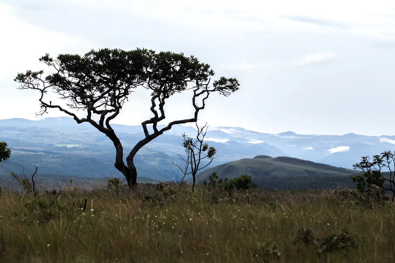
What Lives in Fire
Around 800 tree species have been cataloged in the Cerrado, many of them adapted to conditions that would kill trees elsewhere. Three species of the genus Qualea dominate much of the canopy, their thick cork-like bark insulating living tissue from surface fires hot enough to melt glass bottles. A single reserve in southeastern Brazil, at the base of Serra do Cipo, hosts the world's highest diversity of gall-forming insects - 46 species packed into a small area. Leaf-cutter ants and termites do most of the heavy lifting in the Cerrado's nutrient cycles, feeding on grasses and wood and supporting a food web that runs upward to maned wolves, giant anteaters, jaguars, and hyacinth macaws. Twenty-seven percent of the biome's birds breed only in open grassland, including the crowned solitary eagle, the dwarf tinamou, and the buff-necked ibis. The Brazilian merganser, one of the rarest ducks on the planet, still nests in a few gallery-forest streams.
Embrapa's Line of Lime
Until the 1960s, the Cerrado was agriculturally useless. Its soils are ancient, acidic, phosphorus-starved - the kind of ground European settlers had dismissed for three centuries. Then researchers at Brazil's agricultural agency, Embrapa, discovered that lime, phosphate, and the right genetics could transform the plateau into a breadbasket. In the late 1990s, Brazil was spreading between 14 and 16 million tons of agricultural lime per year. By 2003 the figure hit 25 million tons - about five tons per hectare. Embrapa scientists developed tropical soybean varieties adapted to the long days of the tropics, and the Cerrado became Brazil's soy frontier. Today the region produces over 70 percent of the country's beef cattle and ranks as a world leader in soy, beans, maize, and rice. Coffee grown on the cerrado is now a major export. The same science that unlocked the soil turned the biome into a commodity corridor.
The People of the Plateau
Before the soybeans arrived, the Cerrado belonged to the Xavante, Karaja, Ava-Canoeiro, Kraho, Xerente, and Xakriaba peoples, among others, some of whom practiced slash-and-burn coivara agriculture while others remained hunter-gatherers. They used fire deliberately to freshen the grass for game and for their livestock. Over the colonial centuries, quilombola maroon communities formed in remote valleys, founded by enslaved Africans who escaped the coastal plantations. Geraizeiros settled the drier interior. Riverbank dwellers and vazanteiros - floodplain farmers - built their lives around the rise and fall of the waters. The Cerrado's population more than doubled between 1970 and 2010, from 35.8 million to 76 million, much of that growth driven by the agricultural boom and the construction of Brasília at the biome's heart. Many of the traditional communities still live in and around the cerrado's remnants, their knowledge of the land increasingly valuable as conservationists try to preserve what is left.
The Water Towers of South America
The Cerrado is a hydrological giant. Its headwaters feed three of the continent's major river systems: the Parana-Paraguay flowing south to the Atlantic near Buenos Aires, the Araguaia-Tocantins flowing north into the Amazon delta, and the Sao Francisco draining the Northeast. The Xingu and Tapajos, major Amazon tributaries, also rise here. Every drop of rain that falls on the plateau eventually powers hydroelectric dams, irrigates crops, or fills city reservoirs somewhere downstream. But the water comes from the native vegetation. As deforestation accelerates, river flows measurably decline - a 2019 study documented significant reductions in the Sao Francisco and Araguaia over the last four decades. Yet only about 8 percent of the Cerrado is effectively protected, despite the 706 conservation units on paper. Projections suggest another 31 to 34 percent of remaining vegetation could be cleared by 2050 if trends continue. The Cerrado is vanishing faster than the Amazon, with less notice. What replaces it is soy, and after the soy, cattle, and after the cattle, whatever comes next.
From the Air
Centered around 14.0 degrees south, 47.7 degrees west, the Cerrado covers about 2 million square kilometers across central Brazil. From cruising altitude in the dry season (May to September), look for the checkerboard of soy fields interrupted by gallery forests along rivers and patches of surviving savanna. Elevations range from 300 to 1,200 meters on the Planalto. Major airports nearby: Brasília International (SBBR), Goiania (SBGO), Cuiaba (SBCY). Smoke from dry-season fires can reduce visibility significantly from July through October.
Nearby Stories
- Minaçu 21 km away
- Niquelândia 41 km away
- Monte Alegre de Goiás 56 km away
- Posse, Goiás 81 km away
- Mara Rosa 110 km away
- Mambaí 111 km away
- Campos Belos 120 km away
- Planaltina, Goiás 135 km away