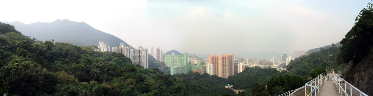

Chai Wan
Chai Wan means firewood bay, and for centuries that unglamorous name captured everything about this place: a bay on the eastern tip of Hong Kong Island where people cut wood, hauled water, and passed through on the way to somewhere more important. At the beginning of the 18th century it was six villages. By the time the MTR arrived in 1985, it was the end of the line — literally the eastern terminus of the Island line — and one of the most densely built corners of the city.
Six Villages and a Fort
In the early 1700s, Chai Wan consisted of six distinct villages — Dai Ping Village, Law Uk, Luk Uk, Nam Uk, Sai Village, and Sing Uk — each with its own character. By 1845 the British military had built a fort and barracks at Siu Sai Wan on the eastern edge. The area's real war-era tragedy came in December 1941, during the Japanese invasion that became the Battle of Hong Kong. At the Sai Wan Battery, approximately 20 gunners were executed despite having already surrendered. They are buried at Sai Wan War Cemetery on Mount Collinson, one of a cluster of cemeteries on that hillside that includes Catholic, Muslim, Buddhist, and Chinese permanent cemeteries — a quiet, elevated reminder of the different communities that have lived and died at this end of the island.
The Bay Fills In
Chai Wan today sits largely on reclaimed land — the bay that gave it its name gradually filled to make room for a city that had no other direction to expand. The reclamation pushed the shoreline outward, creating the flat coastal platform on which Heng Fa Chuen now stands. When that residential estate was developed jointly by MTR Corporation and Kerry Properties, construction began on 13 August 1977 and the development officially opened on 10 July 1982. Its 6,504 apartments spread across 48 residential blocks, with a shopping centre attached and an MTR depot buried beneath the first 18 blocks. The working name for the station had been "Chai Wan Quay"; it became Heng Fa Chuen when MTR took on the development role.
Flight Paths and Height Limits
There is a curious detail hidden in the rooflines of Heng Fa Chuen's towers: almost none of them exceed 20 floors. The reason is Kai Tak Airport, the old runway that extended into Kowloon Bay on the north side of the harbour. Heng Fa Chuen sat beneath the flight path of aircraft landing on Kai Tak's southern approach, and height restrictions kept the towers low. Those restrictions shaped the skyline for decades. In 1989, the world's 11,000th McDonald's restaurant opened in the development's shopping centre — an oddly specific piece of corporate geography that lodged itself in local memory. Kai Tak closed in 1998, replaced by Chek Lap Kok Airport to the west, and the height limits eventually became moot.
What the End of the Line Preserves
The Law Uk Folk Museum, in a restored 18th-century village house that is now a branch of the Hong Kong Museum of History, survives as a physical trace of the six original villages. Inside, the domestic life of a Hakka family is preserved — the tools, the layout, the proportions of rooms built for a way of living the city absorbed long ago. Siu Sai Wan at the far eastern edge holds the largest sports ground on Hong Kong Island and the Island Resort private housing estate, housing around 80,000 people in a development that barely existed before the 1990s. Mount Collinson and Pottinger Peak rise to the south, limiting expansion and keeping a sliver of green between the city and the sea. At the eastern terminus of the Island line, Chai Wan still feels like the end of something — the city running out of island.
From the Air
Chai Wan is located at 22.27°N, 114.24°E at the eastern tip of Hong Kong Island. From the air at 2,000–4,000 feet, the dense residential towers of Heng Fa Chuen are clearly visible along the reclaimed waterfront, with the green hills of Mount Collinson and Shek O Country Park rising behind them. The Lei Yue Mun channel separates the area from Kowloon to the north — a narrow strait that marks the eastern entrance to Victoria Harbour. Nearby ICAO airport: VHHH (Hong Kong International Airport) lies approximately 40 km to the west. On clear days, the distinct triangular headland of Cape Collinson is visible to the south.
Nearby Stories
- Lok Ma Chau Loop 2.3 km away
- Portas do Cerco 2.3 km away
- Kweilin Incident 17 km away
- Wanshan Archipelago Campaign 34 km away
- Nanxiong Formation 115 km away
- Battle of Nanpeng Island 148 km away
- Heyuan 169 km away
- Cape Maobitou 632 km away