Chapada dos Veadeiros National Park
There is a persistent rumor in the Brazilian mystic community that NASA once called Chapada dos Veadeiros the brightest point on Earth as seen from space. The theory: a massive bed of quartz crystal under the plateau reflects sunlight back into orbit like a mirror. NASA has never actually said this. Satellites measure brightness as reflectivity, and Antarctic ice fields easily outshine any savanna. But the story persists because the land feels like it could be true. The sun here is fierce, the air is dry, and the rocks really are studded with quartz. On a clear afternoon at Vale da Lua, sunlight hits the river-polished stone and the canyon walls seem to generate their own light. Whether that is geology or something else depends on who you ask.
High Cerrado
Chapada dos Veadeiros National Park protects 240,586 hectares of high cerrado at the northern edge of Goiás state - a quartzite plateau rising above 1,000 meters, one of the oldest landscapes in South America. UNESCO added it to the World Heritage list in 2001, pairing it with nearby Emas National Park to represent the Cerrado's biological diversity. The name means Plateau of the Deer, a reference to the pampas deer and swamp deer that once roamed the grasslands in herds. The park was established in 1961, originally with an area seven times its current size; subsequent reductions have trimmed it repeatedly, often to accommodate ranching and mining interests at the plateau's edges. The surviving park preserves rivers that cut down through the quartzite in canyons hundreds of meters deep, finishing in waterfalls that drop into pools clear enough to see the sandy bottom from the lip.
Sao Jorge and Alto Paraiso
Two towns frame the park. Sao Jorge sits right at the entrance - a village without asphalt streets or public lighting, a deliberate preservation of rustic character meant to keep artificial night light from disrupting the park's wildlife. Candles and generators do the job. Alto Paraiso de Goiás, 20 kilometers away, is the administrative center: regular roads, restaurants, pousadas, and services. Alto Paraiso means High Paradise, and the name attracts the mystic community that has made the plateau one of Brazil's New Age capitals. Crystal shops line the main street. Yoga retreats occupy the surrounding cerrado. Some visitors come for UFO sightings, which locals report with a casualness that suggests either a rich tradition or a rich joke. Alto Paraiso sits on the 14th parallel south, and visitors arrive convinced they can feel the latitude.
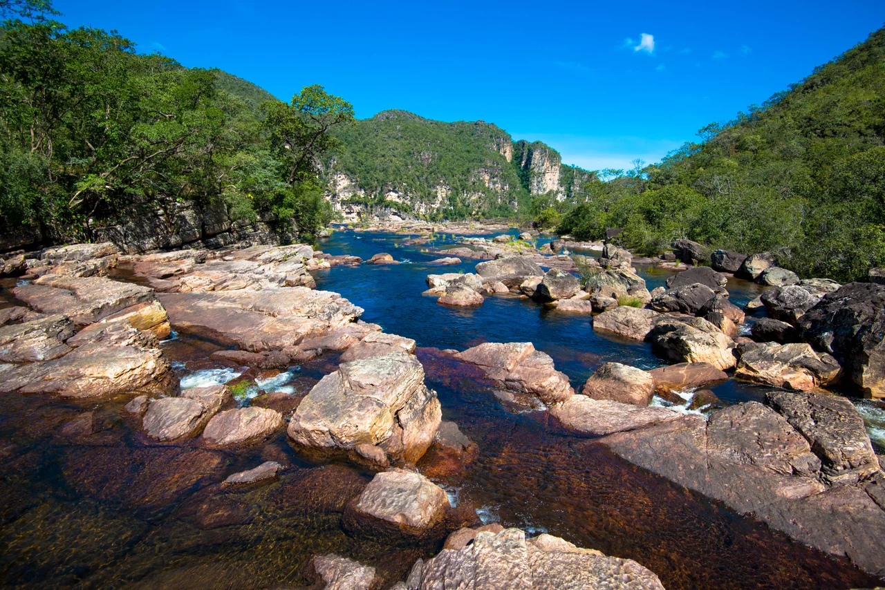
The Waterfalls
The park offers two authorized trails from the Sao Jorge entrance: the Way of the Canyons and the Way of the Falls. Both require a licensed local guide - groups of up to 10 people pay about R$100 for the guide fee, plus individual park admission. The Canyons trail descends into a gorge carved by the Rio Preto and reaches a series of jade-green pools. The Way of the Falls climbs to Salto 120 - a 120-meter cascade that plunges off a quartzite cliff in two stages. Outside the park boundary, private properties charge separate entry fees to access Moon Valley (Vale da Lua), with its moonlike eroded rock formations and swimming pools carved by the Sao Miguel River; Almecegas, Raizama, Sao Bento, Andorinha, and Segredo waterfalls, each with its own canyon and plunge pool; and the confluence of the Sao Miguel and Tocantinzinho rivers, where visitors let the current carry them downstream.
The Climate of the Plateau
Chapada's climate is tropical, hot, and semi-arid - an average annual temperature around 25 degrees Celsius, but with extremes in both directions. December through February brings the rainy season: daily downpours, waterfalls in flood, dangerous flash-flood conditions in the canyons. The park closes entirely during this period for visitor safety. After May, the rain ceases almost completely. A six-month dry season sets in, with September the hottest month - afternoon temperatures can hit 40 degrees. The best months to visit are June and July, when the waterfalls still run strong from the rains but the skies are clear and the trails dry. Yellow fever vaccination is recommended at least ten days before the trip. Tapirs, capybaras, giant anteaters, giant armadillos, and maned wolves share the park with jaguars that still hunt the edges, though visitors rarely see them.
The Mystic Plateau
The crystal story does not come from nowhere. The quartzite rock that forms the plateau is rich in quartz - the park's name was the Park of the Deer, but it could as easily have been the Park of the Stones. Souvenir shops in Sao Jorge sell rough quartz points, amethyst clusters, and hand-carved pendants of stones dug from nearby claims. Some of it is real and ethically sourced; some is imported to meet demand. The UFO phenomenon is more mysterious. Locals report lights over the plateau on clear nights, often associated with the Morro da Baleia formation or the cliffs above Vale da Lua. The rational explanation - satellites, meteor showers, high-altitude aircraft, auroras visible at southern latitudes during strong solar activity - satisfies most observers. But in a landscape this old, this strange, and this removed from the cities, the unexplained has room to breathe. The cerrado here is older than rumor, and it will outlast this one too.
From the Air
Located at 14.08 degrees south, 47.67 degrees west, on the Planalto Central plateau in northern Goiás. The park sits at 1,000-1,600 meters elevation. From the air, look for the quartzite plateau rising above surrounding cerrado, cut by deep canyons running southeast. Nearest airport: Brasília International (SBBR), 230 km to the south. No airport serves the park directly. Best flying weather June to August. Park closed to visitors December through February for the rainy season.
Nearby Stories
- Cavalcante 22 km away
- Niquelândia 33 km away
- Minaçu 40 km away
- Monte Alegre de Goiás 74 km away
- Posse, Goiás 80 km away
- Mambaí 108 km away
- Mara Rosa 110 km away
- Planaltina, Goiás 116 km away