Choiseul Island (Lauru)
The people who live on this 2,971-square-kilometer island in the northwest Solomons have always called it Lauru. The Spanish who glimpsed it in 1568 called it San Marcos because they saw it on Saint Mark's Day. The French called it Choiseul in 1768 to flatter a foreign minister who never came closer than Versailles. The Germans claimed it in 1884 and traded it to the British in 1900. The Japanese held it from 1942 to 1943. In 1978 it became part of an independent Solomon Islands. Through all those names and flags, the Lauru people kept their own word for their own place - and on the island itself, Lauru is still the name most often heard.
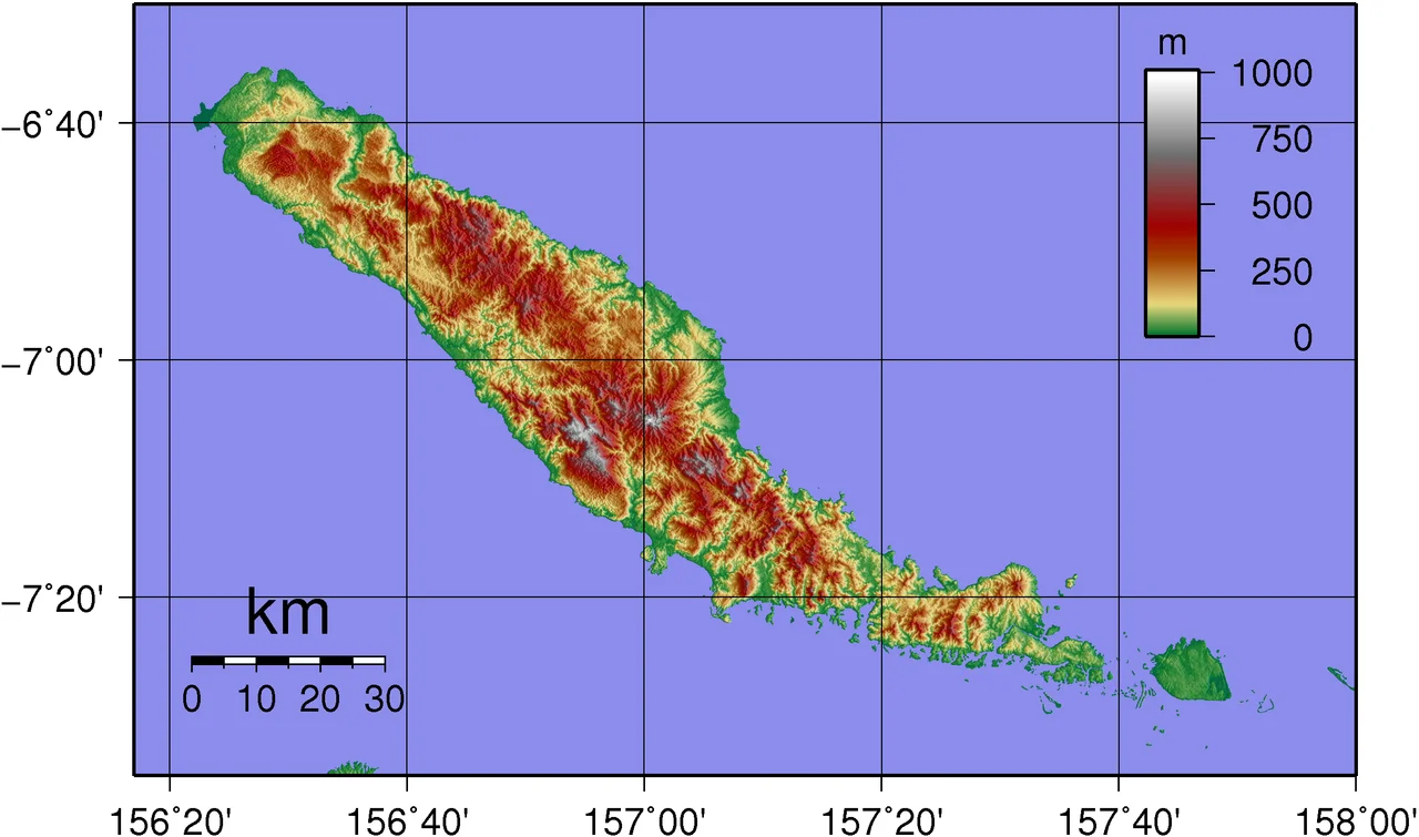
The Shape of the Place
Choiseul is the largest island in Choiseul Province - a long, mountainous sliver of land stretching roughly northwest to southeast, 2,971 square kilometers of rainforest and reef. In its interior rises Mount Maetambe, an extinct volcano whose flanks pour down into a limestone country of caves and subterranean rivers. The 78,398-hectare Mount Maetambe - Kolombangara River Important Bird Area preserves the best example of karst limestone forest anywhere in the Solomons. Water cuts through the eroding stone, vanishing underground and surfacing again as unexpected springs. The ridges are tangled with vines, epiphytes, and tree species you will not find outside this island chain. The coast is fringed with mangroves and coconut groves, the interior with a forest canopy that has sheltered the Lauru people for perhaps three thousand years.
Names Imposed and Kept
The first outsiders to see the island came from Peru. In April 1568, a brigantine called Santiago, commanded by Pedro Ortega Valencia with Hernan Gallego as pilot, broke off from Alvaro de Mendana's expedition and charted this coast. They called it San Marcos. Two centuries later, the French navigator Louis Antoine de Bougainville sailed past in 1768 and renamed the island after Etienne Francois, duc de Choiseul - the foreign minister who had funded the voyage. Neither name displaced Lauru. Mendana never set foot on the island he renamed. Bougainville named a place from his quarterdeck. The people who lived there went on living there, going on calling it what their ancestors had called it. That stubbornness - quiet, continuous, unrecorded in any European log - is its own form of history.
A Century of Taking
The nineteenth century brought the ships of the blackbirders. Labour recruiters - or kidnappers, depending on how honest the language gets - sailed the Solomons hunting workers for the sugar plantations of Queensland and Fiji. Some Lauru men and women went by agreement. Many were taken by deception or by force. Families lost sons and daughters to plantations a thousand miles away, some who returned years later with stories, and some who did not return at all. In 1884 the German Empire declared the northern Solomons a protectorate. In 1900, under the Tripartite Convention with Britain and the United States, Germany handed Choiseul to the British in exchange for a free hand in Samoa. Missionaries followed the flags. Methodists, Catholics, and Seventh-day Adventists established churches, schools, and clinics, and most Lauru people were eventually baptized into one denomination or another. Coconut planters from Britain and Australia carved estates out of the coastline.
Bernatzik's Photographs
In 1932 an Austrian anthropologist named Hugo Bernatzik arrived on Choiseul convinced he was witnessing the last of something. He photographed the islanders, documented ceremonies and customs, and took a carved stone urn home with him as an artifact of what he called a dying culture. His book appeared a few years later, illustrated with portraits of people whose faces are grave and composed in the way people become when a stranger has been pointing a camera at them. Bernatzik was wrong about the dying part. Lauru culture did not disappear. It changed, as all living cultures change - absorbing new religions, new languages, new economies - but the people in those photographs were not the end of anything. Their grandchildren still live on the island, still fish the same waters, still tell some of the stories he recorded and some he never heard.
A Raid, and a Gift of Birds
In October 1942 Japanese forces occupied the northwest coast. In October and November 1943 a battalion of US Marines led by Lieutenant Colonel Victor Krulak carried out a diversionary raid on Choiseul, burning supply dumps along the Voza coast to draw Japanese attention away from the main landing at Cape Torokina on Bougainville. The raid succeeded as a feint. Most Lauru villagers kept out of the fighting's way. When the war ended, the island went quiet again, and the forest kept its birds. Mount Maetambe shelters some of the strangest: Solomons cockatoos, black-faced pittas, song parrots, Sanford's sea eagles circling the ridgelines, and deep in the forest the Solomons frogmouth - a bird so elusive that for decades it was known mostly from a single specimen collected in 1901 and only rediscovered alive by ornithologists in the 1990s. The Choiseul crested pigeon, however, did not survive European contact. It was last seen in 1904 and has not been found since.
From the Air
Choiseul Island is centered near 7.0 degrees south, 156.97 degrees east, oriented roughly northwest-southeast across about 145 kilometers of the western Solomons. Recommended viewing altitude: 5,000-7,000 feet to appreciate the mountain spine, the karst country of the interior, and the reef-fringed coast. The nearest airport is Choiseul Bay (AGGC) on Taro Island, the provincial capital, with a short unsealed runway. Honiara's Henderson Field (AGGH/HIR) is about 300 nautical miles to the southeast. Expect tropical cumulus by midafternoon and frequent squalls in the November-April wet season.
Nearby Stories
- Japanese Seaplane Carrier Nisshin 33 km away
- Battle of Vella Lavella (naval) 40 km away
- Japanese cruiser Jintsu 49 km away
- Japanese submarine Ro-100 54 km away
- Bougainville Copper Limited 168 km away
- Païta 1913 km away
- Maré Island 1970 km away
- 1737 Kamchatka Earthquake 6583 km away