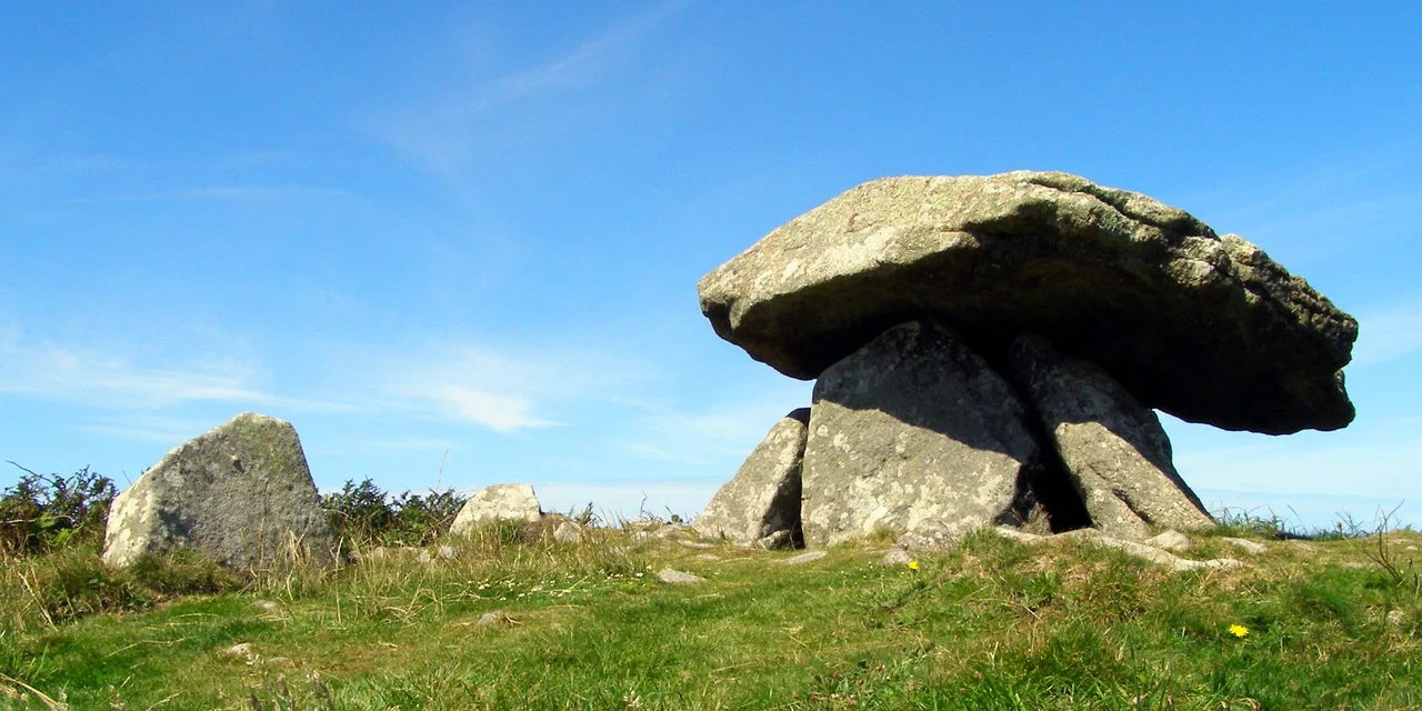

Chun Quoit
Four men, possibly six, raised the capstone of Chun Quoit around 2400 BC. They had no metal tools to work with. Bronze was still centuries away, iron a full two millennia further off. They cut and shaped granite using granite, hammered slab against slab, dressed the great mushroom-domed top stone until it was 11 feet long and 10 feet wide and just under three feet thick at its centre. Then they propped it on four upright slabs, levered it into position perhaps seven feet off the ground, and walked away. Forty-four centuries later the capstone is still sitting where they put it. Every other quoit in West Penwith has fallen at some point and been re-erected by Victorian antiquarians or modern conservators. Chun Quoit never moved.
A House for the Dead
Quoits, also called dolmens or cromlechs, are Neolithic burial chambers, the surviving stone heart of structures that originally sat under earth mounds. Chun Quoit was once covered by a round barrow some 35 feet in diameter; the chamber inside, sealed by the great capstone, would have held the bones of the community's important dead, perhaps placed there over generations and shuffled around between burials. There is evidence of an entrance passage to the southeast leading into the mound, the route by which mourners carried the dead and later carried out the cleaned bones. The mound itself is largely gone, eroded into the moor, but enough remains to confirm the original form. The cup mark carved into the top of the capstone is harder to explain. Cup marks appear on Neolithic stones across Britain and Ireland. Nobody is entirely sure what they mean.
The Standing Stones of Penwith
Chun Quoit is one node in a dense Neolithic landscape. Within a few miles lie Lanyon Quoit, Mulfra Quoit, Men-an-Tol with its famous holed stone, and Men Scryfa with its early-medieval inscription. The rocky outline of Carn Kenidjack, a granite tor a couple of miles to the south-west, marks the point where the midwinter sun sets when viewed from Chun. The alignment is too precise to be accidental. Across West Penwith, the people who built these monuments laid them out in conversation with the sun and the horizon, marking the turning points of the year on the ground. Chun Quoit sits on its ridge facing the Celtic Sea, with the moor rolling away beneath it, and four thousand years ago a community gathered here to watch the year reach its shortest day and then begin its slow climb back toward summer.
Two Millennia Before the Castle
Chun Quoit predates the great Iron Age ringfort of Chun Castle, 800 feet to the east, by two thousand years. The Iron Age builders who raised those concentric walls in the fourth century BC arrived at a hilltop that already had a sacred monument on it, already had stories attached to it, already had ancestral significance for the local people. The quoit was old to them, the way the medieval cathedrals are old to us, and they built their fort with the older monument inside its sphere of influence. This is a common pattern in Cornish prehistory and elsewhere across Atlantic Europe. Each new wave of people did not erase the sacred geography they inherited. They added their own structures to it, layering centuries on millennia.
Old Denbras the Hurler
The folklore around Chun has its own version of the past. The Giants of Towednack records a tradition that the castle on Morvah Downs was once held by a giant named Old Denbras, called the Hurler for his skill at throwing stones in the wrestling games. Denbras was killed in a wrestling match by a young farmer named Tom, who inherited his lands on the condition that he bury the giant on his favourite seat on the hill, facing out to sea. The story tells how Tom and his wife Joan gathered stones all night and raised a barrow over the body, then placed the great quoit capstone above the giant's head, hiding him forever from the light of day. The story is roughly the right shape. A giant burial, a stone roof, a careful orientation toward the sea. The Cornish villagers who told it had no archaeological tools, but they understood quite well what they were looking at, and they kept the memory of it alive in the only way available to them: as a story about a wrestling match.
From the Air
Located at 50.1486°N, 5.6377°W on a ridge of open moorland near Pendeen and Morvah, 800 feet (about 250 m) west of Chun Castle. Best viewed from 1,000-2,000 feet AGL approaching from the south. Nearest airport: Land's End (EGHC), 4 nautical miles south. From the air the quoit appears as a small dark mushroom-shaped silhouette on the moorland ridge, with Chun Castle's circular earthworks immediately east. The Celtic Sea opens north and west. On clear days, Carn Kenidjack's distinctive rock outcrop is visible to the south-west; the midwinter sun sets behind it as viewed from the quoit, a relationship the Neolithic builders almost certainly knew.
Nearby Stories
- Bartholomew Ledges Wreck 1.8 km away
- Carn Brea Castle 4.6 km away
- Battle off Lizard Point 12 km away
- Carnewas and Bedruthan Steps 18 km away
- King Charles's Castle 25 km away
- MV Cita 34 km away
- 1979 Fastnet Race 47 km away
- Trevose Head Lighthouse 55 km away