Coachella Valley
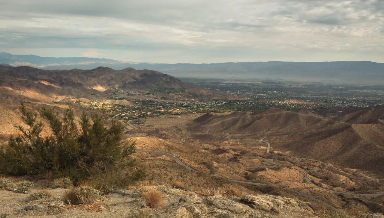
The Coachella Valley runs about forty-five miles from the San Gorgonio Pass at its northwest end to the Salton Sea at its southeast terminus, dropping from above 1,000 feet elevation at the pass to below sea level at the sea. The mountains on both sides rise more than 10,000 feet above it. Wind turbines crowd the pass entrance, the most concentrated wind power geography in the state. Below them, resort cities, date groves, golf courses, and agricultural fields cover a valley floor that gets about three inches of rain per year and sees temperatures above 110°F regularly each summer.
Before the Railroad and the Resort
The Cahuilla people inhabited the valley for thousands of years, using its mountain canyons for summer shade and the valley floor's artesian water — discovered by later settlers to be abundant beneath the surface — for agriculture. Edward Fitzgerald Beale surveyed the region in 1857 using a party that crossed the desert with camels, testing whether the animals could serve as military transport in the Southwest. The Southern Pacific Railroad arrived later in the nineteenth century, and the discovery of artesian wells made sustained habitation economically viable for more settlers. U.S. Route 99 came through in 1926, and State Highway 111 followed in the early 1930s, completing the transportation infrastructure that opened agriculture, commerce, and tourism to the rest of the country.
Dates, Wind, and $600 Million in Crops
The valley produces nearly 95 percent of American dates — a crop introduced in the 1890s when the USDA imported date palm shoots recognizing that the region's extreme heat and alkaline soil matched the conditions of the Middle East and North Africa where dates had been cultivated for millennia. The Riverside County Fair and National Date Festival in Indio celebrates this agricultural identity each February with camel racing and date-food competitions. The San Gorgonio Pass at the valley's northwest entrance is the second windiest place in the country; the thousands of wind turbines of the San Gorgonio Pass Wind Farm are among the first things visible to anyone driving in from the Los Angeles Basin. Total agricultural production in the valley exceeds $600 million annually.
The Valley That Hollywood Came to Rest In
The Coachella Valley became a Hollywood retreat in the 1930s when Charles Farrell and Ralph Bellamy founded the Racquet Club of Palm Springs — drawing Humphrey Bogart, Judy Garland, Fred Astaire, Ginger Rogers, Mary Pickford, and others who needed somewhere warm and close to the studios. Bing Crosby founded the Blue Skies Trailer Park in Rancho Mirage, famous for expensive trailers each designed with its own theme. Frank Capra worked on screenplays at La Quinta. The celebrity connection continued through subsequent decades and shaped Palm Springs into one of the most architecturally documented mid-century modern cities in America — a catalog of post-war optimism built in the desert for people who could afford to escape it.
Music, Tennis, and the Annual Gathering
The Coachella Valley Music and Arts Festival has taken place on the polo grounds of Empire Polo Club in Indio each April since 1999, growing into the highest-grossing music festival in the United States. Stagecoach Country Music Festival follows on the same grounds. The BNP Paribas Open tennis tournament at Indian Wells has reached an attendance of nearly 500,000 in a two-week period — the best-attended tennis event outside the four Grand Slams — at a stadium with 16,100 seats, the second largest permanent tennis facility in the world. The valley's capacity to host mass gatherings reflects a combination of consistent weather, abundant land, and infrastructure built initially to serve the resort economy.
From the Air
The Coachella Valley runs roughly northwest-to-southeast from the San Gorgonio Pass (approximately 33.93°N, 116.93°W) to the Salton Sea (approximately 33.2°N, 115.8°W). The valley floor is easily identifiable from altitude as a flat, irrigated expanse surrounded by mountains exceeding 10,000 feet on the southwest (San Jacinto, 10,804 ft) and north (San Gorgonio, 11,503 ft). The San Gorgonio Pass Wind Farm at the northwest entrance is a distinctive visual landmark — thousands of turbines are visible on the hillsides on either side of Interstate 10. Primary airports: Palm Springs International (KPSP, serving the western valley), Jacqueline Cochran Regional Airport (KTRM/TRM, serving the eastern valley, 115 ft below sea level). The valley's orientation creates a natural wind corridor; expect turbulence near the pass and on the downwind sides of mountain ridges.
Nearby Stories
- Mountain Fire (2013) 4.8 km away
- Lost Horse Mine 5.3 km away
- Niland Geyser 15 km away
- Thomas L. "Pegleg" Smith 15 km away
- Chocolate Mountains 23 km away
- Cadiz Dunes Wilderness 27 km away
- San Pasqual Band of Diegueno Mission Indians 31 km away
- San Bernardino Train Disaster 62 km away