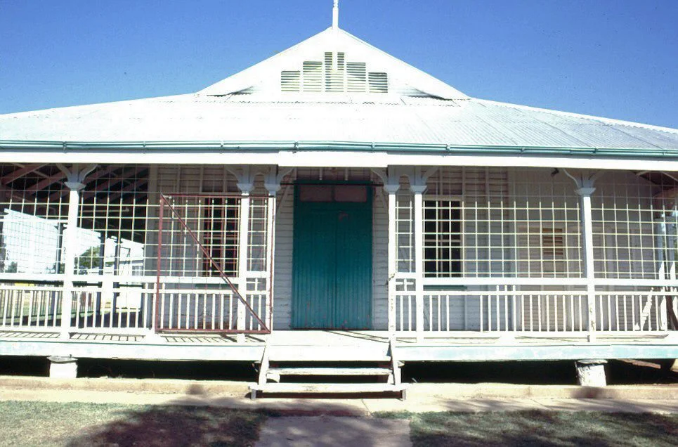

Community Hall, Camooweal
Every town needs a room big enough to hold itself. In Camooweal - a speck on the Barkly Highway, seven miles short of the Northern Territory and a long, hot drive from anywhere - that room is a single-storey timber hall with verandahs running all the way around. Since 1923 it has been the place where the district gathers: for weddings and funerals, dances and concerts, church services and council meetings, and on polling day, to vote. Its pressed-metal ceilings and copper honour rolls have watched a century of the town's life pass beneath them. In country this empty, the Community Hall is more than a building - it is the social glue that lets a scattered population feel like a community at all.
A Town Built on a Stock Route
Camooweal exists because of where two roads meet. Surveyed in 1883 and gazetted as a town the following year, it grew up at the junction of the Georgina stock route and the road into the Northern Territory - then controlled by South Australia. Its position was its fortune. Midway between Burketown and Cloncurry and just seven miles from the colonial border, it became a vital supply centre and, in the years before Federation, a customs post collecting duty on goods crossing between separate colonies. By 1892 the town had a court, police station, two hotels, a school, and a string of supply businesses. For a wide and lonely district, Camooweal was the place you came to buy what you needed and hear what was happening.
Shire Chambers on the Border
When the Barkly Tableland Shire was carved out of the Burke and Cloncurry shires in 1914, Camooweal sat at its centre, and the new local authority needed a home. The hall was built in 1922–23 on a government reserve at the corner of Nowranie Street and the Barkly Highway, alongside the police, court house, and health blocks - the town's administrative heart. The Townsville firm of Rooney Brothers drew the plans; Hogarth and Hammond won the job with the lowest tender, helped by a Queensland Government loan to be repaid over ten years. From the start it was both council chambers and gathering place. The local hospital was given free use of the hall for entertainments and the office for its monthly meetings - a practical generosity typical of small outback towns.
Honour Rolls and Hard Times
The hall carries the memory of the men this district sent to war. In 1924 an ornate honour board - copper mounted on timber, made by the firm Wunderlich - was installed to remember those who served in the First World War; pressed-copper honour rolls still hang on the east wall today. By 1935 the building had grown too small for a rising population, so the Shire applied for another government loan, this time deliberately structured to create work for the unemployed during the Depression. Rooney Brothers were sent the original plans and asked to design an extension to match, adding thirty feet to the hall and a residence for the shire clerk. The hall grew, but it grew faithfully - each addition keeping to the spirit of the first.
Built for the Heat, Built to Last
The hall is a lesson in how to build for an arid climate without machinery to cool it. Wide verandahs encircle the timber building on its low stumps, shading the walls; French doors open onto them to draw a breeze straight through; timber louvres enclose the southern side. The gambrel roof is clad in corrugated iron, and inside, the ceilings are sheeted in decorative pressed metal. During the Second World War the world briefly came to Camooweal - the Barkly Highway was sealed for supply convoys and the town became an important refuelling stop, its airfield pressed into service. Through it all the hall kept doing its quiet work. Restored for the town's centenary in 1984 and again in 1993, it remains exactly what it was built to be: the room where Camooweal becomes itself.
From the Air
Located at 19.92°S, 138.12°E, on the Barkly Highway in the centre of Camooweal, about 13 km east of the Northern Territory border. From the air the hall reads as a corrugated-iron roof among a small grid of streets on the flat, pale plain beside the Georgina River. Camooweal Airport (YCMW/CML) sits barely half a nautical mile north-east of town; the nearest major airfield is Mount Isa Airport (YBMA/ISA), roughly 165 km east along the highway. The land is open and remote - the Barkly Highway itself and the Georgina River channels are the main navigation cues. Dry-season skies (May–September) give the clearest viewing.
Nearby Stories
- Riversleigh World Heritage Area 74 km away
- Barkly Tableland 77 km away
- George Fisher mine 107 km away
- Lake Moondarra 131 km away
- 1964 Mount Isa Mines strike 165 km away
- Brunette Downs Station 197 km away
- Marqua Station 288 km away
- Tennant Creek 344 km away