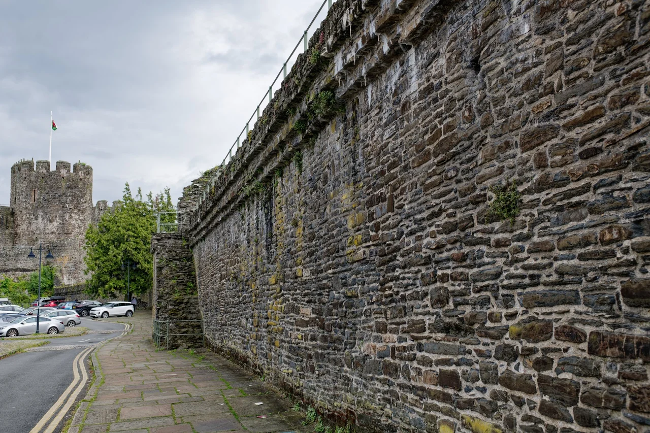

Conwy Town Walls
Walk the circuit and you can do something almost no other town in Europe allows: walk continuously on the wall-walk of a complete medieval fortification, one kilometre and three hundred metres around, looking down on a small town that has been living inside the same walls for seven hundred and forty years. There are twenty-one towers. There are three original gatehouses. There is a stretch with twelve medieval latrines built into the stone, the only such survival of its kind, originally for the use of the royal staff working in the buildings inside. Above all there is the fact that Conwy's town walls do not feel like a ruin or a monument. They feel like what they are: a working piece of the town's daily life, threaded through with houses and shops and gardens, the survival of an Edwardian act of colonial engineering that was, by the testimony of the historians who study such things, 'one of the most impressive walled circuits' in Europe.
1283: dispossession and design
Before the walls there was an abbey. Aberconwy, the Cistercian foundation favoured by Llywelyn the Great and his successors, had stood on the river bank since the late twelfth century. In March 1283, three months after the death of Llywelyn ap Gruffudd ended Welsh independence, Edward I arrived with a colossal army and decided this would be the centre of a new English county. The monks were moved eight miles upriver to Maenan. The town that replaced them was a deliberate colonial enterprise: built on the high-status site of a Welsh dynastic abbey to demonstrate, in stone, who now ruled north Wales. The street plan stretched away from the river in a T-shape, the castle anchoring one corner of the T - a layout shared with the other Edwardian foundations at Caernarfon, Harlech, Beaumaris, and Flint. English settlers, mostly from Cheshire and Lancashire, were brought in to fill the new houses. Welsh residents were viewed with suspicion for generations.
Master James and the building seasons
The walls went up alongside the castle under the overall supervision of Master James of Saint George, Edward's chief architect in north Wales. Each summer thousands of labourers were mobilised from across England, mustered at Chester, and marched into Wales for the building season. The first phase in 1283 was preparatory: ditches and a wooden palisade to secure the site for stonework. The stone walls and twenty-one towers went up in three phases. Between 1284 and 1285 Richard the Engineer - Master James's second in command - built the western side, the most vulnerable approach. In 1286 a Savoyard mason named John Francis finished the south wall. In 1287 Philip of Darley closed the circuit along the eastern quay. The total bill for castle and walls together came to around fifteen thousand pounds - an extraordinary sum for the period, comparable to a substantial military campaign.
1401: the sack
In April 1401, on Good Friday, two of Owain Glyndŵr's cousins infiltrated Conwy Castle while most of its garrison were at the parish church. They took it. Despite the great circuit of walls outside, Welsh forces then occupied the town for two months and sacked it. The townspeople later claimed five thousand pounds' worth of damage, including the destruction of the gates and the bridges along the walls. The seizure was a coup in the early phase of Glyndŵr's rebellion against English rule - a humiliation for the crown that took serious effort to undo. After the Tudors came to the throne in 1485 the political pressure that had sustained the walls eased. Welsh-English hostilities lessened, the military purpose of the defences declined, and the townspeople began using the wall ditches as rubbish dumps. Stone was robbed for other buildings.
Telford, Stephenson, Cadw
The nineteenth century brought new threats and unexpected respect. Thomas Telford built his suspension bridge across the Conwy in 1826, designing the bridge's stone towers to match the castle, and cutting two new gateways through the walls to carry the traffic. In 1848 Robert Stephenson drove his Chester-to-Holyhead railway through the south side, and - unusually for the railway age - the company built a mock-Gothic archway to keep the wound from looking too brutal. The walls were architecturally surveyed for the first time between 1928 and 1930. In 1953 the Ministry of Works took on a lease from the local authority and began a serious conservation campaign: clearing the houses that had grown against the walls since the fourteenth century, demolishing one of Telford's intrusions in 1958, and giving the historian Arnold J. Taylor decades to study them. In 1986 the walls were inscribed as part of the UNESCO World Heritage Site 'Castles and Town Walls of King Edward in Gwynedd.' Today they are managed by Cadw.
What you see today
The east side runs four towers from the castle to the quay, with a postern gate and the Lower Gate giving access to the harbour. The west side, nine towers strong, climbs the hill toward the south-west corner. One merlon up there still wears its original stone finial - a small detail that was once standard along the whole circuit. The south side, eight towers and two gatehouses, includes the surviving Upper Gate, the medieval main inland entrance, which still keeps part of its stone barbican - a rare survival. Just inside the south wall sit the remains of Llywelyn's Hall, originally built into the wall by Edward I and dismantled in 1316 to be moved to Caernarfon Castle. The twelve medieval latrines built into the south wall, for royal staff in the adjacent buildings, are unique. When the walls were new the historical record says they were 'daubed' - possibly whitewashed - so a thirteenth-century traveller approaching Conwy would have seen a circuit of dazzling pale stone, not the weathered grey-brown of today.
Flight Context
Conwy Town Walls form a closed irregular polygon on the west bank of the Conwy estuary at 53.281 north, 3.831 west. From the air the circuit is a clear stone outline enclosing the medieval street grid, with the castle anchoring the south-east corner above the river. Best viewed at 1,500 to 2,500 ft AGL flying south down the Conwy estuary. Nearest airports: Caernarfon (EGCK) twelve miles west, RAF Valley (EGOV) on Anglesey, Hawarden (EGNR) east toward Chester.
From the Air
53.281°N, 3.831°W. 1.3 km closed circuit on the west bank of the Conwy estuary. Best viewed at 1,500-2,500 ft AGL. Nearest airports: EGCK Caernarfon, EGOV Valley, EGNR Hawarden.
Nearby Stories
- Caldy 1 km away
- Moelfre, Anglesey 1.2 km away
- Pen-yr-Orsedd Quarry 2.5 km away
- Ysbyty Ifan 7.5 km away
- Birkdale Palace Hotel 9.5 km away
- Wrexham County Borough Museum 12 km away
- Celtic Array 22 km away
- Southport Lifeboat Station 45 km away