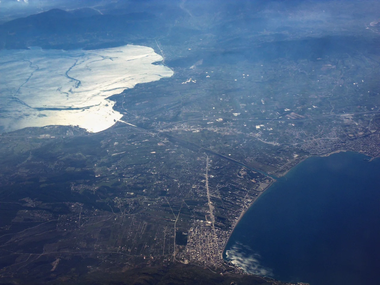

Corinth Canal
In 67 AD, the Emperor Nero broke ground on the Corinth Canal with a golden pickaxe, ceremonially removed the first basket of soil, and put 6,000 workers to work cutting trenches from both ends of the isthmus. The workforce consisted of prisoners captured during the First Jewish-Roman War — men who had been transported from their homeland to dig a trench through a Greek hillside at the order of a Roman emperor. Nero died the following year. The project stopped. The trench sat open for 1,800 years. When the engineers who built the modern canal arrived in 1881, they discovered Nero's trenches still there and reused the same exploratory shafts to probe the rock. The modern canal follows the same course Nero had planned. It opened in 1893. The canal that everyone wanted, that kept killing its advocates before they could finish it, was finally dug — and immediately started falling apart.
Two Thousand Years of Trying
The idea of cutting through the Isthmus of Corinth is old enough to be attributed to Periander, the tyrant of Corinth, in the 7th century BC. He looked at the project and decided it was too expensive, too ambitious, and too risky — fearing the canal would undercut Corinth's role as a trading hub. Instead he built the Diolkos, a stone trackway across the isthmus on which ships could be hauled overland on wooden rollers, saving them the 700-kilometre voyage around the Peloponnese. Remnants of the Diolkos are still visible next to the modern canal. Demetrius Poliorcetes considered the canal around 300 BC but abandoned the plan when his surveyors wrongly calculated that the seas on either side were at different levels and warned of catastrophic flooding. Julius Caesar contemplated it. Caligula commissioned a study in 40 AD from Egyptian engineers who also miscalculated the sea levels. Then came Nero, who actually started digging — and who understood, correctly, that the Ionian and Aegean seas are at the same level. He was right about the engineering. He was less fortunate about the timing.
Six Thousand Judean Prisoners and a Pickaxe
The labour force Nero assembled for the canal project deserves to be remembered by name, though history has not preserved those names. The 6,000 Judean prisoners of war who dug the trenches in 67 AD were captives from the First Jewish-Roman War — people whose homes had been destroyed, whose communities were under military assault, and who were transported across the Mediterranean to perform forced labour on an imperial vanity project in a country that was not their own. They worked in two groups cutting from each end of the isthmus, while a third group on the ridge drilled exploratory shafts to assess the rock. The shafts, cut with the tools and labour of people who had no choice in the matter, were still useful to the 19th-century engineers who found them 1,800 years later and dropped measuring lines into them. The canal was eventually built. The people who started it are largely forgotten, absorbed into the impersonal category of 'Roman workforce.'
Built at Last, and Immediately Troubled
The modern canal's construction history is its own saga of ambition, bankruptcy, and engineering difficulty. After Greek independence in 1830, the statesman Ioannis Kapodistrias tried to revive the project but abandoned it when the estimated cost — 40 million gold francs — proved far beyond the means of the new state. The opening of the Suez Canal in 1869 provided fresh momentum, and in 1882 construction was formally inaugurated in the presence of King George I of Greece. The French company that started the work went bankrupt — linked to the same financial collapse that had destroyed the first Panama Canal company. A Greek company took over in 1890 and completed the work on 25 July 1893. Almost immediately the problems began. The limestone walls were unstable from the start; the wake from passing ships undermined them further. Before the canal could open to navigation, landslides blocked it. More than 165,000 cubic metres of masonry were used to line the walls. Between 1893 and 1940, the canal was closed for a total of four years for emergency maintenance. In 1923 alone, 41,000 cubic metres of material fell into it and took two years to clear.
A Scar Through the Isthmus
The canal as it exists today is a single lock-free channel 6,343 metres long, 24.6 metres wide at the surface and 21.3 metres at the bottom, with limestone walls rising 90 metres above sea level at a near-vertical 80-degree angle. No other waterway in the world looks quite like it: a clean geometric cut through solid rock, the walls pale and banded with geological strata, the strip of sea below impossibly narrow. Ships pass through in single file, one convoy at a time; larger vessels must be towed by tugs because there is no room to turn. During World War II, German forces destroyed the main bridge in a glider-borne assault on 26 April 1941 and later, retreating in 1944, dumped locomotives and bridge wreckage into the channel to block it. The US Army Corps of Engineers cleared the canal by 1948. Landslides closed it again at the start of 2021; it reopened seasonally in June 2023, closed again in October 2023 for further restoration, and fully reopened in May 2024. The canal is now primarily a tourist attraction — too narrow for most modern cargo ships, but still capable of inducing vertigo in anyone who walks across one of the bridges and looks straight down.
From the Air
The Corinth Canal lies at approximately 37.93°N, 22.98°E, cutting through the narrow Isthmus of Corinth at the northeastern edge of the Peloponnese. From the air it is one of the most striking geographical features in all of Greece: a straight, narrow incision through the land, linking the blue of the Gulf of Corinth to the northwest with the Saronic Gulf to the southeast. The limestone walls and the thin line of water between them are clearly visible from several thousand feet. The nearest major airport is Athens International (LGAV / Eleftherios Venizelos), approximately 65 km to the east. Recommended viewing altitude: 2,000–3,500 feet AGL to see the full length of the cut, the bridge crossings, and the contrasting bodies of water on either end.
Nearby Stories
- Stymfalia 3 km away
- Sanctuary of Asclepius, Epidaurus 4.6 km away
- German Submarine U-133 (1941) 5.9 km away
- Battle of the Trench (1821) 6.7 km away
- 1981 Gulf of Corinth Earthquakes 12 km away
- Aigeira 13 km away
- Agios Thomas, Boeotia 14 km away
- Agios Georgios (island) 36 km away