
Cornubian Batholith
Almost everything that has happened in Cornwall in the last 4,000 years can be traced to a slab of granite that nobody can see. Two hundred and eighty million years ago, deep beneath what would become southwest England, vast volumes of molten rock crystallized and cooled. That granite is still there. It is the reason Dartmoor and Bodmin Moor exist as wind-scoured uplands. It is the reason china clay pits scar the country around St Austell. It is the reason Cornwall mined tin and copper for the world. The exposed outcrops at Dartmoor, Bodmin Moor, St Austell, Carnmenellis, Land's End and the Isles of Scilly are the visible knuckles of a single buried giant: the Cornubian batholith.
A Buried Giant
A batholith is a vast mass of intrusive rock, magma that cooled slowly below the surface and crystallized into granite. The Cornubian batholith stretches from about 8° West, more than 100 km southwest of the Isles of Scilly, all the way east to the edge of Dartmoor. You can measure it through gravity, because granite is less dense than the rocks around it, so the pull of gravity dips slightly above the batholith's footprint. Geophysicists map it as a long, narrow gravity low, trending west-southwest to east-northeast, parallel to the buried Haig Fras granite further out at sea. The volume was estimated in 1989 at around 68,000 cubic kilometres of granite. The exposed parts are only the hilltops of this submerged monolith.
Born of a Mountain Range That Vanished
The batholith was born during the Variscan orogeny, a mountain-building event that lasted from about 380 to 280 million years ago, when continents collided to form the supercontinent Pangaea. The mountains that rose then, somewhere in the rough position of present-day southern England, were comparable to the Alps. They eroded away. What remained were the cores: hot blobs of magma that had risen into the lower crust. Stretching of the crust at the very end of the Variscan, between roughly 300 and 275 million years ago, gave the magmas room to climb. Isotope chemistry shows they were mostly the result of melting sedimentary rocks deep in the crust, with a minor mantle contribution. The earliest dated intrusion is the Carnmenellis pluton at 293 million years; the youngest is the southern lobe of the Land's End granite at 274 million. Twenty-five million years of separate magma bodies fused into one underlying mass.
The Tors and the Clitter
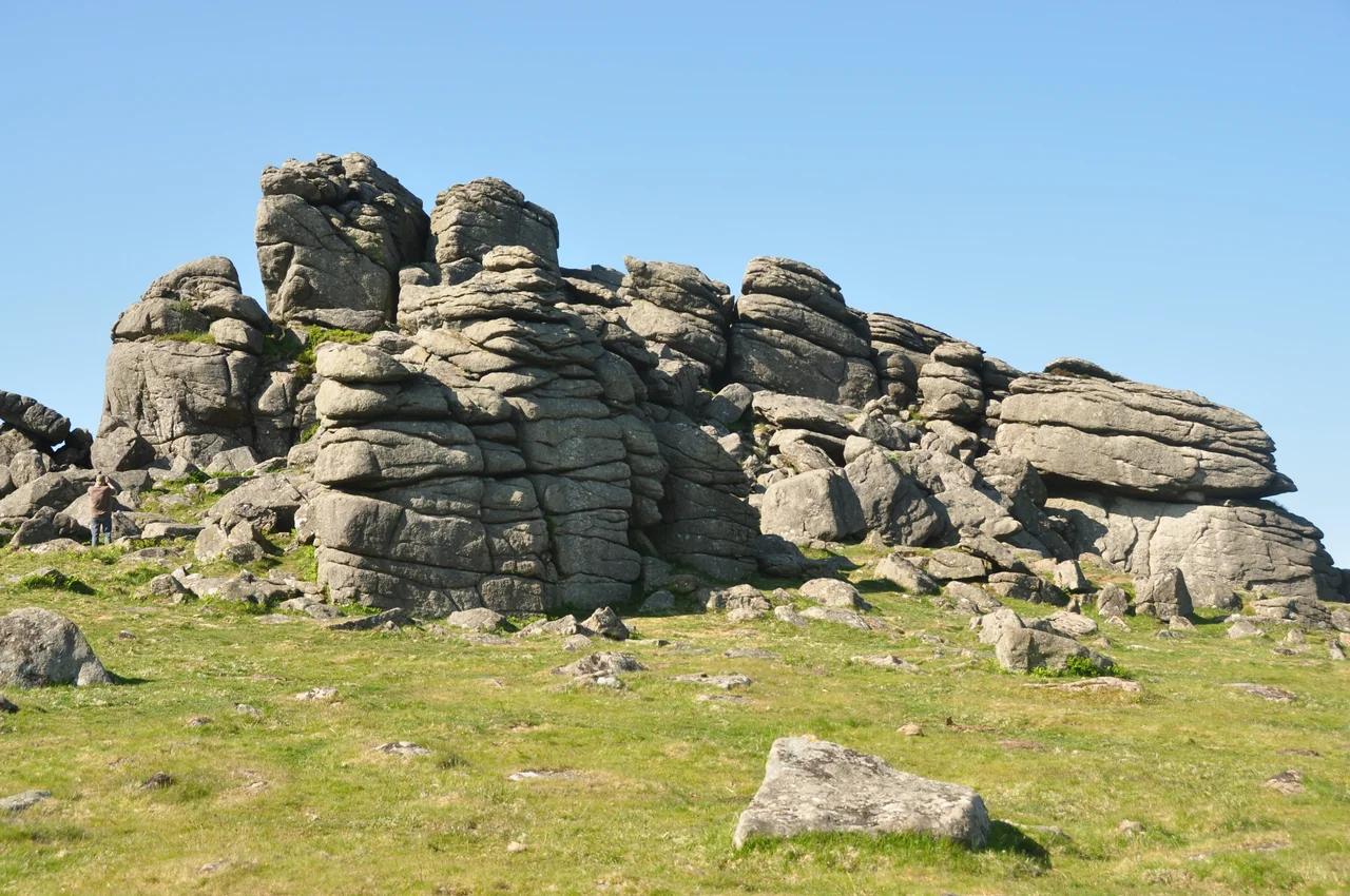
When the granite cooled, fractures formed: vertical joints first, then horizontal joints as the rock expanded toward the surface. Over the millions of years that followed, the softer slates and sandstones above were stripped off by erosion. The granite emerged. Where the joints were widely spaced, the granite stood up as tors, those characteristic stacks of weathered blocks you see crowning Dartmoor, Bodmin Moor, and the high ground above Carn Brea. Where the joints were closer together, the granite broke down into loose blocks called clitter that tumble down the slopes. Cornwall's moors and uplands have the bald, bouldered look they do because of these joint geometries, set when the granite was still cooling 280 million years ago.
The Metals Came Later
The granite itself is interesting; what came out of it changed history. As the batholith cooled, hot fluids rich in volatile elements escaped along fractures. They picked up tin, copper, lead, zinc, tungsten, arsenic, lithium, boron and other elements, and deposited them in veins running through both the granite and the surrounding country rock. Cassiterite, the ore of tin, was concentrated enough to be mined from around 2000 BC. Roman traders knew the Cornish tin trade. So did Phoenician merchants. The Camborne-Redruth-St Day district became one of the richest copper fields in the world during the 19th century, supplying the wire and sheathing that electrified an empire. The granite around the plutons was baked into hornfels by contact metamorphism, with garnet, amphibole and pyroxene crystallizing in a four-mile aureole around each intrusion.
China Clay and the White Pyramids
There is one more product of the batholith that left a different kind of mark. In the St Austell district and at Lee Moor on the western edge of Dartmoor, the feldspar in the granite was altered by circulating warm water late in the cooling history, kaolinized into china clay. This was the raw material for porcelain, paper coating and a hundred other industries. The clay was extracted by hydraulic mining, blasting hillsides apart with high-pressure water jets, which left enormous white spoil heaps that locals still call the Cornish Alps. From the air, the satellite image of southwest England shows these as pale scars in the green country around St Austell. They are the still-visible evidence of a granite that crystallized at 770 degrees Celsius and 50 megapascals of pressure, in a Permian world where Britain was still tropical and the Atlantic Ocean had not yet opened.
From the Air
The Cornubian batholith underlies most of Cornwall and Devon. The reference point for this article (50.20°N, 5.20°W) sits over the Carnmenellis granite, one of the major exposed plutons, between Helston, Falmouth and Camborne. From cruising altitude in clear weather the granite uplands read as patches of higher, rougher, brown-green land contrasting with the lower farmed country: Dartmoor as a high plateau in eastern Devon, Bodmin Moor as a lump in north Cornwall, and the smaller domes of Carnmenellis and Land's End in the far west. The white china clay pits around St Austell are conspicuous as pale scars on the satellite view. Nearest airports are Newquay (EGHQ) over the Carnmenellis flank to the north, Land's End (EGHC) on the westernmost granite, and Plymouth (EGHD) southeast of Dartmoor. Cruise at 4,000-6,000 feet to take the full extent of the Permian granite spine in one sweep.
Nearby Stories
- Morvah 2.9 km away
- Carnewas and Bedruthan Steps 6.1 km away
- Liskeard 7.5 km away
- Battle off Lizard Point 14 km away
- Polperro 17 km away
- MV Cita 47 km away
- HMS Affray 86 km away
- 1979 Fastnet Race 96 km away