D'Entrecasteaux Islands
Something extraordinary is happening under these islands, and it is happening fast. The gneiss domes that form the cores of Goodenough, Fergusson, and Normanby are made of rock that was buried nearly 100 kilometers below the Earth's surface just five million years ago - rock that should be lost to the mantle, that should be locked down in the deep heat of the planet, and that has instead been rising back toward daylight at a rate of about 20 millimeters a year. Geologists come here to see stones that a continent is currently giving back. And on the surface, above all that tectonic drama, three large islands and a cluster of smaller ones spread across 160 kilometers of the Solomon Sea, home to people whose ancestors learned to read ocean currents before anyone in Europe had learned to read at all.
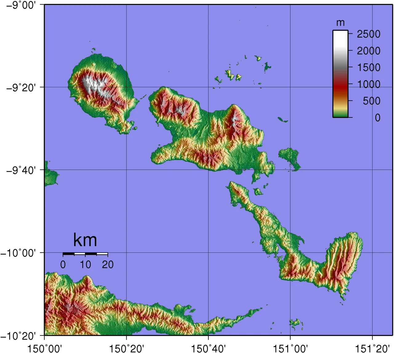
Three Islands in the Sea
The archipelago sits just off the eastern tip of New Guinea, separated from the mainland by the 30-kilometer-wide Ward Hunt Strait to the north and the 18-kilometer-wide Goschen Strait to the south. The three large islands line up from northwest to southeast: Goodenough (Nidula) first, then Fergusson (Moratau) across Moresby Strait - the biggest of the three - and then Normanby (Duau) across Dawson Strait. Together they total about 3,100 square kilometers of land. The smaller islands and islets scattered among them include Dobu, a volcanic cone of a place that has exerted an outsized influence on the culture and history of the whole group. Hot springs bubble at Deidei on Fergusson. Volcanic cones stud the Dawson Straits between Fergusson and Normanby, and one of them - on southwestern Fergusson - may have erupted as recently as 1350. The islands sit at the leading edge of the Woodlark spreading center, a ridge propagating westward into the continent, prying New Guinea open along a seam that geologists can map but not yet fully explain.
Rocks From the Depths
The technical name for the youngest rocks here is coesite-eclogite. Coesite is a form of silica that only forms under pressures higher than two gigapascals - pressures that exist only deep in the Earth. The eclogite here was cooked at temperatures above 700 degrees Celsius and pressures that correspond to depths around 100 kilometers. Zircon crystals inside this rock have been dated by thermal ionization mass spectrometry. Their age is about five million years. Do the arithmetic and the rate at which this material has risen through the Earth works out to roughly 20 millimeters a year - which does not sound fast until you remember what it is describing. Most of the time, rock buried that deep stays buried. Here it has come back. The gneiss domes that form the spines of Goodenough and Fergusson are the exposed cores of that uplift, wearing the shattered remnants of their overlying crust like carapaces draped over a shoulder. Geologists call these islands one of the world's best natural laboratories for the study of continental breakup in progress.
Canoes and Shell Valuables
The Kula ring is one of the most celebrated exchange systems in anthropology, and the D'Entrecasteaux Islanders have been part of it for as long as anyone can trace. Men built sea-going sailing canoes with careful attention to hull and spirit - the canoes were not just vessels but living things, capable of carrying a trader safely across open water to the Trobriands, to Woodlark, down to the Louisiades. They carried red shell-disc necklaces called soulava in one direction and white armshells called mwali in the other, the two kinds of valuables moving in opposite circuits around a ring that took in half a dozen island groups. A canoe voyage was not just a commercial trip. It was ceremonial, dangerous, regulated by spells and protocols that a generation of anthropologists has spent careers trying to describe. The people of the archipelago also traded clay pots for yams with the Trobrianders, who have the island sand but not the island clay. This kind of specialized production and exchange gave each island community a reason to stay in touch with the others. The Kula ring still functions today, in reduced form, carrying its valuables along sea routes that predate every colonial map.
The Naming Voyage of 1792
In 1792, the French navigator Antoine Bruni d'Entrecasteaux sailed these waters aboard his flagship Recherche, searching for the missing expedition of Jean-Francois de Galaup, the Comte de La Perouse, whose ships had vanished in the South Pacific four years earlier. D'Entrecasteaux never found La Perouse, whose wreckage would not be identified until decades later on the reef at Vanikoro. But he sighted a string of mountainous islands off the eastern tip of New Guinea, made notes and charts, and moved on. The islands kept their local names - Nidula, Moratau, Duau - for the people who lived on them. On European charts they acquired the name of the captain who had passed through. In 1874 Captain John Moresby of the Royal Navy made the first European landfall, running a coastal survey of the west coasts. By the 1890s missionaries were arriving, first the Methodists on Dobu under William Bromilow, then Catholics and others. With them came recruiters for copra plantations and gold mines, and the centuries-old trade routes began to change shape to accommodate new demands.
When the War Came and Went
For a brief time during the Second World War the archipelago sat in the middle of the Pacific campaign. A US Navy PT-boat base opened on Fergusson Island in June 1942. Japanese marines got themselves stranded on Goodenough in August 1942 and were eventually pushed off by Australian troops. In 1943, RAAF mobile works squadrons built a 6,000-foot airstrip at Vivigani on Goodenough, and from June 1943 through August 1944 it served as a staging point for Allied operations further west. Then the war moved on. The runways became commercial airfields - Vivigani is still in service, open to scheduled flights since 1963. The foxholes filled with leaves. The islanders resumed their own pace. Today the population continues to live much as before: subsistence horticulture, trade between islands, some cash income from copra and trochus shell and small-scale mineral work. Beneath them, the gneiss domes keep rising. The Woodlark ridge keeps propagating. The islands are, in a sense, still being born.
From the Air
Located at 9.65 degrees south, 150.7 degrees east, just off the eastern tip of Papua New Guinea in the Solomon Sea. The three main islands - Goodenough, Fergusson, and Normanby - form a distinctive northwest-to-southeast chain spanning 160 kilometers. Recommended viewing altitude 8,000 to 12,000 feet to appreciate the full archipelago and the narrow straits separating each island. Mount Vineuo on Goodenough (2,536 meters) is the highest point. Vivigani Airfield (ICAO AYGN) on Goodenough is the main strip; Losuia on Kiriwina (ICAO AYKI) lies to the north in the Trobriands. Watch for convective buildup over the gneiss-dome peaks in the afternoon; morning flights offer the clearest views of the hot-spring field at Deidei on Fergusson.
Nearby Stories
- Ss Peter and Paul Cathedral, Dogura 28 km away
- Normanby Island (Papua New Guinea) 49 km away
- Milne Bay Province 76 km away
- Trobriand Islands 79 km away
- Tufi 92 km away
- Woodlark Island 177 km away
- Misima Island 195 km away
- Louisiade Archipelago 269 km away