_Topography.png)
Normanby Island (Papua New Guinea)
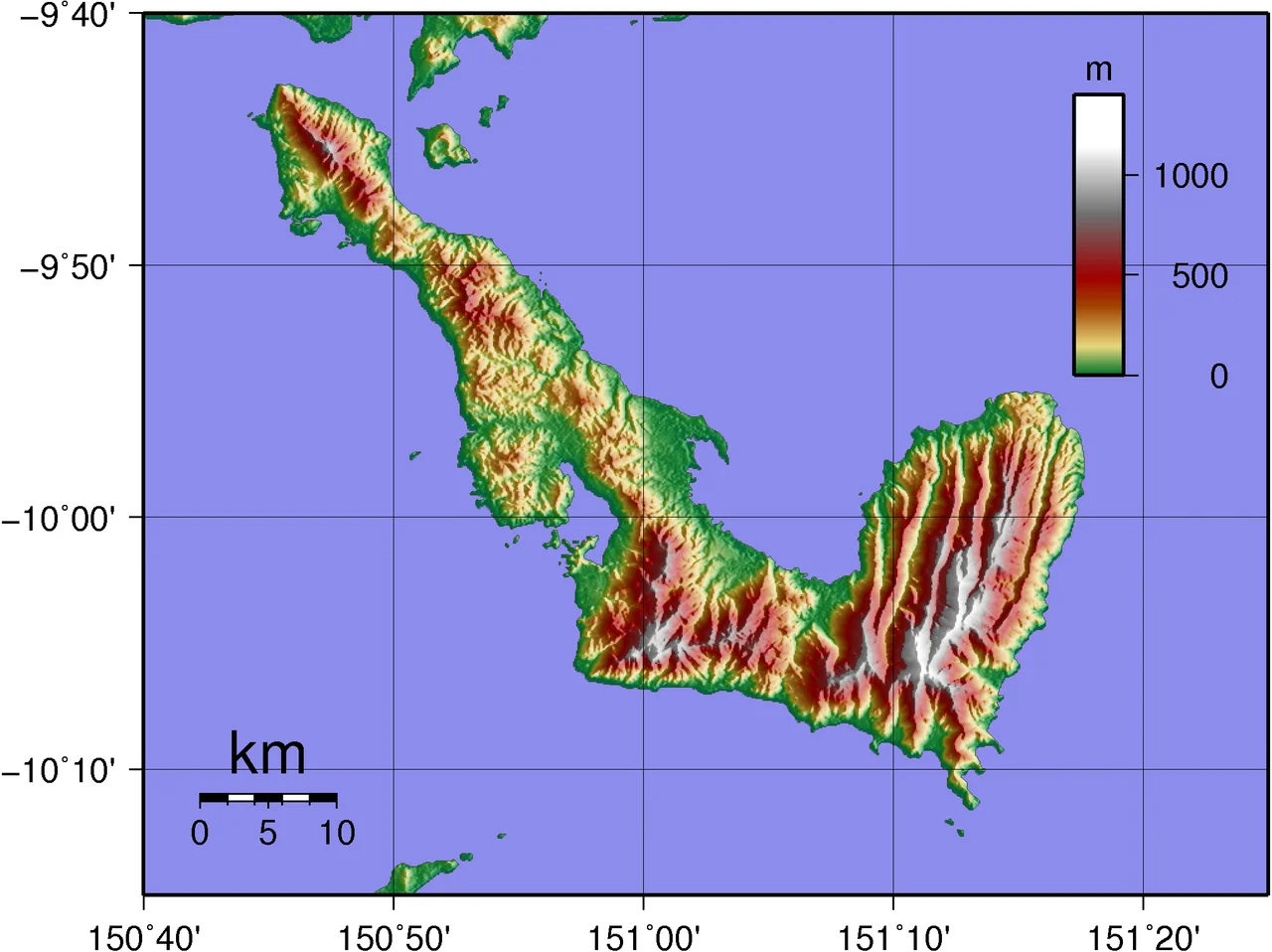
The shape of Normanby Island on a map makes no particular sense until you see it from altitude, when the wide L becomes obvious - seventy-three kilometres long, volcanic, folding itself against the eastern end of New Guinea across a narrow strait. Mountains take up most of the interior. The Prevost Range climbs to 1,158 metres in the southeast, steep and jungled, and underneath it sits enough gold to have drawn a Canadian mining company back in the early twenty-first century. Along the coast the island is ringed by villages of raised wooden huts whose inhabitants have lived on this land for thousands of years, speak a language called Duau, and still participate in one of the most famous ceremonial exchange systems in the anthropological literature. The island is the southernmost of the D'Entrecasteaux group, and the people who live here almost never think of it as named after an obscure Victorian-era British peer. They think of it as home.
What John Moresby Called It
In 1873 the British naval officer John Moresby, in command of HMS Basilisk, was charting the eastern end of New Guinea for the Admiralty. The Basilisk ran up against the D'Entrecasteaux Islands - which had been named eighty years earlier by a French captain after his own admiral - and Moresby got to naming things himself. For this largest southern island he chose Normanby, honouring George Augustus Constantine Phipps, the 2nd Marquess of Normanby. Phipps was then serving his second term as Governor of Queensland, the Australian colony whose parliament and merchants were paying a great deal of attention to New Guinea. This is the kind of imperial naming that happened across most of the Pacific in the nineteenth century: large islands, rich with their own settlements and languages and histories, being rechristened on board ships for politicians in distant countries who would never see them. The inhabitants of Normanby spoke the Austronesian language Duau then, and they still do. They never stopped.
The Kula Ring
What Normanby is perhaps most famous for, in the academic world, is its place in the Kula exchange - the ceremonial trade that links Normanby and the other islands of the Massim archipelago to the Trobriands, Woodlark, and beyond. The anthropologist Bronislaw Malinowski spent most of the First World War documenting it, producing Argonauts of the Western Pacific in 1922, which became one of the founding texts of modern ethnography. In the Kula, men travel hundreds of kilometres by canoe to exchange two categories of ceremonial valuables: red shell-disc necklaces that circulate clockwise around the ring, and white shell-armbands that circulate counter-clockwise. An object's value lies in where it has been, who has held it, and the history it has accumulated, not in any intrinsic material worth. A Normanby man with a famous Kula necklace has something no amount of money can buy. The exchange is still active. A 2025 anthropological study described it as "a meshwork," a continuing living practice, not a museum piece - thousands of individuals across dozens of islands, crossing open water in outrigger canoes to maintain relationships whose logic Western economics cannot quite describe.
Gold and Copra
Nineteenth-century prospectors came to Normanby looking for gold and found some. By the twentieth century the rushes had moved elsewhere and the island settled into copra and timber - the standard Melanesian coastal economy, coconuts dried in the sun and shipped out, hardwood cut from the interior and loaded at the jetties. Then in the 2010s a Canadian company called PNG Gold Corp began drilling at the Imwauna Project Site on the southern flank of the Prevost Range, and the exploration hits came back strong. High-grade intercepts, the mining press reported, bodies of gold that had presumably been sitting in the volcanic rock for millions of years while the island above them grew, aged, hosted Kula traders, was mapped by the British, gained an airfield, and lost one. Whether a significant mine ever reaches production on Normanby is still, as of the mid-2020s, an open question. What is not open is that tourism, copra, timber, and gold now make up the island's four-legged economy, each doing just enough to keep the communities on the shoreline intact.
Living Along the Edge
Most of Normanby's residents live along the shoreline, in small close-knit villages of raised wooden huts built from trees cut nearby. There are at least twenty-five settlements on the island with more than five houses, and hundreds of smaller homesteads and gardens scattered inland. The two main towns are Esa'ala at the north end and Sehulea to the southeast. Esa'ala is the capital of the Esa'ala District and holds about five hundred homes and buildings; it is the commercial centre, such as it is. Both settlements have airstrips - Esa'ala's is a dirt runway 1.36 kilometres long, Sehulea's is 830 metres of unpaved surface - and both get occasional small aircraft flights from Alotau on the mainland. There are no roads connecting most of the villages on the island. Between settlements, people still move the way their great-grandparents did, by foot along coastal paths or by canoe along the reefs. Cruise ships sometimes pass offshore, their passengers photographing the coast through long lenses; the scene from the water is essentially what it would have been in 1873, when Moresby first sighted it, minus the British gunboat.
The View From Above
From the air Normanby shows most clearly what the ground rarely reveals: the clear L-shape of the island, the deep Dawson Strait (known locally as the Dobu Passage) that separates it from Fergusson Island to the north, the narrow 2.5-kilometre channel that puts the smaller volcanic Dobu Island off its western coast. Dobu itself, tiny and cone-shaped, is the site of some of the Kula's most important ritual centres; its reputation for sorcery was once legendary across the Massim. Normanby's own interior is a tangle of mountain and swampland, low coastal plains rising fast to steep slopes covered in rainforest, with Sewa Bay offering shelter on the west coast and Awaiara Bay on the east. The Prevost Range makes its own weather, pulling in afternoon clouds that drop hard tropical rain back into the valleys that feed the streams that cross the coastal belt. Seen from cruising altitude on a clear morning, the island is green and precise, its shape distinct against the paler reef waters around it - a piece of Melanesia that has absorbed whatever was thrown at it for millennia and remained, quite recognisably, itself.
From the Air
Located at 10.067S, 151.033E, the southernmost of the D'Entrecasteaux Islands, about 16 km north-east of East Cape on the New Guinea mainland, separated by Goschen Strait. The island is L-shaped, 73 km long, rising to 1,158 metres at Mount Prevost in the Prevost Range. Two airports: Esa'ala Airport (ESA) with a 1.36 km dirt runway at the north end, and Sehulea Airport (AYSL) with an 830 m unpaved runway at the southeast. Gurney Airport (GUR/AYGN) at Alotau, about 40 nautical miles west-southwest, is the regional hub. Dobu Island sits off the western side across a 2.5 km passage. Afternoon convective weather common; best seen in morning clear air when the L-shape and the Prevost Range are unmistakable against the reef waters.
Nearby Stories
- Alotau 24 km away
- D'Entrecasteaux Islands 39 km away
- Samarai 45 km away
- Goodenough Island 58 km away
- Misima Island 138 km away
- Woodlark Island 159 km away
- Louisiade Archipelago 202 km away
- Cod Hole 707 km away