Goodenough Island
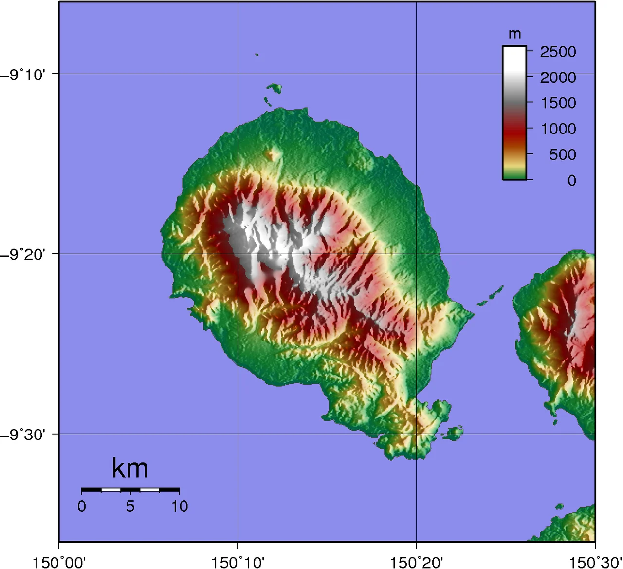
The island is nearly a circle on the map - 39 kilometers across, 687 square kilometers of land floating in the Solomon Sea - and from that circle rises Mount Vineuo, 2,536 meters of jungled slope climbing so sharply that Goodenough counts among the most precipitous islands on the planet. The coast is a thin apron of grassland and mangrove. The summit is rainforest shrouded in cloud. Between them lie the villages where 20,000 people live and speak four Austronesian languages, and above 1,100 meters the mountain simply doesn't carry human settlement at all. The peak belongs to the waterfalls that pour down its flanks, feeding the streams that thread the coastal plain.
The Many Names of the Island
The people who have lived here for thousands of years - relations of mainland Papuans who arrived so long ago that the archaeology is still being written - call the place Nidula. That is its real name, and it is the name spoken in Bwaidoga, Iduna, Diodio, and Wataluma, the four local languages that belong to the Milne Bay family. Bwaidoga became a regional lingua franca after Methodist missionaries adopted it at the turn of the twentieth century, but all four are still spoken in the villages that ring the shore: Bolubolu the administrative center, Wailagi with its United Church mission, Wataluma with its plantation, and a dozen others. The name Goodenough is the outsider's layer, pinned to the island in 1874 when Captain John Moresby, aboard HMS Basilisk, made the first European landfall and chose to honor a British naval colleague rather than ask what the place was called. Both names are still in use, which is itself a small record of who has been here and how they have related to the ground under their feet.
A Mountain That Hides Itself
Cloud forest cloaks the upper slopes of Mount Vineuo, and the mountain rewards the difficulty of reaching it. Rushing streams with waterfalls cascade down from the central peak. Rainforest gives way to secondary forest, which gives way to the grassland and garden plots of the coastal belt. Rainfall ranges from 1,520 to 2,540 millimeters a year, enough to keep everything green except during the droughts that arrive once or twice a decade. In the center of the island, the Oya Madawa Wildlife Management Area protects 22,840 hectares of this vertical world, home to the endangered black dorcopsis - the only wallaby known to be endemic to a Pacific island. Goodenough also holds a botanical rarity: Citrus wakonai, a wild edible citrus locally called kakamadu, a fruit whose tart flesh has kept quiet company with the island's gardens for generations. The mountain grows cooler as you climb. Tropical cyclones are rare here, but the northwest monsoon from December through March can unleash sudden rain squalls that turn streams into torrents in minutes.
The Japanese Marines of August 1942
On the night of August 25, 1942, seven motorized landing craft carrying 353 marines of the 5th Sasebo Special Naval Landing Force pulled into a bay at the southern end of the island. Commander Tsukioka's men were bound for Taupota on the mainland, where they were to take part in the Battle of Milne Bay. Goodenough was just a rest stop. The rest never ended. Kittyhawks of No. 75 Squadron RAAF found the boats in the morning and destroyed them, leaving the marines stranded on an island they had expected to leave. They dug in. They waited. Two months later, on October 22, the Australian warships HMAS Stuart and HMAS Arunta appeared with 640 soldiers of the 2/12th Battalion aboard. The Japanese held out briefly, then withdrew under cover of darkness to Fergusson Island and were eventually evacuated by submarine. For a few weeks in a vast Pacific war, a quiet tropical island had become a trap, and the trap had held.
Vivigani Airfield and Operation Cartwheel
An American engineer walked the coastal plain near a pre-war mission airstrip and recommended that a permanent 6,000-foot runway be cut from the grassland at Vivigani. By the middle of 1943, Goodenough had become one of the most active Allied staging points in the South West Pacific. A fighter strip opened June 15. By the end of July, 3,614 RAAF personnel were stationed on the island. The bomber strip came online in October. From Vivigani, Beauforts of No. 100 Squadron RAAF flew north to hammer Rabaul, the Japanese stronghold in New Britain, as part of Operation Cartwheel. Airmen lived in tents beneath the palms. Mechanics worked on aircraft in heat that made metal too hot to touch. Local people watched the war arrive and then, after August 1944, watched it leave as the front moved west. The runway at Vivigani survived its military moment and has handled commercial flights ever since 1963.
What Remains Under the Circle
Stand on a hilltop above Bolubolu today and you can see all of it at once - the thin coastal ring of gardens and coconut palms, the mountain rising into weather, the smaller Wagifa Island offshore to the southeast. The 2,536-meter summit often wears cloud like a hat. Subsistence gardens climb the lower slopes in patches, and fishermen work the reefs with canoes. The wreckage of the Japanese landing craft still lies offshore, slowly being reclaimed by coral. Vivigani's runway cuts across the northeast plain, its rusting revetments softened by grass. The four languages are still spoken in their villages. The kakamadu tree still fruits in the forest. And Mount Vineuo, having spent geological time pushing upward through New Guinea's tangled crust, still stands unroaded above the coast, its upper reaches still belonging to the waterfalls.
From the Air
Located at 9.37 degrees south, 150.27 degrees east, in the Solomon Sea east of mainland Papua New Guinea. Goodenough presents an unmistakable circular silhouette with Mount Vineuo rising to 2,536 meters at its center - often the highest cloud-capped peak visible for miles. Recommended viewing altitude 6,000 to 10,000 feet to appreciate the precipitous rise from sea level to summit. Vivigani Airfield (ICAO AYGN) lies on the northeast coastal plain; Gurney Airport in Alotau (ICAO AYGN-adjacent region AYGR) is the nearest major alternate. Westerly approaches show the Moresby Strait separating Goodenough from Fergusson Island. Expect tropical convective buildup over the summit in afternoons.
Nearby Stories
- Tufi 50 km away
- Normanby Island (Papua New Guinea) 50 km away
- Ss Peter and Paul Cathedral, Dogura 52 km away
- Trobriand Islands 56 km away
- Operation Chronicle 93 km away
- Japanese Submarine Ro-103 103 km away
- Kokoda Track 150 km away
- Kapa Kapa Trail 247 km away