Delta do Parnaíba Environmental Protection Area
Most of the world's great rivers reach the ocean through a single dominant channel. A few do something else. The Parnaíba, after draining 330,000 square kilometers of Brazil's northeast, shatters into a fan of distributaries that splay across 85 kilometers of coastline and pour into the open Atlantic through dozens of separate mouths. It is the only open-sea river delta in the Americas — one of only three such formations in the world — and the reason a 313,800-hectare federal protection area wraps around its edges, touching the coasts of Maranhão, Piauí, and Ceará in a single administrative embrace.
The Three-State Delta
The protected area covers parts of eleven municipalities across three states. In Maranhão: Água Doce do Maranhão, Araioses, Paulino Neves, Tutóia. In Piauí: Cajueiro da Praia, Ilha Grande, Luís Correia, and the regional capital of Parnaíba itself - the second-largest city in Piauí. In Ceará: Barroquinha and Chaval. The federal decree that created the APA on August 28, 1996, had to reconcile land-use traditions across three state bureaucracies and the centuries-old habits of fishing villages, salt extractors, and small farmers who pre-date any of the state lines. The Chico Mendes Institute for Biodiversity Conservation administers it now as an IUCN Category V protected landscape - a designation that allows continued human use rather than strict preservation. The management plan came out in 1998; the consultative council was seated in December 2007.
Where Three Biomes Converge
The delta lies at a biogeographic hinge. The thorny caatinga scrub of the northeast interior comes up against it from the east. The cerrado savanna arrives from the southwest. Marine systems push in from the north. Inside the protected zone, each meets the others: coastal caatinga, restinga forest on sandy substrate, mangrove along the tidal channels, and flood zones thick with the tall carnaúba palms whose waxy leaves once carried the regional economy. Biodiversity measures run unusually high. Endemic species crop up that exist nowhere else. Among the federally protected animals inside the APA are the red-handed howler monkey (Alouatta belzebul), whose rust-colored hands distinguish it from other howlers, and the smalltooth sawfish (Pristis pectinata), a critically endangered ocean predator that uses the brackish delta mouths as a nursery.
Dunes That Refuse to Stay Still
Stand on a dune at the inland edge of the Parnaíba delta and you can watch geology happen in real time. The interior fields run hundreds of square kilometers of mobile sand, oriented mostly northeast to southwest along the prevailing wind. Creepers and shrubs hold down some dunes. Others march. Tides, wind, river current, and recent movements of the crustal floor keep the whole system unstable. To the east, the Lençóis Maranhenses National Park - which adjoins the APA to the west - makes this dune geography famous, its white sand basins filling with rainwater to form thousands of turquoise lagoons each wet season. The delta's dunes are less photographed but follow the same logic: a landscape built by the wind and rewritten every year.
A Working Delta
This is not empty land. The APA exists, by its own charter, to improve the quality of life of resident populations through guided economic activities - not to clear them out. Small-scale fishing remains the core livelihood across the delta, carried out from the same kind of low, simple boats used for centuries. Jangadas still work the outer channels. The Delta do Parnaíba Marine Extractive Reserve, a more strictly regulated zone inside the broader APA, protects the traditional rights of those fishing communities. Threats persist. Aquaculture conversions - shrimp ponds in particular - have cleared patches of mangrove. Uncontrolled resource extraction chips away at the edges. Tourism is growing too, much of it focused on the town of Parnaíba, which now has daily flights from Fortaleza and Teresina alongside two weekly flights from Campinas. Balancing the three pressures - subsistence, conservation, tourism - is the institutional story of the Parnaíba delta in its fourth decade as protected land.
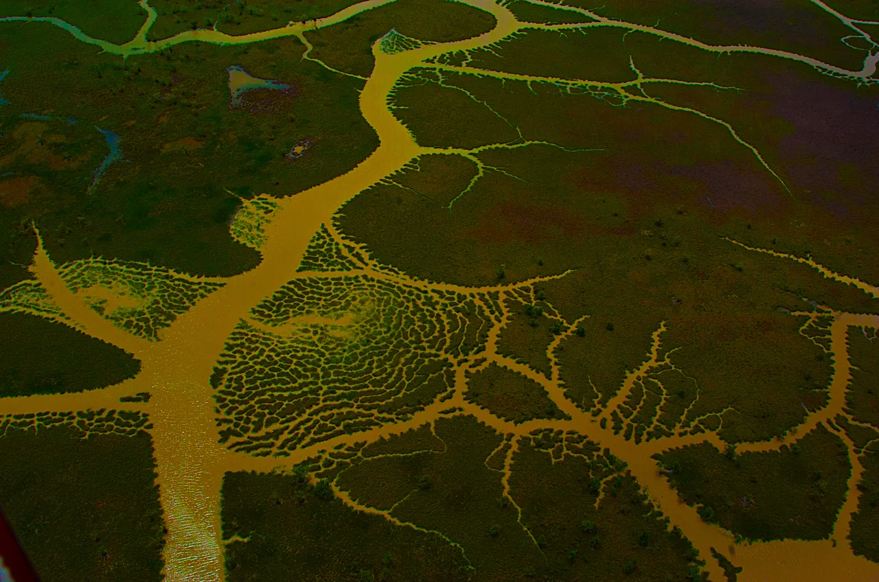
From the Air
Centered around 2.81°S, 41.81°W where the Parnaíba River splits into its distributaries. Total protected area 313,800 hectares (3,138 km²) spanning the borders of Maranhão, Piauí, and Ceará. Adjoins Lençóis Maranhenses National Park to the west. Best viewing altitude FL180-FL300 reveals the fan of channels and offshore islands, plus the interior dune fields. Nearest airports: Parnaíba (SBPB) directly at the delta, with daily flights from Fortaleza (SBFZ) and Teresina (SBTE). São Luís (SBSL) lies to the west. Weather: 80% of annual 1,200 mm rainfall January-May; dry August-November. Temperatures fairly constant 25-30°C year-round.
Nearby Stories
- Paulino Neves 38 km away
- Jericoacoara Beach 69 km away
- Tianguá 84 km away
- Ubajara National Park 121 km away
- Ilha de Santana Lighthouse 161 km away
- Chapada Limpa Extractive Reserve 181 km away
- German submarine U-164 (1941) 204 km away
- Alcântara Space Center 304 km away