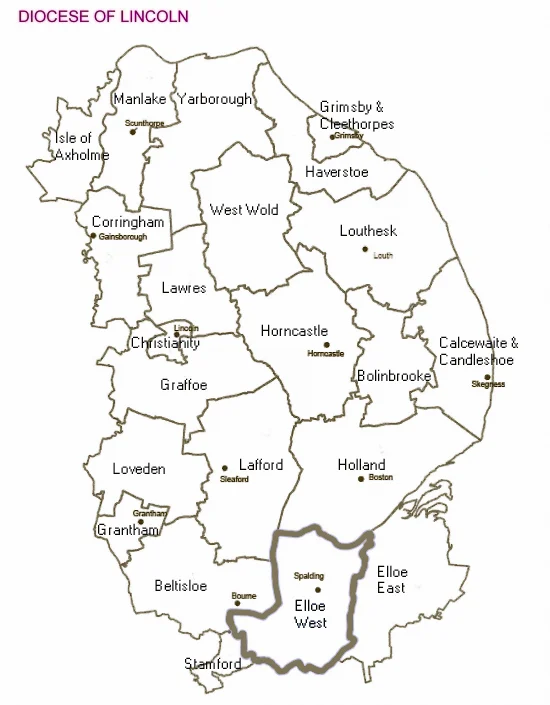

Diocese of Lincoln
There is a particular kind of grandeur in a thing that has been shrinking for nearly a thousand years and still refuses to apologise. When Remigius de Fécamp, William the Conqueror's chaplain and the first Norman Bishop of Lincoln, set up his see in 1072, he inherited a diocese that ran from the Humber Estuary in the north to the River Thames in the south - all the territory of the modern counties of Lincolnshire, Leicestershire, Rutland, Northamptonshire, Huntingdonshire, Bedfordshire, Buckinghamshire, and Oxfordshire, plus large parts of Hertfordshire. It was, by a wide margin, the largest diocese in England. Roughly nine hundred years of administrative slicing later, it covers Lincolnshire and not much else. A retired bishop once described it as "2,000 square miles of bugger all." He was being affectionate, in the way that only a Lincolnshire bishop can be.
Roots in a Saxon Bishopric
The diocese's origins lie not at Lincoln at all but at Leicester, where a bishop was first installed around 679 by Theodore of Tarsus, the great organising Archbishop of Canterbury. The Saxon see of Leicester was abandoned during the Viking raids of the 9th century and re-established at Dorchester-on-Thames, well to the south. There it absorbed the older Anglo-Saxon Diocese of Lindsey, which had covered the Lincolnshire wolds and fens. The territory just kept growing. By the eve of the Norman Conquest, this Dorchester-Lincoln see stretched across the centre of England. In 1072, six years after Hastings, the Conqueror's bishop Remigius decided that Dorchester was off-centre and Lincoln - well-placed at the junction of the great Roman roads, perched dramatically on its limestone hill, recently strengthened with a new castle - was the better headquarters. He transferred the see and began building Lincoln Cathedral. The vast medieval diocese was already in place. Remigius merely gave it the seat it would hold for centuries.
The Long Reach to the Thames
Because Lincoln's territory ran all the way to the Thames, the Bishops of Lincoln retained significant landholdings in Oxfordshire long after the medieval diocese began breaking up. The market town of Banbury - sitting on the very far south of their reach - remained a peculiar of the Bishop of Lincoln for centuries, an enclave administered from a hundred and twenty miles away. Lincoln College, Oxford, founded in 1427 by Bishop Richard Fleming of Lincoln, took both its name and its founder from the diocese's southernmost outpost. The reach mattered politically as well as ecclesiastically. The Bishop of Lincoln sat in the House of Lords with the wealth of nearly a tenth of England behind him. When Robert Grosseteste held the see in the 13th century, his political and scholastic influence reached across the whole kingdom. When John Buckingham held it in the 14th, his clerks effectively ran national government. The diocese was, for centuries, the largest concentration of ecclesiastical power outside Canterbury.
The Slow Subdivision
Henry VIII began the dismemberment for the simplest of reasons: he needed dioceses to staff with bishops who supported the new church, and he had monastic wealth to redistribute. In 1541 the new Diocese of Peterborough took Northamptonshire, Rutland, and Leicestershire, and the following year, in 1542, the new Diocese of Oxford was carved out of Lincoln's southern territory. After 1541 Lincoln was in two disconnected pieces - a northern half centred on the Wolds and Fens, and a southern half running from Bedfordshire to Buckinghamshire that was geographically detached. The administrative split was awkward and obviously unsustainable. The Victorians fixed it in 1837. Bedfordshire and Huntingdonshire went to Ely, Hertfordshire went to Rochester, Buckinghamshire went to Oxford, and Leicestershire went to Peterborough. Nottinghamshire was attached to Lincoln in compensation - briefly. It was detached again in 1884 to form part of the new Diocese of Southwell. By the end of the 19th century, Lincoln covered roughly what it covers today: the ceremonial county of Lincolnshire, the third-largest county in England and almost as flat as a billiard table for most of it.
Twenty-Two Deaneries
The modern diocese is divided into three archdeaconries - Lincoln, Stow and Lindsey, and Boston - and twenty-two deaneries with evocative medieval names like Beltisloe, Bolingbroke, Calcewaithe and Candleshoe, Loveden, Lawres, Yarborough, Haverstoe. Each contains a clutch of parishes, often grouped now into multi-parish benefices because rural Lincolnshire has more medieval churches than it has Anglicans to fill them. Drive between any two villages along the fen droves or the Wolds lanes and you pass a church every few miles - SS Peter and Paul at one bend, St Helen at the next, St Botolph somewhere across the fields - many of them grade I listed, many with Norman or Anglo-Saxon fabric, almost all of them looked after by a benefice priest who runs five or six other parishes besides. The economic and demographic pressure on rural Anglicanism is felt nowhere more acutely than here. The diocese publishes a bi-monthly newspaper called Crosslincs. Its pages are full of small, persistent rural ministry stories that the great medieval bishops would recognise instantly.
What Remains, What Survives
Bob Hardy's wry phrase from 2002 - that the diocese is "2,000 square miles of bugger all" - was a joke from a man who loved the place. The Lincolnshire fens are not bugger all. They are wide, level, open lands where the sky takes up more of the view than the earth, where churches act as visual punctuation, where the medieval drainage works of the Reckitts' Maud Foster Drain still carry water out to the Wash. Driving the diocese is a slow education in continuity. The Domesday Book lists most of these villages already in 1086. The same churches have stood there, in many cases, for nine hundred years. The Bishop of Lincoln still presides over the cathedral that Remigius began, still sits in the Lords, still administers a territory that is administratively a fraction of its medieval size but emotionally identical: the largest county in England, and the people who have lived there since the Saxons left their marks on the place names.
From the Air
The Diocese of Lincoln today comprises the ceremonial county of Lincolnshire, England's third-largest county, running approximately from the Humber Estuary in the north to the Wash in the southeast. The diocesan cathedral stands at 53.2343°N, 0.5367°W, on the limestone ridge in the centre of Lincoln, visible for forty miles in clear conditions. Recommended viewing altitude is 3,000 to 6,000 feet AGL to take in the full geographic sweep: the Wolds chalk hills running northwest to southeast, the flat fenland in the south, the Witham and Trent valleys, and the Humber estuary forming the northern boundary. Major airfields within the diocese include RAF Waddington (EGXW), RAF Scampton (EGXP), RAF Cranwell (EGYD), RAF Coningsby (EGXC), and Humberside Airport (EGNJ). The flatness of much of Lincolnshire makes for clear VFR navigation, with church towers visible at unusual distances. Coastal haze along the Wash and the North Sea coast is common in summer afternoons.
Nearby Stories
- Louth Navigation 2.9 km away
- Major Oak 3.6 km away
- Grantham Rail Accident 8 km away
- South Yorkshire Aircraft Museum 9.3 km away
- Gotham, Nottinghamshire 11 km away
- Alford Windmill 16 km away
- RAF Binbrook 21 km away
- Wisbech 29 km away