El Cajas National Park
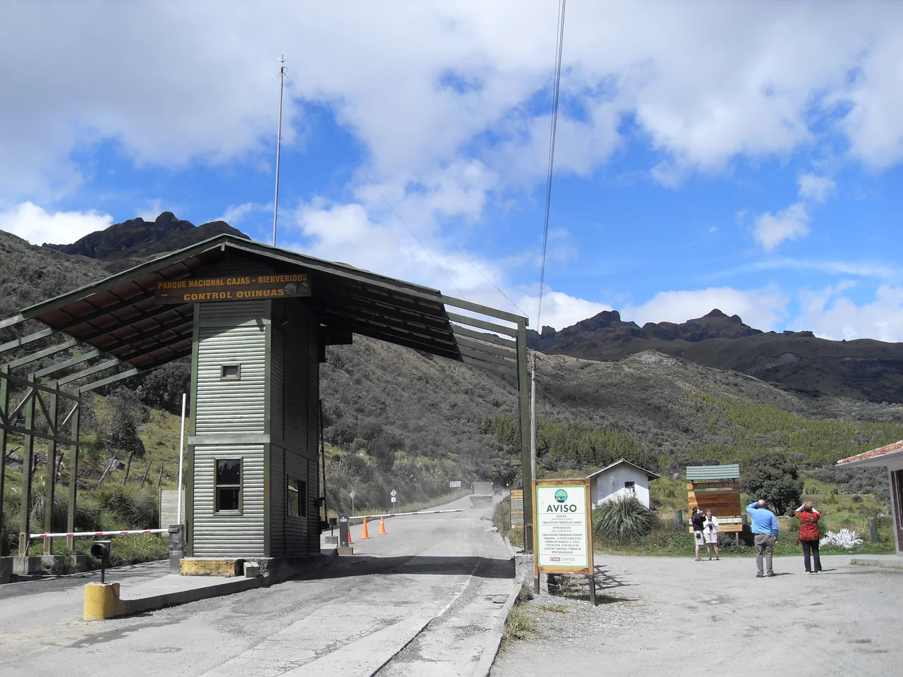
For one US dollar, a Transporte Occidental bus will take you from Cuenca to the edge of an alpine wilderness. The ride lasts thirty minutes, climbing highway 582 west into the Andes, past roadside shrines and thinning air, until the bus pulls into the eastern entrance of El Cajas National Park. You step off at 3,800 meters, hand your passport to a ranger at the front office, and sign in. Then you walk. This is the cheapest entry to a world-class hiking destination in South America. The park has 270 lakes. The lakes were carved by glaciers during the last ice age. Twenty-eight archaeological sites within the park confirm that people have lived here for at least a thousand years.
Route One in Three Miles
The shortest popular hiking loop in the park is called Route One. It runs approximately three miles, no technical climbing required, and takes most hikers between two and four hours depending on fitness and pace. Route One winds through several lagoons and into a genuinely strange-looking forest of paper trees - the local name for the queñua or polylepis, whose bark shreds in layers of reddish papery sheets and whose twisted, bonsai-like form has evolved specifically to survive at this altitude. The trail is not flat. It runs up and down, with lengthy uphill sections that feel significantly harder than their grade suggests because of the elevation. Most hikers underestimate what 3,500 to 4,400 meters of altitude does to exertion. Rangers at the entrance recommend that inexperienced hikers take a guide; getting lost in Cajas is possible, and weather turns fast. Several other routes exist, varying in length from short day-hikes to multi-day traverses, but Route One is the one most visitors do.
270 Lakes
The lakes are the reason the park looks the way it does. When glaciers receded from this valley at the end of the last ice age, they left behind 270 depressions now filled with cold, clear water. The largest is Laguna Luspa, which reaches nearly seventy meters deep. The park also holds the headwaters of four important rivers - the Tomebamba, Yanuncay, Balao, and Canar - and the continental divide runs through it, meaning that two of those rivers flow west to the Pacific and two flow east toward the Amazon basin. The headwaters that emerge here eventually supply the drinking water for the city of Cuenca, which is part of why Ecuador designated the park a Ramsar wetland of international importance in 2002. Cuenca's famously drinkable tap water begins as rain falling on this paramo.
What Lives Here
The vegetation is paramo - high-altitude grassland with characteristic Andean adaptations to cold, wet, windy conditions. Straw grass is the dominant species, but 19 plants are endemic to Cajas - found nowhere else on Earth. Above 3,300 meters, the paper trees take over. An endemic plant called the flower of the Andes grows in scattered patches. 157 bird species have been cataloged in the park, including the magnificent Andean condor, soaring on thermals between the peaks. The giant hummingbird - Patagona gigas, the largest hummingbird in the world - lives here, feeding on agave flowers with a bill long enough to reach the nectar. Over forty mammal species inhabit the park. Llamas are the most visible, often grazing near the trails. Smaller mammals include weasels, skunks, foxes, opossums, coatis, pacas, rabbits, and porcupines. Puma range through the park too, though sightings are rare. Two endemic mammals, the Cajas water mouse and the Tate shrew opossum, exist only in this specific protected area.
The People Before the Park
Twenty-eight archaeological sites within the park document at least a thousand years of continuous human use. Some are definitely pre-Inca - Canari in origin, left by the agricultural and metallurgical culture that inhabited this part of Ecuador from around 500 AD. Some are Inca, built during the relatively brief period of Inca control between the 1470s and the Spanish arrival in the 1530s. A few date to post-conquest settlements of the colonial era, when livestock replaced indigenous communities on the high grasslands. The continental divide running through the park made it a natural transit zone - Canari and Inca roads threaded the high country between the coast and the highlands, and Paredones, a control point for trade between highlands and coast, stands within the park's boundaries. During colonial times, livestock grazed the grasses of the high fields, a use that continued in pockets until the park was established in November 1996.
The Altitude Problem
Cajas is not kind to unprepared visitors. Hikers arriving directly from sea level often feel the altitude within the first hour: headaches, nausea, shortness of breath, fatigue that seems disproportionate to effort. The park's lowest trails sit at 3,500 meters, and the highest point, Cerro Arquitectos, reaches 4,450 meters. Acclimatizing in Cuenca for a day or two before hiking helps - the city's 2,500 meters is a reasonable staging altitude. Warm layers matter year-round; the park is significantly colder than Cuenca and weather can swing from sunny to freezing rain in an hour. Coca tea, available at most hotels and restaurants in Cuenca, helps some visitors. Rangers recommend a steady slow pace with frequent rests rather than the quick stops some lowland hikers prefer. Nobody should feel embarrassed about turning around. The paramo is not going anywhere.
Getting There
The park is about thirty kilometers west of Cuenca via highway 582. By car the drive takes around thirty minutes through scenic mountain terrain. A taxi from Cuenca costs between US$10 and US$15 for the one-way trip and can be arranged for a return pickup. The cheapest option is the Transporte Occidental bus from Cuenca's Terminal Terrestre, which runs frequently throughout the day for about one US dollar each way. The bus drops visitors at the eastern entrance ranger station. Coming back can involve some waiting, since buses returning to Cuenca pass the park gate on an irregular schedule. Park admission is free, but visitors must check in at the front office and leave their passports on file while they hike. The ranger station has restrooms and a small cafeteria. Hiking, camping, and trout fishing are all permitted in designated areas, and the park is an established stop on most tourist circuits through southern Ecuador.
From the Air
El Cajas National Park centered at 2.85 S, 79.22 W, 30 km west of Cuenca. Elevation range 3,100 to 4,450 meters. Nearest airport Cuenca Mariscal Lamar International (SECU) at 2,530 meters - flights to Cuenca routinely cross park airspace on approach from Guayaquil. 270 alpine lakes visible from altitude as distinctive mirrored scatter across paramo landscape. Continental divide runs through the park. Weather changes rapidly at elevation; morning flights preferred; afternoon thunderstorm buildup over the Andes common January-May.
Nearby Stories
- El Guabo Canton 8.7 km away
- Machala 45 km away
- Ingapirca 46 km away
- Clock Tower of Guayaquil 50 km away
- Saraguro People 51 km away
- Cueva de los Tayos 63 km away
- Sangay National Park 101 km away
- Borja, Peru 197 km away