
Euonymeia
One of the men who prosecuted Socrates came from here. Anytus — Strategos, a respected general of Athens — was a son of the Deme of Euonymos, the ancient community that occupied these limestone hills south of the city. He brought charges in 399 BCE and saw them through to the fatal verdict. Walk through the neighborhood today, known colloquially as Ano Kalamaki but carrying the ancient name Euonymeia in its DNA, and this is the kind of history that lies underfoot. Not monument history. Not the history of temples and battles, though those are here too. The quiet, embedded history of a place that has been continuously inhabited for more than five thousand years.
The Name That Means Well-Named
The name Euonymeia has been documented since at least the sixth century CE, when the scholar Stephanus of Byzantium recorded it in his *Ethnica*, the earliest authoritative gazetteer of Mediterranean place names. Stephanus traced the name to Euonymus of Greek mythology — a son of Gaia, the earth herself, with either the sky-god Uranus or the river-god Cephissus. The name's Greek roots tell their own story: *eû* meaning 'good' or 'well,' and *onoma* meaning 'name.' A place of good repute. The medieval name Trachones, by contrast, came from the land itself — *trachoni*, meaning 'rock,' from the ancient adjective *trachys*, 'coarse.' The limestone hills gave the village its second identity, harder and more geological than the mythological first. Today the neighborhood goes by Ano Kalamaki, 'upper Kalamaki,' a designation that arose only in 1968 when it was administratively merged with the coastal settlement of Kalamaki to the west. Three names, five thousand years of occupation.
Before Athens Was Athens
Settlement here predates the city it would eventually border by millennia. The hills of Euonymeia, together with the nearby coastal promontory of Agios Kosmas, are among the most important Neolithic and Bronze Age sites in the Athens area. Obsidian tools and ceramics found at both locations were traced to the island of Melos, indicating that these earliest communities had trading connections with the Cyclades at least three thousand years before the classical era. A Mycenaean chamber tomb has been identified on the Geroulanou Estate; in 2006, construction of the Alimos Metro station 300 meters to the south uncovered a large Mycenaean workshop complex with installations for ceramic production, including a kiln and potter's wheel. The complex also included hydraulic installations — wells and water conduits — used to process flax into textiles and to produce the sails and ropes that Mycenaean ships required. It is one of the largest such complexes yet found, located five kilometers south of the Mycenaean palace on the Acropolis of Athens.
Pottery That Crossed the Atlantic
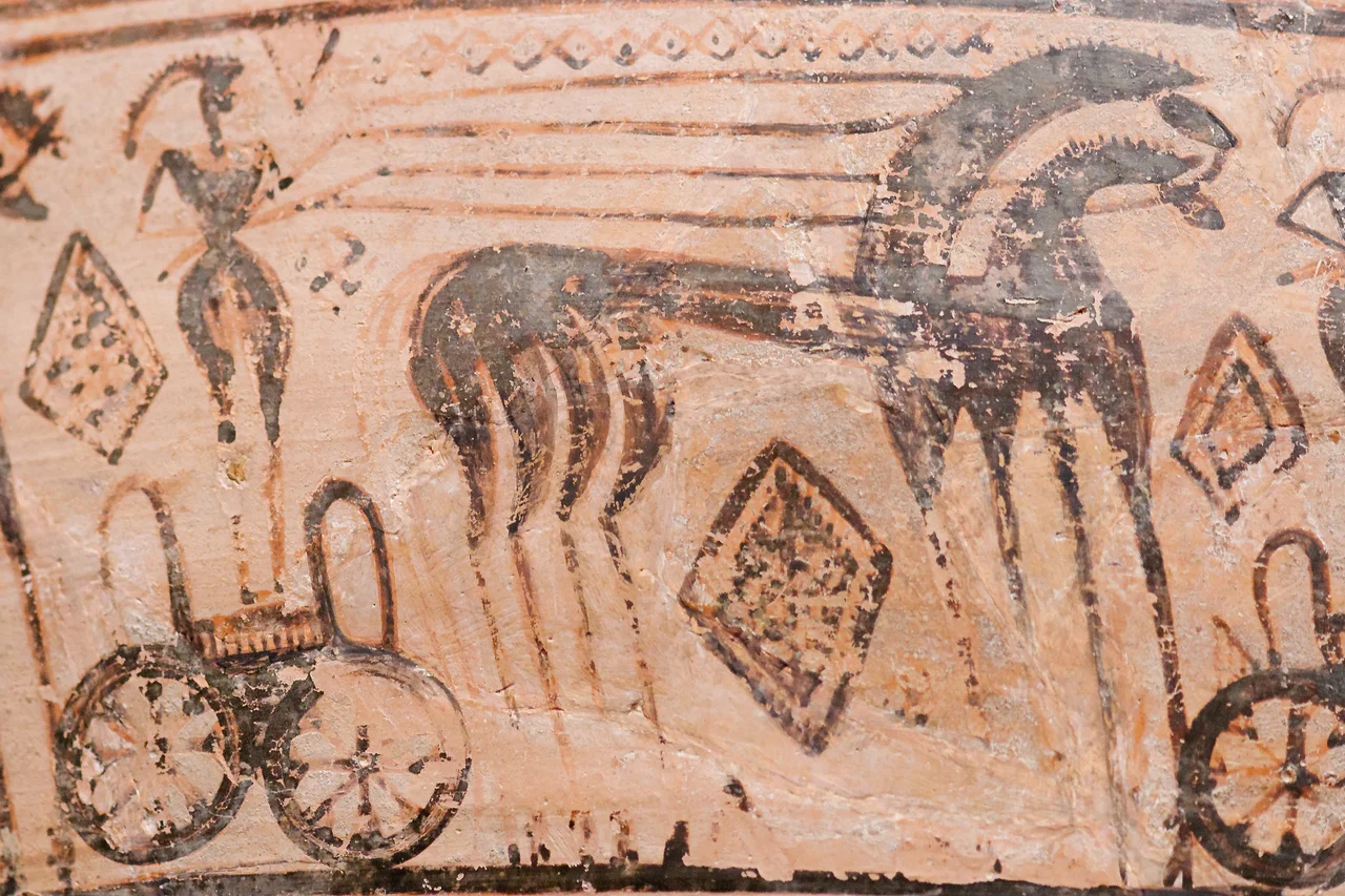
During the Geometric period of the Hellenic Dark Ages — roughly the tenth through eighth centuries BCE — the Trachones workshop produced ceramic vessels of remarkable quality. Ceremonial kraters from the workshop, used in burial tombs throughout Geometric Greece, are considered among the finest examples of Athenian Geometric pottery known. In 1914, the Metropolitan Museum of Art in New York City acquired two of these kraters; they remain on permanent display in the museum's collection of Greek and Roman Art. Euonymeia also practiced cremation during this period, a burial rite unusual for the Athens region. Neighboring demes favored inhumation. The reasons are unknown, but the peculiarity is documented in the archaeological record — another small divergence from convention in a place that has always had its own way of doing things.
A Theatre Unlike Any Other in Greece
The classical Deme of Euonymos came to light in 1975, when construction work uncovered a theatre. An inscription to the god Dionysus identified it as the Euonymos Theatre, previously known only from written references as one of the deme theatres of Athens. The building had been constructed in the mid fifth century BCE — making it one of the earliest deme theatres known — from Hymettian marble quarried in the nearby mountain. It held an estimated two thousand to three thousand spectators. And it was architecturally singular: its orchestra, the circular or semicircular performance space that defines ancient Greek theatres, was rectangular. No other ancient theatre found in Greece shares this feature. The Euonymos Theatre was destroyed during the Chremonidean War of the 260s BCE and never rebuilt. Two headless statues of Dionysus were found among its ruins.
Crusaders, Sultans, and One Stubborn Church
Euonymeia's later history is a compressed version of Greece's: Byzantine decline, Frankish conquest, Ottoman rule. During the medieval period the settlement became the village of Trachones, its ancient name fading. When the Fourth Crusade established the Duchy of Athens in the thirteenth century under the Frankish lord Othon de la Roche, the local community built an Orthodox church — the Presentation of Mary of Trachones — in deliberate defiance of the Roman Catholic allegiance the Frankish rulers demanded. That church still stands and operates within the Geroulanou Estate, one of the oldest continuously active churches in Athens. After Ottoman conquest, the area became a Chiflik, a feudal estate, and the local people became koligoi — mandatory land peasants bound to the estate. The church remained the center of civic life through all of it. Some things outlast their conquerors.
From the Air
Euonymeia occupies the limestone hills of the Alimos neighborhood at 37.923°N, 23.741°E, in the southern Athens urban area between Mount Hymettus to the east and the Saronic Gulf coast to the west. From the air, the neighborhood is part of the continuous dense fabric of south Athens, with Pan's Hill (Lofos Pani) providing a modest topographic reference point amid the urban grid. The Trachones stream, now largely underground, traces a path from the slopes of Hymettus westward through the neighborhood to Alimos beach. Athens International Eleftherios Venizelos (LGAV) lies approximately 18 kilometers to the east; aircraft on approach from the west often pass over or near this area at low altitude. A viewing altitude of 2,000 feet on a clear day makes the profile of Mount Hymettus — honey-brown in summer, violet at dusk — a dominant presence to the east, with the Saronic Gulf and the island of Aegina visible to the south.
Nearby Stories
- Parnitha 3.4 km away
- Kea (island) 7.3 km away
- Sanctuary of Apollo Maleatas 11 km away
- Sousaki Volcano 12 km away
- Battle of Leuctra 14 km away
- Great Sand Beach 18 km away
- Agios Georgios (island) 23 km away
- Skyros 84 km away