
Kea (island)
Every summer, the ancient inhabitants of Keos watched the sky. They waited for Sirius — the Dog Star, brightest in the firmament — to reappear after its weeks of absence below the horizon. If it rose clear and sharp, the year would bring good fortune. If it rose misty, pestilence might follow. They sacrificed to the star and to Zeus to coax cooling winds. Their 3rd-century BC coins showed dogs and stars with radiating rays. The ritual is gone, but the impulse it expressed — this small island's acute attention to the sky and sea and the forces beyond human control — seems fitting for a place that has attracted myth, poetry, and catastrophe in roughly equal measure across six thousand years.
Closest Cyclad
Kea sits at the northwestern edge of the Cyclades, only about 20 kilometers from Cape Sounio at the tip of Attica. The ferry from Lavrio takes roughly an hour. Geographically it belongs to the island chain; emotionally it has always been halfway between Athens and the deeper Aegean, accessible enough for weekend sailors but distinct enough to maintain its own identity.
The island measures 19 kilometers north to south and 9 kilometers east to west, covering 131 square kilometers. Its terrain is hilly, its climate arid, and its highest point reaches 560 meters. The capital, Ioulis, sits well inland at altitude — the typical defensive posture of Cycladic settlements built to avoid the sight lines of pirates. Korissia serves as the main port; Vourkari, a fishing village on an inlet nearby, draws yachts. After decades of depopulation, Kea has been gradually rediscovered by Athenians as a reachable escape, with the population standing at 2,568 in 2019.
Four Cities on One Island
In the Archaic period Kea was divided among four independent city-states — poleis — each controlling its own territory: Ioulis, Karthaia, Poieessa, and Koressos. Four governments, four sets of temples, four harbors, on an island not much larger than Manhattan. The competition and cooperation between them shaped the island's character across centuries.
People have lived on Kea since at least 4600 BC. The Neolithic settlement at Kephala, on a rocky promontory in the island's north, is the only significant open settlement of its period in the Cyclades — meaning it had free-standing structures rather than defensive walls. Its inhabitants farmed cereals, kept livestock, fished, and made tools from obsidian brought from Melos. They also worked copper, placing Kephala among the earliest metalworking sites in the Aegean. The copper they used may have come from the mines of Lavrion, just across the water in Attica. The Bronze Age settlement at Ayia Irini reached its height between 1600 and 1400 BC, in the Late Minoan and Early Mycenaean eras.
The classical period gave the island two lyric poets — Simonides (c. 556–468 BC) and his nephew Bacchylides — as well as the Sophist philosopher Prodicus and the physician Erasistratus. That a small island produced this concentration of intellectual life in a single era says something about the culture that the four city-states sustained together.
The Lion of Kea
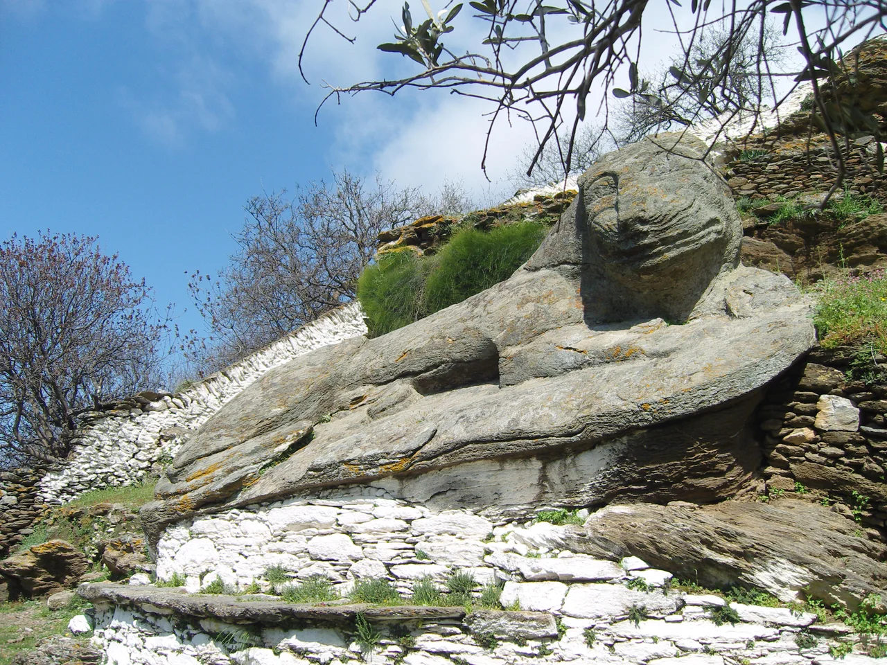
Near the town of Ioulis, carved from a single outcrop of local granite sometime before 600 BC, lies the Lion of Kea — also called the Lion of Ioulis, or simply the Liontas. It is one of the largest and best-preserved archaic stone sculptures in Greece, roughly ten meters long, cut directly from the living rock of the hillside. The lion reclines, its mouth open, its expression alert. It does not look defeated or decorative; it looks like it is waiting.
The legend attached to it explains the carving as a memorial. According to the story, Kea was once home to water nymphs whose beauty made the gods jealous. The gods sent a lion to devastate the island. The stone lion commemorates that threat, or perhaps depicts the creature itself, tamed and frozen in place. As a practical matter, lions did inhabit mainland Greece throughout the classical period — they were not mythological animals to the Greeks who carved this one. Whether the Kean lion marks a memory of real danger or a mythological episode, it has outlasted every other structure on the island by a considerable margin.
Ships on the Bottom
Kea has accumulated wrecks the way old ports accumulate history. The most famous is the HMHS Britannic, sister ship of the Titanic and the largest of the three Olympic-class ocean liners built by the White Star Line. Britannic sank in the Kea Channel on 21 November 1916 after hitting a mine during the First World War, killing thirty people. She now lies at a depth of about 122 meters, roughly 1.5 nautical miles offshore — the largest ship sunk in World War I, accessible to technical divers but not recreational ones.
Two other wrecks sit in shallower water. The paddle-wheel steamship Patris went down on 24 February 1868 after hitting a reef at Koundouros Bay. She carried around 120 passengers; no casualties were reported because of her proximity to shore. She lies at 28 meters, well within recreational diving range. The SS Burdigala, a 180-meter French ocean liner built in Germany, sank 14 November 1916 after striking a mine in the Kea Channel off the island's northwest coast. She rests at approximately 70–76 meters. This concentration of wrecks within a small geographic area makes Kea one of the more distinctive diving destinations in the Aegean, with water temperatures between 20 and 26 degrees Celsius and strong visibility.
A Long Continuity
Kea passed through Byzantine rule, Venetian occupation (from 1204, following the Fourth Crusade), Byzantine recapture (under Licario in 1278), another period of Venetian control (after 1302), Ottoman conquest in 1537, and finally incorporation into modern Greece following the War of Independence in 1821. A plague in 1823 killed between 1,600 and 2,000 Keans — a significant fraction of a population estimated at over 7,000 in that year. The 19th century saw slow demographic decline that continued through most of the 20th.
What persisted through all of it was the island's basic character: green and hilly by Cycladic standards, oriented toward the sea but anchored inland, close enough to Athens to feel connected but far enough to feel apart. Mary Renault set much of her novel The Praise Singer on Kea, using the island and its poets as the frame for a portrait of archaic Greek life. The choice was not arbitrary. Simonides, born here around 556 BC, spent his career celebrating athletes and the war dead in verse that survived him by two and a half millennia. The island that produced him — small, watchful, attentive to the sky — seems like the right place for a poet.
From the Air
Kea (Tzia) lies at approximately 37.61°N, 24.34°E in the northwestern Cyclades. From the air, the island is easily identified by its elongated shape — roughly 19 km north to south — set off by the deep blue of the Aegean. The Kea Channel separates it from the Attica coast to the northwest. Cape Sounio and the Temple of Poseidon are visible on the mainland roughly 20 km to the north. At 3,000–5,000 feet, the island's terraced hillsides, the bay at Korissia (main port, northwest coast), and the inland capital of Ioulis are all distinguishable. The nearest major airport is Athens International (LGAV), approximately 70 km to the northwest. The wreck of the HMHS Britannic lies 1.5 nautical miles offshore in the Kea Channel at the island's northern end.
Nearby Stories
- Anagyrous 8.9 km away
- Serifos 14 km away
- Greek Cruiser Elli (1912) 17 km away
- Hellenic Centre for Marine Research 23 km away
- Greek Islands 23 km away
- MS Express Samina 24 km away
- Karystos 25 km away
- Spetses 68 km away