
Fallmore
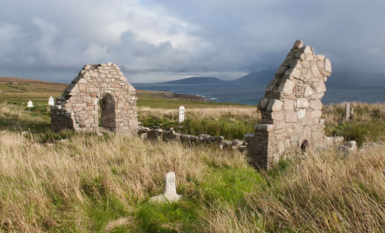
Three hundred yards from the sea, on a low knoll above a sandy beach at the southern tip of the Mullet Peninsula, stands a small ruined church of polygonal masonry. It was built in the eleventh or twelfth century on the site of a much older religious settlement said to have been founded in the late sixth century by an anchoress named Dairbhile. Some of the foundation stones excavated here may date back to her lifetime. The church bears her name still - Saint Dairbhile's, or Teampall Deirbhile in Irish - and the townland of Fallmore that surrounds it has been Irish-speaking continuously for as long as anyone has been keeping records. Population at the 2011 census: 75 people, spread across 704 acres of dune, machair and bog.
Saint Dairbhile
Dairbhile - sometimes spelled Darbiled or Deirbhile - is one of the more obscure of Ireland's early Christian saints, but on the Mullet Peninsula she is the central religious figure. Tradition holds that she lived as an anchoress here between roughly 575 and 600 AD, in a beehive cell of stone on the windswept point above the sea. The current church on the site dates from at least the 1100s, but it was built on the foundations of much older religious structures. Local pilgrims still visit Dairbhile's holy well a short walk from the church. The waters are reputed to cure eye ailments. Tradition also holds that anyone who passes three times through the window of the ruined church will be protected from drowning - a useful blessing on a peninsula where the Atlantic claims lives every winter.
The Rundale System
Long before the modern field system arrived in Erris, the people of Fallmore farmed by a method called Rundale - a form of communal land tenure in which the better land was periodically redistributed among the families of the townland, ensuring that no one family was permanently stuck with the poorest plots. An American researcher named Tom Yager spent years studying the surviving Rundale practices on the Mullet, and his work has helped historians understand exactly how the system worked. The community followed a common crop rotation, alternating between grain and potatoes; Patrick Knight, an engineer who planned and built nearby Belmullet for landlord William Carter, described a three-year rotation in his 1836 book on Erris. Yager thought the third field probably lay fallow, gathering strength. Much of Fallmore is still managed as unfenced commonage, and where the old practices have survived, the ecological condition of the land is measurably better than where the fields have been enclosed and grazed more intensively. The old ways turn out to have been good for the soil.
The Palmer Clearances of 1857
In 1857, a Church of England clergyman named William Palmer purchased the townlands of Termon and Fallmore. The Famine of 1845-1852 had ended only a few years earlier, the population was already shattered, and Palmer set about 'improving' his new estate. This meant ending the Rundale system in favour of fenced, individually-tenanted farms - 'striping' the land into long, narrow plots. It also meant evicting families whose tenancies no longer fit the new scheme. The Mullet Peninsula clearances of the 1850s are documented in a 1996 article in a journal of Irish economic history; they were not the largest in Ireland, but they were notable for the speed and method with which they were carried out by a man whose stated motives were religious and economic improvement. The people who were cleared went where they could - to America, to Scotland, to England, or to even more marginal land elsewhere on the peninsula. The shape of Fallmore today, with its scattered houses and unfenced commonage, is partly an inheritance of what Palmer did and partly the resilience of what he could not undo.
Where the Land Ends
Fallmore townland also includes the small village of Blacksod itself - the pier where ferries leave for the Inishkea Islands, the white square tower of Blacksod Lighthouse a kilometre away, the few houses clustered along the road. The geology underfoot is metamorphic schist with veins of gneiss, weathered by Atlantic wind into a landscape with almost no trees. Most of Fallmore is covered in fixed dunes and hilly machair - the rare lime-rich grassland that supports rare flora and the strikingly red-billed chough. The tallest point is Termon Hill at 103 metres, where the granite quarry that built Blacksod Lighthouse once cut its stone. Portions of the townland now form part of the Mullet/Blacksod Bay Special Area of Conservation, recognising the ecological importance of what 1,400 years of monks, farmers, evictions, and quietly stubborn families have preserved here. Saint Dairbhile would have known this exact view.
From the Air
54.10N, 10.09W. Fallmore lies at the southern tip of the Mullet Peninsula, recognizable from the air as the narrowing point of the long Mullet finger before it drops into the Atlantic. Blacksod Lighthouse stands prominently 1 km southwest at the entrance to Blacksod Bay; the Duvillaun Islands lie 2-3 km offshore to the south. Saint Dairbhile's Church appears as a small rectangular ruin on a low knoll above the eastern shore. Best viewed at 1,500-3,000 ft. Ireland West Airport Knock (EIKN) is approximately 90 km east-southeast. Expect strong Atlantic winds and rapidly changing visibility.
Nearby Stories
- Aughagower 3.4 km away
- Caher Island 8 km away
- Enaghbeg 10 km away
- Action of 7 May 1794 21 km away
- Lissadell House 59 km away
- RMS Carinthia (1925) 64 km away
- Glencolmcille 95 km away
- Inishtooskert 214 km away