
Farranfore–Valentia Harbour line
There was once a train you could catch in Dublin in the morning and step off at the edge of the Atlantic in the afternoon, two and a quarter hours from Farranfore to Valentia Harbour, the most westerly railway station in Europe. The line climbed and curved for 39.5 miles along the southern shore of Dingle Bay, single-track, broad gauge, and so tightly bent in places that for decades it could not accept eight-wheeled coaches at all. It opened in 1893 with a transatlantic dream behind it. It closed in 1960 because the people who used it could now afford cars. What remains is a viaduct, a couple of tunnels, the long curving scar of a trackbed, and the kind of memory that small communities polish.
The Transatlantic Dream That Didn't Happen
Long before the line was built, an ambitious engineer named Charles Blacker Vignoles, who had laid out the 1834 Dublin and Kingstown Railway (Ireland's first), proposed extending rails all the way to Valentia Harbour to make it a great transatlantic port. Steamships could embark passengers there at the western tip of Europe, the argument went, and gain a day on the crossing to America. The proposal was too big for its time. The Great Southern and Western Railway eventually picked up a more modest version of the plan, opened the 12.5-mile Farranfore-to-Killorglin section in January 1885, and pushed on with the 27-mile extension to Valentia, formally opening it on 12 September 1893. The transatlantic port never materialised. What did was a working branch line through some of the most spectacular coastline in Ireland, climbing through the mountains of County Kerry and crossing rivers and gorges to reach a quayside where a ferry could take you to Valentia Island.
Sharp Curves and Small Engines
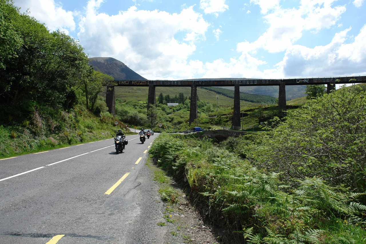
The engineering on the line was as inventive as the terrain demanded. From Killorglin the gradient ran up to 1 in 50, steep enough that maximum speeds dropped to 30 mph and sometimes less. The track climbed past Glenbeigh, kept the southern shore of Dingle Bay close on the right, and threaded the slopes of the Iveragh Peninsula on the left. Tunnels were cut where shoulders of rock could not be turned. The Laune Viaduct carried the line over the river just before Killorglin; further west, the Gleensk Viaduct strode across a steep glen on stone piers. Because the curves were so tight, the locomotives had to be light: a 14.5 long-ton axle load remained the limit even in 1948. The little Class 101/J15 engines, ubiquitous workhorses of the Irish railway, ran most of the trains, and several were based at Tralee. Six-wheeled passenger coaches stayed in service throughout because the bogie coaches did not fit the curves. After 1935 longer carriages were allowed past certain points, but only if their buffers met strict specifications.
Three Trains a Day, and Then One
When the line opened, three passenger services ran each way, and it served as the main transport system for the Iveragh Peninsula for seventy-five years. Fish came out, mail came in, schoolchildren and shopkeepers and farmers used the small stations at Glenbeigh, at Cahersiveen, at Caragh Lake. The terminus at Valentia Harbour had no turntable: locomotives ran their 2.5 miles back to Cahersiveen each night to be stabled. By 1954 service had thinned to a single daily passenger train each way, supplemented by two slower goods trains that carried some passengers as well. The C-Class diesels arrived in 1957, brand-new to Ireland, and worked the branch in its final years; CIE 2600-class railcars ran occasional excursions. The last train pulled out of Killorglin on 30 January 1960, and the line officially closed on 1 February.
What the Trackbed Holds
Most of the buildings are gone, taken down or absorbed into other uses, the way disused railway property always is. But the Laune Viaduct still stands in Killorglin, broad and useful-looking even without rails on it. Two tunnels still slice through hillsides on the line west of Glenbeigh. The Gleensk Viaduct still strides across its glen, a stone arcade carrying nothing now but the wind. There is talk, and has been for years, of converting the trackbed into a long-distance greenway, a walking and cycling route that would let people retrace the journey at a slower pace. Some sections have already been taken on for that. Stand on the Gleensk piers and look west: the bay opens up, the headlands fall away, and it is easy to understand why a Victorian engineer thought you might one day catch a steamship to Boston from a station at the end of this track.
From the Air
The Farranfore-Valentia line ran between 52.156 N, 9.535 W (Farranfore) and 51.927 N, 10.300 W (Valentia Harbour), curving south-west along Dingle Bay through Killorglin, Caragh Lake, Glenbeigh, and Cahersiveen. From the air the trackbed reads as a faint curving cutting and embankment along the southern shore, visible at low altitude where vegetation has not yet swallowed it. The Laune Viaduct in Killorglin and the Gleensk Viaduct in its steep glen are the standout structures. Nearest airport is Kerry (EIKY) at Farranfore itself; Shannon (EINN) lies about 90 km north. Best viewing altitude is 1,500 to 4,000 ft along the southern shore of Dingle Bay; expect rapidly changing visibility as Atlantic weather sweeps in.
Nearby Stories
- Inishtooskert 2.5 km away
- Staigue stone fort 5.6 km away
- Listowel 7.1 km away
- Castleisland 13 km away
- Ballyheigue Castle 13 km away
- Kealkill stone circle 15 km away
- RMS Carinthia (1925) 93 km away
- Sao Miguel 1951 km away