.jpg)
Fat Tong Chau
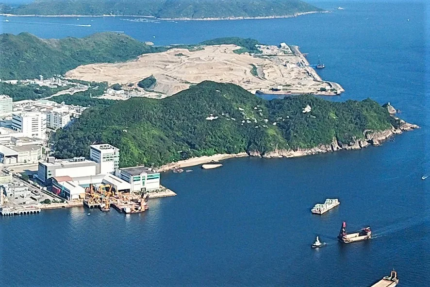
There used to be an island here. Fat Tong Chau — also known as Junk Island in English, and formerly as Fat Tau Chau or Fu Tau Chau — once rose from the southeastern waters of Junk Bay, a small landmass with a handful of villagers, some pigs and chickens, and a customs station that handled the taxation of opium. Land reclamation in the late twentieth century absorbed it into the surrounding peninsula. The island became a former island. Its coordinates now point to the edge of the Tseung Kwan O Industrial Estate, with TVB City's broadcasting towers a short distance to the east. But the ruins are still there, and so is the inscribed stone slab that explains what this place once was.
The Village at the Edge of Things
By the time official records began noting the place, Fat Tong Chau was already small. A population of 12 was recorded in 1911. Writer Austin Coates, who documented rural Hong Kong life in the mid-twentieth century, noted that the village had been founded around 1885 and held a population of 23 by 1955 — all of the surname Ip. Scholar James Hayes recorded 34 residents in 1957–1958. The villagers cut grass, raised sweet potatoes, kept pigs, ducks, and chickens. Their children attended school at Pan Long Wan on the mainland, where the Ip family had over generations intermarried with members of the Lau clan. To reach the market at Shau Kei Wan — the principal outlet for their agricultural production — they crossed the water by sampan. It was a life of carefully maintained routines, entirely dependent on the water that surrounded them on all sides, connected to the wider world by boats and by the ties of clan.
The Emperor's Customs Post
When archaeologists examined the ruins at Fat Tong Chau in 1962, they found a stone slab broken into four pieces. The inscription, translated, reads: 'By the Grace of the Emperor, tributes are accepted from and customs exchange with Annam, which is far away from China. Renovated by the Manager of the Customs Station.' Annam was a historical Chinese name for the Vietnamese kingdom — encompassing what is now Vietnam. The customs station at Fat Tau Chau had been established in 1868 by order of the Viceroy of Liangguang — one of three such posts, along with stations at Cheung Chau and Kap Shui Mun at Ma Wan — to collect likin, an internal transit tax, on the opium trade. Opium smuggling through Hong Kong's waters was intense in the latter half of the nineteenth century, and these coastal stations were the Qing dynasty's mechanism for extracting revenue from trade it could not otherwise control. The station at Fat Tau Chau operated until 1899, when the New Territories lease to Britain rendered it redundant.
The Island That Became Land
Hong Kong has created hundreds of hectares of new land by reclaiming it from the sea — a process that reshaped not just coastlines but the identity of places. Fat Tong Chau lost its islandhood to this process, absorbed into the landmass of Tseung Kwan O and the Clear Water Bay Peninsula during the development of Junk Bay's new town. Before reclamation, the island had formed the northern boundary of Tathong Channel. Afterward, the channel itself changed shape, and the island became a topographic memory. Today the former island sits inland of the coastline, surrounded not by water but by industrial estate and landfill — the South East New Territories Landfill occupies the area to the south. Three Sites of Archaeological Interest mark what remains: the Fat Tau Chau SAI, the Fat Tau Chau House Ruin, and a Qing dynasty gravestone. Archaeological finds from the site are on display at the Hong Kong Museum of History.
What Persists
There is something quietly striking about the trajectory of Fat Tong Chau. An island with fewer than forty residents, a subsistence economy, and a customs post for taxing the nineteenth century's most traded narcotic — it seems, on paper, like a footnote. But the customs station inscription speaks to the scale of the world it was embedded in: trade routes reaching from southern China to Vietnam and beyond, imperial bureaucracy trying to tax what it could not stop, smugglers working the same waters that the Ip clan crossed by sampan to reach the market. The ruins of all of that now sit inside a modern industrial zone, where TVB City produces television dramas watched across Asia. The island is gone, but its stone slab survived, and the Hong Kong Museum of History thought it worth keeping.
From the Air
Fat Tong Chau's former location lies at approximately 22.280°N, 114.268°E in the Tseung Kwan O area of Sai Kung District, Hong Kong. Approaching from VHHH (Hong Kong International Airport, roughly 32 km to the west-northwest), fly east to Junk Bay. At 1,500–2,500 feet, the industrial estate and TVB City complex are visible on the reclaimed land that now covers the former island's position. Port Shelter and the Clear Water Bay Peninsula extend to the south. The Tseung Kwan O residential towers are visible to the north and east, built on the same reclaimed land that absorbed the island.
Nearby Stories
- Shek Pik 1.7 km away
- Tung Ping Chau 4.8 km away
- Hong Kong 12 14 km away
- Wanshan Archipelago Campaign 16 km away
- Pearl River Delta 18 km away
- Battle of Penghu 478 km away
- Penghu Air Raids 487 km away
- Cape Maobitou 596 km away