The Forgotten Citadel of Makassar
Twenty-five warriors stood in a gap blasted through 3.5-meter-thick brick walls, wooden stakes in hand, trying to seal a hole that explosives had torn 27.5 meters wide. It was June 14, 1669, and the fortress they were defending -- Somba Opu, the commercial capital of the Gowa Sultanate -- was enduring what the Dutch East India Company would later call one of the most difficult campaigns it had ever undertaken in the East. The fortress would fall. But the story of how it rose, what it meant, and how it vanished beneath the delta mud of the Jeneberang River is one of the most remarkable and least-told chapters in Southeast Asian history.
A Sultanate's Beating Heart
Somba Opu grew from the oldest settled ground in Makassar, where the Kale Gowa stood on elevated terrain along the north bank of the Jeneberang River. Within its two-kilometer perimeter of walls lay sacred coronation stones where new rulers -- the karaeng -- took their oaths of office, a sacred spring, and the tombs of kings. Chinese and Sawankhalok porcelain scattered through the site hint at trade networks reaching deep into the 16th century. When the karaeng Tunipalangga permitted Malay merchants to establish a trading port at Mangallekana in the 1550s, commerce exploded. The port needed a capital nearby, so Tunipalangga ordered a new fortress built a kilometer from the Jeneberang's mouth. Somba Opu was born -- not as a military garrison, but as the nerve center of a trading empire that would draw Portuguese, Indian, and European merchants to its gates.
Wooden Palaces and Northern Markets
Under the long dual rule of Sultan Alauddin and Karaeng Matoaya from 1590 to 1637, Somba Opu became a city within walls. Dutch maps from the 1630s show the layout: two enormous wooden palaces raised on thick pillars dominated the southwest corner, flanked by storehouses and a mosque. The royal complex formed the fortress's core, while detached houses for kings and nobles filled the northern and eastern quarters. Outside the walls, two major markets hummed with activity to the north and south, and commoners' houses clustered beyond. Along the north coast, the Portuguese and Indians maintained their quarters alongside European trading factories. The original Gowa, meanwhile, retreated into ceremony -- a place for inaugurations and burials while Somba Opu handled the business of empire. By the early 17th century, anticipating Dutch aggression, the sultanate fortified the entire coastline. Additional brick forts rose at Tallo, Panakukkang, and Ujung Pandang -- the last of which would eventually become Fort Rotterdam, the one fort most visitors to Makassar know today.
The Siege That Ended an Empire
The Bungaya Treaty of 1667 was supposed to end hostilities between the Gowa Sultanate and the VOC. It did not. By 1669, Admiral Cornelis Speelman had assembled a coalition that revealed the fractures of the archipelago: 2,000 Bugis soldiers -- the Gowa's bitter rivals -- joined by fighters from Ternate, Tidore, Bacan, Butung, and even Pampanga in the northern Philippines. The Dutch themselves contributed just 83 soldiers and 11 sailors. The assault began with a tunnel packed with explosives, and the blast tore open Somba Opu's western wall. Six days of continuous rain followed. On June 22, the Bugis prince Arung Palakka led his forces through the breach in a ferocious charge. Despite the downpour, they set fires that drove Makassarese defenders from the bastions. Sultan Hasanuddin refused to abandon the citadel until flames, fanned by a northwesterly wind, left him no choice. The last holdout was Karaeng Karunrung, who remained in the palace surrounded by his kris-wielding followers until the end.
Stripped, Drowned, Forgotten
Victory was thorough and methodical. Eight thousand Bugis soldiers swept through the fallen fortress, seizing porcelain and copperwork before Speelman or Arung Palakka could reach the sultan's residence. The Dutch ensured Somba Opu would never rise again, throwing 33 large cannons, 145 small guns, 60 muskets, and over 8,000 bullets from the ramparts. The fortress walls themselves were dismantled -- their bricks carted off for Dutch buildings and local wells. Then the Jeneberang River did what no army could have planned. Over the following centuries, the delta shifted and grew, burying what remained of Somba Opu beneath layers of sediment. The fortress that had anchored a maritime empire became inaccessible from both land and sea, entombed in the alluvial plain of a river that no longer ran where it once had.
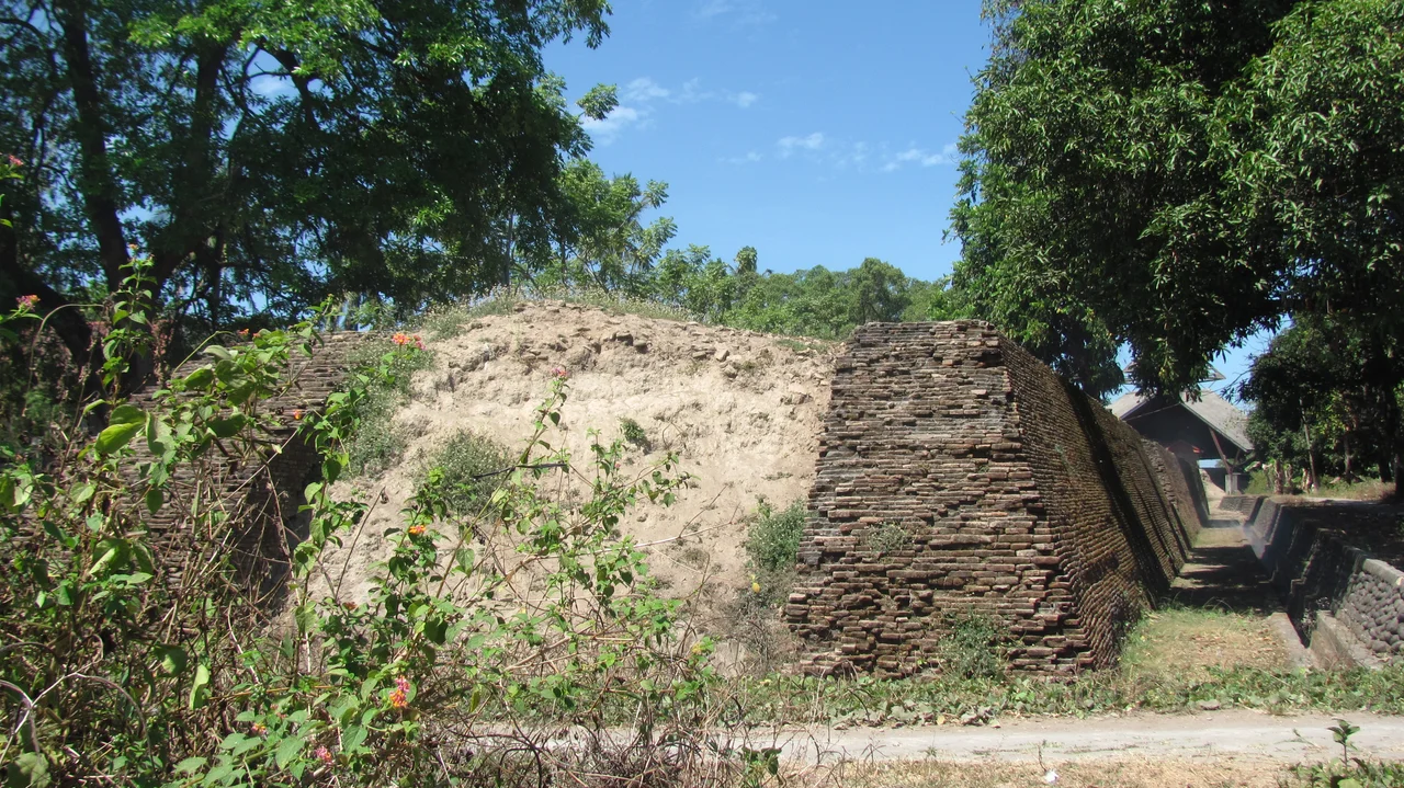
Unearthed and Overlooked
Somba Opu was rediscovered in the 1980s, marooned on an island formed between two mouths of the modern Jeneberang. Archaeologists found the southern section of the western wall -- 150 meters of red brick, 3.5 meters thick -- still standing, partly preserved because a holy tomb on the southwest bastion had discouraged scavengers. That bastion, now a mound 6.5 meters high, carries two names: Maccini Sombala, meaning "the sighting of sails," and Tompo Bataya, "the highest brick-formation." A 9-meter cannon was excavated along with artifacts now housed in a nearby museum. The fort was partly reconstructed in 1990, and an amusement park has since appeared at the eastern end of the site -- a development that worries preservationists. It remains, as one historian noted, strange that so little attention has been paid to the strongest fort ever built by Indonesians, and the scene of one of the fiercest battles they ever fought.
From the Air
Located at 5.19S, 119.40E on the Jeneberang River delta in southern Makassar, South Sulawesi. The fort ruins sit on a river island visible at low altitude. Sultan Hasanuddin International Airport (WAAA) is approximately 15 km to the east-northeast. Fort Rotterdam (WAAA approach path) lies about 7 km to the north along the coast. Best viewed at 2,000-3,000 feet when following the Jeneberang River from its mouth inland. The Makassar Strait stretches to the west.
Nearby Stories
- The Forest People Who Vanished 18 km away
- The Morning After the Strongman 24 km away
- Four Sails in the Selayar Strait 40 km away
- The Oldest Paintings on Earth 43 km away
- The Bird Letters of Sulawesi 57 km away
- Two Minutes of Distraction 157 km away
- The Five Minutes That Swallowed the Teratai Prima 193 km away
- Isuzu: The Cruiser That Refused to Sink 254 km away