Franca
The bandeirantes who cut the Caminho de Goiás in the 18th century needed a place to stop before the long climb toward the gold country, and the high sandy plateau where travelers found catfish in a cool stream was as good as any. They called it Pouso dos Bagres, the catfish camp. Today the catfish are gone, but the rest stop grew into Franca, a city of 352,537 people sitting at 1,040 meters above sea level in the far northeast of São Paulo state. Walk into a leather-goods shop anywhere in Brazil and check the label, and there is a better than fair chance it says this place.
The Catfish Camp on the Gold Road
In 1819, the French naturalist Auguste de Saint-Hilaire rode into the village and wrote what he saw. About fifty houses. A wide, rounded tongue of land, bathed on each side by small streams. Pastures running in every direction and the ground marked out for buildings not yet built. Saint-Hilaire could already see it coming. The parish had been founded in 1805 under the administrative shadow of Mogi Mirim, but by the time he arrived, Franca was close enough to emancipation that the sites for a proper town were already staked. In 1824, Emperor Pedro I gave the place its own boundaries and its full name: Vila Franca do Imperador. The city charter followed on April 24, 1856. The emperor's village had outgrown its stopover origins.
How Italians Turned Leather Into a Capital
Railroads reached the plateau around 1890 with the Estrada de Ferro Mogiana, and coffee followed the rails. So did Italian immigrants, many thousands of them, drawn by labor contracts on the coffee fazendas and by the promise that the Alta Mogiana soil would reward patience. The coffee paid the bills, but the sons and grandsons of the newcomers wanted something the ground could not grow. In the late 1920s, the first shoe factory opened. Others followed. By the late twentieth century the descendants of cobblers from Naples and Bari had made Franca what it calls itself today, the Capital Nacional do Calçado. The metal is Italian, the design studios train a new generation, and the thousands of medium and large firms that ring the city make boots, dress shoes, and athletic leather bound for shops across Brazil and beyond. A diamond-cutting industry grew alongside the shoe trade, another craft that travels well in small packages.
A City That Also Grew a Sport
Franca claims a second national title few cities can rival. It is the Capital Nacional do Basquete. The Ginasio Pedrocao fills for home games of the Franca Basquete team, and the coaches and players who came out of the town fill rosters across the country. Helio Rubens Garcia coached generations. Adrianinha and Guerrinha wore national colors. The footballers hold their own too: Estevao Willian, Silvinho, Marquinhos. Music comes from here as well, in the quiet guitar of Diego Figueiredo, and actress Regina Duarte grew up on these streets before becoming one of the most recognizable faces in Brazilian television. For a city the size of Franca, the density of talent is startling. The shoe workers built a municipal pride that had to spill somewhere, and it spilled into gymnasiums and stadiums.
The Plateau's Price and Privilege
At 1,040 meters, Franca is the fifth-highest municipality in all of São Paulo state. Elevation means cooler nights, drier winters, and the tropical savanna climate that coffee loves. It also means storms. The city is one of the rainiest in the state, and the Rio Canoas basin carries summer downpours through the town in short violent bursts. The sandstones of Bauru and Botucatu lie beneath the grass, and forests cling only to the steepest slopes, leaving most of the plateau open to pasture and cultivation. The highest temperature ever recorded here was 37.8 degrees Celsius on October 15, 2014. The lowest, 0 degrees, came on July 5, 1953, a cold morning that locals still talk about. The climate shaped the coffee, the coffee shaped the railway, and the railway shaped the city that grew up between.
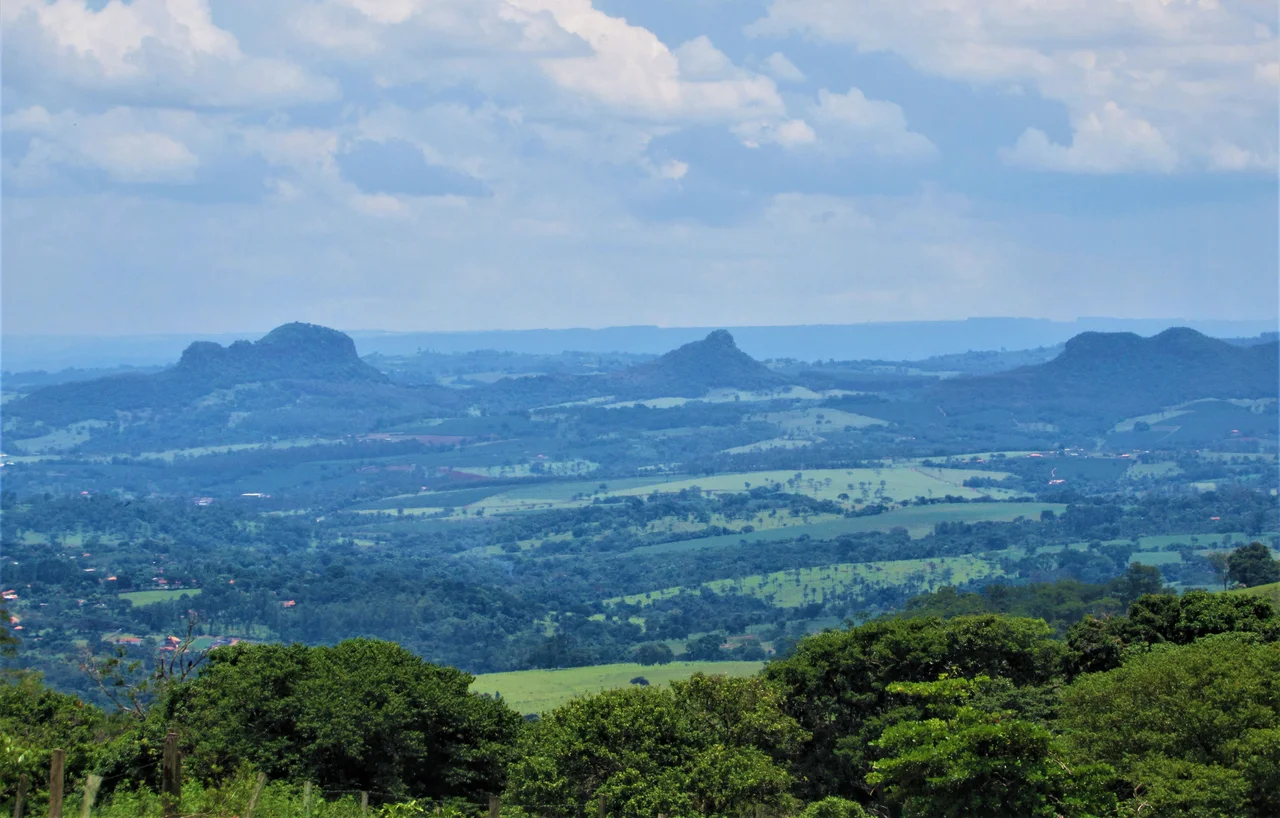
Passing Over the Shoe Country
From cruising altitude, the brown-and-green quilt of the Alta Mogiana plateau is unmistakable: coffee rows running in long combed lines, cattle pasture between them, and the dense urban grid of Franca rising up where the sandstones catch the afternoon light. The city sits on a wide, rounded tongue of high land with deep valleys falling away on each side, exactly as Saint-Hilaire described it two centuries ago. The Serra da Canastra looms to the north in Minas Gerais, its long ridge visible on clear days.
From the Air
Coordinates: 20.54 degrees south, 47.40 degrees west. Recommended viewing altitude 3,500 to 6,000 feet above the plateau (surface elevation 1,040 meters / 3,412 feet). The nearest field is Tenente Lund Presotto Airport (FRC / SBFC) on the northwest edge of town, with Ribeirao Preto Airport (RAO / SBRP) 88 km to the southwest. The high plateau produces afternoon convective buildups in summer, and Franca is one of the rainiest cities in Sao Paulo state.
Nearby Stories
- Southeast Brazil 23 km away
- Uberaba 53 km away
- Guaxupe 63 km away
- Ribeirão Preto 73 km away
- Capitólio 75 km away
- Titanochampsa 96 km away
- Olímpia 118 km away
- Patrocínio 145 km away