Olímpia
The newspapers call it the Brazilian Orlando. That is a considerable claim for a town of 55,130 people in the interior of São Paulo state, but Thermas dos Laranjais, the water park that dominates the local economy, has the numbers to back it up. In 2019 the park drew 1.8 million visitors, placing it repeatedly among the Themed Entertainment Association's most-visited water parks in the world. Olímpia has spent the last three decades rebuilding itself from a coffee and cattle town into a tourism economy, and in 2014 the São Paulo legislature officially designated it a touristic municipality. The waterslides were the wedge. The rest followed.
Before the Waterslides
Archaeological evidence pushes the area's history back a thousand years before European arrival. In the early 1990s, construction workers found four funerary urns containing bones, bead necklaces, and pots. Researchers later linked them to the Tupi and the Macro-Ge peoples, both indigenous groups whose reach extended across this region. Nineteenth-century settlers came for different reasons. As Brazil's gold mines exhausted and the country shifted into a coffee economy under the Empire, farmers moved into unexplored land to establish plantations and cattle ranches. A farmer named Antonio Joaquim dos Santos claimed land in the 19th century and called it Fazenda Olhos d'Agua, or Water Holes Farm, for the springs dotting the landscape. The town that grew from his farm kept the agricultural rhythm for a century.
The English Surveyors
In 1903, as the settlement grew beyond what a loose association of farms could manage, local landowners made an unusual decision. They hired two English immigrants, Robert John Reid and William Leatherbarrow, to subdivide the land and formally lay out the town. The British surveyors drew the streets. The newly platted town became a district of Barretos on December 18, 1906, and the residents named it Vila Olímpia after Maria Olímpia Rodrigues Vieira, daughter of one of the founders. Today several buildings from that founding era still stand as historical landmarks, including the old railway station and the first hospital, Beneficencia Portuguesa. The railway station in particular anchored the economy during the coffee century, moving beans out to the port cities and goods in from São Paulo.
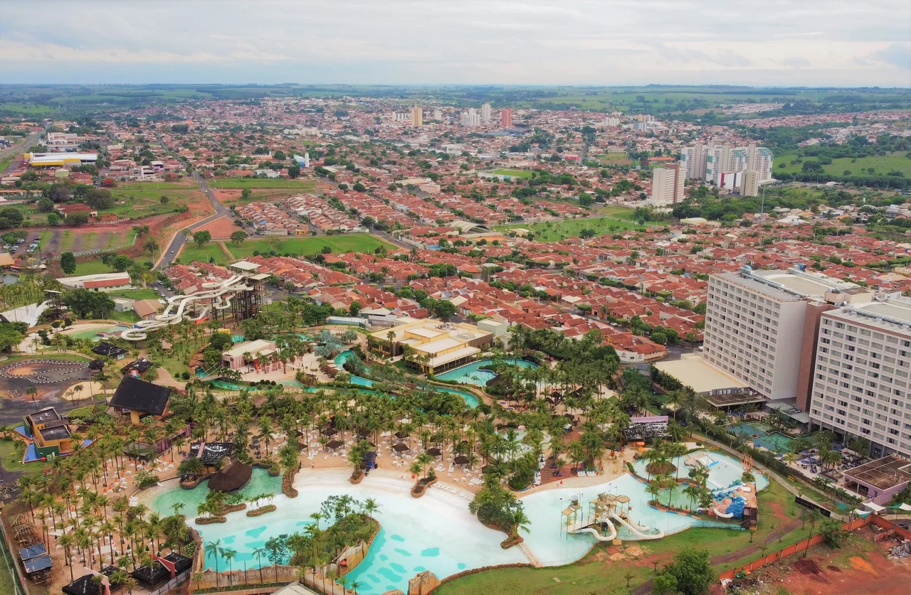
Thermas dos Laranjais
The park opened in 1987. It now covers 300,000 square meters and offers more than fifty-five attractions, including what the park describes as the largest complex of waterslides in Brazil. Surfing facilities, pools, and themed rivers share the grounds with family-oriented offerings. The Themed Entertainment Association ranked it repeatedly among the world's most-visited water parks. By 2019 the annual visitor count reached 1.8 million, and Folha de São Paulo reported the town aiming for 750,000 tourists in a single summer season. The economy reflects the shift. Services and trade account for 65.5 percent of local GDP. Industry contributes 26 percent. The old primary sector that defined the town for a century now represents just 8.2 percent. Thousands of hotel rooms have risen to serve visitors arriving from São Paulo, Campinas, and Ribeirao Preto.
Folklore and Football
The water park is not the only cultural identity Olímpia claims. The city has branded itself the National Capital of Folklore and hosts the Festival Nacional do Folclore each year. Folklore groups from across Brazil perform on its stages, with acts ranging from the Gaucho traditions of the far south to Amazonian dances from the north. The festival gives the town a second tourism season that doesn't depend on heat waves and pool temperatures. Local sports center on Olímpia Futebol Clube, the town's professional football club. Religious life follows the pattern of the Brazilian interior, with the Catholic parish belonging to the Roman Catholic Diocese of Barretos and a growing Pentecostal presence, particularly the Assemblies of God in Brazil and the Christian Congregation in Brazil. The town is unmistakably São Paulo interior in its rhythms. The water park is the exception, and the exception is now the rule.
From the Air
Located at 20.74 degrees south, 48.91 degrees west in the São José do Rio Preto microregion of São Paulo state, approximately 420 kilometers northwest of São Paulo city. The nearest commercial airport is São José do Rio Preto (SBSR) to the south. From altitude the town presents a classic São Paulo interior pattern: a compact urban core surrounded by sugarcane fields and pastures, with the distinctive color and geometry of the Thermas dos Laranjais complex visible near the highway approaches. SP-322 (Rodovia Armando de Salles Oliveira) and SP-425 (Rodovia Assis Chateaubriand) mark the main highway corridors.
Nearby Stories
- Frutal 42 km away
- Votuporanga 49 km away
- Titanochampsa 66 km away
- Ribeirão Preto 79 km away
- Birigui 90 km away
- Uberaba 94 km away
- Franca 117 km away
- Paraná River 153 km away