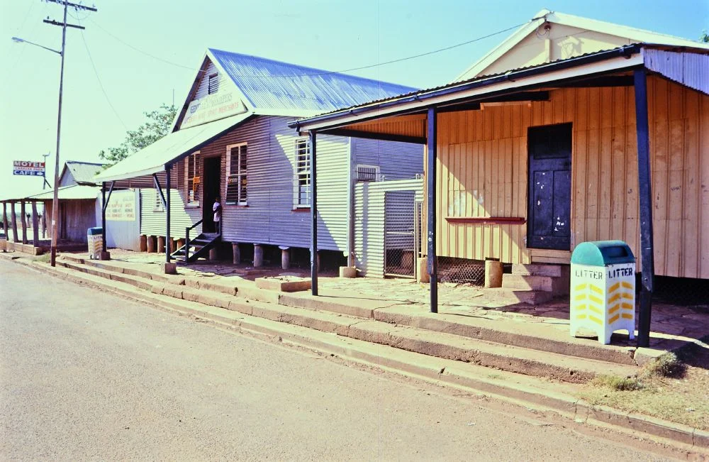
.jpg)
Freckleton's Stores, Camooweal
Before a drover pointed his cattle and his pack horses toward the Northern Territory, he came here first. At the western end of Barkly Street, where the bitumen runs out toward the border, two weathered corrugated-iron stores stand side by side - the Old Store and the Bond Store. Inside, hand-hewn timber shelving still climbs the walls, built to hold sacks of flour and months of provisions. For more than a century this was the practical heart of Camooweal: the place you stocked up before vanishing into country where the next shop might be hundreds of dusty kilometres away. Freckleton's Stores survive as one of the last intact pairs of outback iron stores in Queensland - plain, tough buildings that fed a frontier.
Iron on the Limestone
These are not grand buildings, and that is the point. The Old Store is wrapped in vertically-run corrugated iron over a timber frame, with a simple gabled roof and lean-to skillions, its posts set on bedlogs and its floor joists resting straight on the earth - close enough to the ground that white ants have long been a problem. An awning runs the width of the street front, sheltering a footpath paved with slabs of local unworked limestone, bedded in antbed and edged by a low concrete wall. Beside it, the Bond Store sits up on stumps and steel posts, clad in horizontally-run iron and lined inside with stained timber, its built-in counters and cupboards still in place. Two honest sheds, shaped entirely by climate and use.
A Store Passed Hand to Hand
The story of the allotment is a chain of outback names. The land was granted to Thomas Harding in 1888, in a town only four years old, and changed hands through a succession of Camooweal storekeepers - Frith, then Affleck - before Patrick Synnott acquired the stores in 1911. Trading as Synnott, Murray and Scholes from 1918, the business became the hub where drovers collected the gear and supplies they needed before their long journeys. By the 1940s it even held the Shell and Qantas agencies, knitting the remote town into the new networks of fuel and flight. Around 1950 a former store was moved onto the block and re-erected, becoming a third building that ran as a café and milk bar into the early 1980s.
The Freckleton Name
The stores carry the name of the man who bought the business in 1943: Joseph Freckleton, a tank sinker and teamster who had come originally from South Australia. It is a fitting custodian's name - someone who had himself worked the hard trades of the inland, sinking water tanks and driving teams, before taking over the counter that supplied men like him. Under the Freckleton family the store became an institution, a fixed point in a shifting droving world. The handshake and the long account, extended to families who passed through on the stock routes season after season, were the real currency here. The business finally closed, and its museum with it, in 2009 - the end of well over a century of trade on a single patch of Barkly Street.
What the Pair Remembers
Heritage listing in 1992 recognised the stores for something larger than themselves: they show, plainly and completely, how inland north-west Queensland was settled and supplied. The two buildings complement each other in form and material, surviving together as a now-uncommon pair of corrugated-iron stores that still anchor the Camooweal streetscape. To stand beneath the awning is to feel the rhythm of an older economy - the seasonal arrival of drovers, the loading of months of flour, the careful work of outfitting a journey into emptiness. The cattle and the camel teams are long gone from Barkly Street, but the shelving that held their provisions is still here, waiting in the dim, iron-roofed quiet.
From the Air
Located at 19.92°S, 138.12°E, at the western end of Barkly Street in Camooweal, close to the Georgina River and about 13 km east of the Northern Territory border. From the air the stores read as a cluster of small corrugated-iron roofs at the edge of the town grid on the flat, pale floodplain. Camooweal Airport (YCMW/CML) lies roughly half a nautical mile north-east; the nearest major airfield is Mount Isa Airport (YBMA/ISA), about 165 km east along the Barkly Highway. The highway and the braided Georgina River channels are the clearest navigation features in otherwise featureless country. Best viewed under clear dry-season skies, May–September.
Nearby Stories
- Riversleigh World Heritage Area 74 km away
- Barkly Tableland 77 km away
- George Fisher mine 107 km away
- Lake Moondarra 131 km away
- 1964 Mount Isa Mines strike 165 km away
- Brunette Downs Station 197 km away
- Marqua Station 288 km away
- Tennant Creek 344 km away