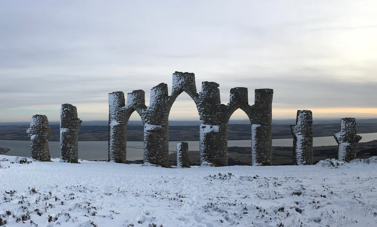

Fyrish Monument
Sir Hector Munro is said to have rolled the stones back down the hill at the end of each working day. His labourers would carry them up again the next morning, and he would pay them for the additional hours. The story may be apocryphal but it captures something essential about the Fyrish Monument: it is a folly built not for vanity but to keep people fed during the Highland Clearances, when the population of Easter Ross was being pushed off the land they had worked for centuries. The folly stands in the shape of the Gate of Negapatam, a port in southern India that Munro had captured for the British in 1781.
The General and the Port
Sir Hector Munro, 8th of Novar, was a Highland laird who made his name in India. A career soldier in the East India Company's armies, he commanded the Indian troops at the Battle of Buxar in 1764 and later served as commander-in-chief at Madras. In 1781, late in his Indian career, he led the siege and capture of Negapatam, a Dutch-held port on the Coromandel Coast, transferring it to British control. The following year, back home in Easter Ross, he ordered the construction of a stone replica of the gatehouse he had taken: three tall arches flanked by smaller arches and topped with obelisks, all in dressed local stone, set on the summit of Fyrish Hill (Cnoc Fyrish in Gaelic) above his Novar estate.
Work for the Cleared
The monument went up in 1782, at a moment when the surrounding parishes were beginning to feel the early waves of what would become the Highland Clearances. Landlords across the Highlands were moving people off arable ground to make way for sheep, and the small tenant farmers and cottars who had worked the land for generations were being forced into towns, into coastal fishing settlements, or onto emigrant ships bound for North America. Munro's response, at least at Fyrish, was to provide paid labour. The folly's purpose was straightforwardly ornamental, a Highland laird's monument to his Indian victory. Its function in the parish economy was more practical: stones to carry, walls to build, weeks of paid work for men and women who would otherwise have had none. The detail about rolling the stones down the hill to extend the labour is local tradition rather than documented fact, but it has the shape of a story people wanted to remember about him, whether or not it happened exactly that way.
The View from the Top
Fyrish Hill rises to 453 metres above sea level - not high by Highland standards, but high enough to dominate the lower country between Alness and Evanton, and high enough to be seen from almost anywhere in the parishes of Kiltearn and Alness. The monument is visible across the Cromarty Firth and far up the Black Isle. From the summit itself the view runs east to the firth and the North Sea, south to Ben Wyvis (1,046 m) and the great snow-streaked massif of the Northern Highlands, and west to the open hill country that fills the interior of Easter Ross. A path to the top starts at a car park northeast of the hill, at Ordnance Survey grid reference NH627715. The walk takes about an hour each way through forestry plantation and onto open moor.
What Endures
Folly is a word that gets applied to monuments like this, and it carries a tone of dismissal that the Fyrish Monument does not quite deserve. The structure is now a Category B listed building - protected under Scottish heritage law as a building of regional importance. It has lasted nearly two and a half centuries through a climate that does not flatter stonework. The east coast of Ross gets wind and rain off the North Sea in serious quantities, and yet the obelisks still stand. The cleared population is gone. Their descendants live in cities across the world. The work the monument provided was a tiny offset against the dispossession that was reshaping the Highlands around it, and reading too much generosity into a Highland laird who built a memorial to his own Indian conquest would be unwise. What remains on the hilltop is more complicated than either villain or hero allows.
From the Air
Located at 57.70 N, 4.34 W on Fyrish Hill (453 m elevation) above Evanton in Easter Ross. The monument is roughly 15 nm north-northeast of Inverness Airport (EGPE), the nearest major ICAO field. The hilltop folly with its arches and obelisks is a recognizable small landmark visible from across the Cromarty Firth. Ben Wyvis (1,046 m) rises to the southwest. Best viewing 2,500-4,000 ft AGL to take in the monument profile against the sky, the firth, and the forested approach from Evanton. Watch for orographic cloud on Ben Wyvis and rapid weather changes off the North Sea.
Nearby Stories
- Lairg 1.4 km away
- Corrieshalloch Gorge 6 km away
- Tomnahurich Cemetery 9.2 km away
- Battle of Tarbat 10 km away
- Speyside Way 14 km away
- North West Highlands Geopark 17 km away
- Helmsdale 17 km away
- Glen Affric 24 km away