The Volcano That Grounded the Sky
Before 1982, no one in aviation worried about volcanoes. Jet engines devoured whatever the atmosphere offered -- rain, hail, birds -- and kept burning. Then Mount Galunggung erupted in West Java, and two Boeing 747s fell silent over the Indian Ocean, their engines choked by ash so fine it passed through weather radar undetected. The volcano did not merely endanger aircraft. It revealed a blind spot in the entire system of flight safety, a gap between geology and aviation that no one had thought to close. Today, nine Volcanic Ash Advisory Centers circle the globe because of what happened above this 2,168-meter stratovolcano in the rice country southeast of Bandung.
Born from Collision
Galunggung rises from the western spine of Java, part of the Sunda Arc -- the long volcanic chain produced where the Australian Plate grinds beneath the Eurasian Plate at roughly seven centimeters per year. This subduction zone has built more than 130 active volcanoes across Sumatra, Java, and the Lesser Sunda Islands, making Indonesia the most volcanically active nation on Earth. Galunggung itself stands 2,168 meters above sea level, about 80 kilometers southeast of the provincial capital Bandung and 20 kilometers northwest of the town of Tasikmalaya. Its summit bears a distinctive horseshoe-shaped crater, the scar of an ancient landslide so massive it scattered debris across the lowlands below, creating a landscape the locals call the Ten Thousand Hills of Tasikmalaya.
Ten Thousand Hills
For decades, geologists puzzled over the hummocky terrain surrounding the volcano's base -- hundreds of small, rounded hills rising from the rice paddies near Tasikmalaya. Early theories suggested they were man-made, heaps of boulders cleared from agricultural land, or perhaps remnants of a catastrophic lahar released when the crater lake burst its rim. Local Sundanese communities built houses atop the hummocks, which offered natural defense against intruders and stood above the mosquitoes and rats of the flooded paddy fields. It was not until the 1980 eruption of Mount St. Helens, half a world away in Washington State, that the answer became clear. The hummocks were debris-avalanche deposits, the scattered remains of a colossal flank collapse. Shattered lava blocks embedded in the hills matched the pattern seen at St. Helens and Mount Shasta. Radiocarbon dating placed the landslide within the last 23,000 years -- recent in geological terms, inevitable in volcanic ones.
The Year the Mountain Woke
Galunggung's first documented eruption came in 1822, when pyroclastic flows and lahars -- fast-moving rivers of volcanic mud -- swept down its flanks and killed 4,011 people. Smaller eruptions followed in 1894 and 1918. Then came 1982. Beginning in April, the volcano entered a prolonged eruptive phase rated VEI 4 on the Volcanic Explosivity Index, hurling columns of ash high into the jet stream. The eruption itself killed 18 people indirectly, through traffic accidents and starvation in displaced communities. But the volcano's most consequential impact unfolded at 37,000 feet. On June 24, British Airways Flight 009, carrying 263 souls from Kuala Lumpur to Perth, flew into the invisible ash cloud at night. All four Rolls-Royce engines flamed out. The 747 glided powerless for 16 minutes, dropping from 37,000 to under 13,000 feet, before the crew managed to restart and land safely in Jakarta.
A Lesson Learned Twice
After Flight 009's emergency landing, Indonesian authorities closed the airspace around Galunggung -- then reopened it days later, treating the incident as a fluke. Nineteen days after the British Airways event, on July 13, a Singapore Airlines 747 with approximately 230 passengers entered the same ash cloud at night. Three of its four engines stopped. The crew descended 2,400 meters before restarting one engine and limping to Jakarta. Only then did the authorities close the airspace permanently and reroute the airways. The double disaster forced a reckoning. Aviation had no protocol for volcanic ash, no detection system, no warning network. Ash clouds are dry, so weather radar -- designed to find moisture -- passes right through them. Within years, the International Civil Aviation Organization established the Volcanic Ash Advisory Center network, a chain of nine monitoring stations that now tracks eruptions worldwide and issues real-time warnings to every aircraft in their sector.
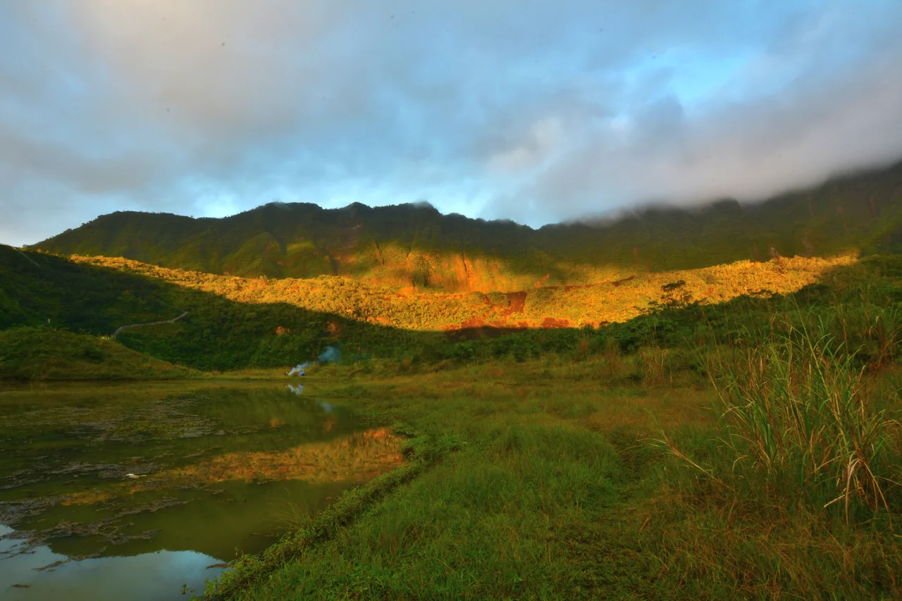
The Quiet Caldera
Galunggung's last confirmed eruption occurred in 1984, and by 2012 -- when its alert status was briefly elevated for the first time in three decades -- the volcano had settled into watchful quiet. The horseshoe crater that marks its ancient collapse now holds a small lake, and the caldera has become a campsite for hikers from Bandung and Tasikmalaya. Terraced rice paddies climb the lower slopes, fed by streams that begin as snowmelt-cold springs inside the volcanic rock. The Ten Thousand Hills remain, their surfaces green with tropical growth, the houses still perched on their crests. Galunggung is not dormant -- it sits atop the same relentless subduction that built it -- but for now, the mountain sleeps. The ash advisories it inspired keep watch while it rests.
From the Air
Mount Galunggung (2,168m / 7,113 ft) is located at 7.26S, 108.08E in West Java, Indonesia. The volcanic cone is visible from cruising altitude on clear days, roughly 80 km southeast of Bandung. Nearby airports include Husein Sastranegara (WICC) in Bandung, Wiriadinata (WICM) in Tasikmalaya, and Nusawiru (WICN) on the south coast. The horseshoe-shaped crater is a distinctive landmark from above, opening to the southeast. Pilots should monitor volcanic ash advisories issued by the Darwin VAAC, which covers Indonesian airspace.
Nearby Stories
- Where the Gods Were Smiling 9.1 km away
- Thirty Villages Under Water 20 km away
- The Island of Flowers and Firing Squads 32 km away
- The Cikubang Bridge: Steel Over the Gorge 32 km away
- LAPAN: Indonesia's Space Agency 47 km away
- The Fortress That Buried Itself 66 km away
- The Admiral's Cave 195 km away
- SIEV X 326 km away