Thirty Villages Under Water
The idea came first in 1963. The water arrived in 2015. Between those dates, the Jatigede Dam consumed decades of planning, waves of protest, court battles, government intimidation, and the slow, grinding displacement of 70,000 people from 30 villages across five districts in Sumedang Regency. When the Cimanuk River finally began filling the reservoir on 31 August 2015 -- thirty days behind the most recent schedule, itself the latest in a long chain of delays -- the rising water covered 4,896 hectares of land where families had farmed, built homes, and buried their dead for generations. Indonesia got a dam. Sumedang lost a landscape.
Half a Century of Planning
The French engineering firm Coyne et Bellier first studied the Cimanuk River in 1963 and identified the Jatigede site as suitable for a major dam. What followed was a timeline that would have been comical if its consequences were not so serious for the people living above the future reservoir. An environmental impact assessment was completed in 1986. A land acquisition study followed in 2003. After decades of planning and protests, the Indonesian government announced firm plans to proceed in 2004. Affected residents challenged the project in court and lost in 2007. Construction on the diversion tunnel began in October 2008 and finished in August 2011. By late 2011, the dam was 60 percent complete. By May 2013, 70 percent. At every stage, resident relocations caused delays. The dam was supposed to impound in early 2015 but slipped to August. The total cost ballooned from an initial estimate of $224 million to approximately $400 million.
The Price of Progress
The controversy was never about whether West Java needed water and power. It was about who would pay the cost. The reservoir flooded 4,896 hectares across five districts and 30 villages, displacing roughly 70,000 people. Residents claimed that compensation for their land was far too low and that government officials had intimidated them into accepting offers during the 1980s, when land acquisition began in earnest. Court challenges failed. President Jokowi's social impact policy for the dam was rejected by affected communities who found it inadequate. The human geography of the Cimanuk valley -- rice paddies, villages, family plots farmed for generations -- disappeared beneath 980 million cubic meters of water. For the displaced, the dam represented not progress but erasure: the deliberate drowning of a way of life to serve the needs of a larger population downstream.
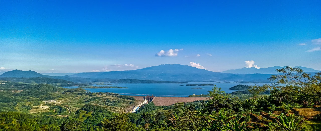
Engineering on a Grand Scale
The numbers are enormous. Jatigede is a rock-fill embankment dam standing 110 meters high and stretching 1,715 meters across the Cimanuk valley. Its body contains 6.7 million cubic meters of fill. The reservoir behind it holds 980 million cubic meters of water -- of which 877 million are classified as active storage -- and covers a surface area of 41.22 square kilometers fed by a catchment basin of 1,462 square kilometers. The spillway, a chute-type structure controlled by four radial gates, can discharge 4,468 cubic meters per second. Water for the power station enters through an intake on the right abutment, travels through a 3,050-meter headrace tunnel, and drives two 55-megawatt Francis turbine-generators with a design hydraulic head of 170 meters. The dam's primary purpose is irrigation -- its reservoir feeds 90,000 hectares of farmland -- but the 110 megawatts of generating capacity serve approximately 500,000 households on the Java grid.
A Clock Made of Silt
Even as the dam was being built, a 2011 study by Indonesia's Ministry of Public Works delivered an uncomfortable forecast: the reservoir would become ineffective within 50 years due to heavy sedimentation of the Cimanuk River. Silt carried down from the highlands would gradually fill the reservoir basin, reducing its storage capacity and eventually rendering the entire project useless. The response involved a coalition of government agencies -- the Ministry of Public Works, the Ministry of Forestry, the West Java provincial government, and local regency authorities -- committed to conservation activities in the Cimanuk watershed. A cekdam, a levee designed to prevent the river from widening and accelerating erosion, would be constructed in the upper reservoir area. Whether these measures can extend the dam's useful life significantly remains an open question. From the air, the reservoir stretches across the Sumedang landscape like a blue mirror set among green hills, 19 kilometers east of the town of Sumedang. It looks permanent. The sediment building on its floor suggests otherwise.
From the Air
Located at 6.86°S, 108.09°E in Sumedang Regency, West Java, Indonesia, approximately 19 km east of the town of Sumedang. The dam and reservoir are clearly visible from altitude -- a 41 square kilometer body of water set in hilly terrain along the Cimanuk River valley. The 1,715-meter-long dam wall is oriented across the valley and is distinguishable at moderate zoom. Nearest significant airport is Husein Sastranegara International Airport (WICC) in Bandung, approximately 50 km to the west-southwest. Kertajati International Airport (WIIK) is approximately 40 km to the northeast. Best viewed at 8,000-15,000 ft for the full reservoir extent and surrounding terrain.
Nearby Stories
- The Glide Over Java 6.4 km away
- Where the Gods Were Smiling 13 km away
- The Cikubang Bridge: Steel Over the Gorge 24 km away
- Battle of Kalijati 52 km away
- Rawagede Massacre 58 km away
- The Island of Flowers and Firing Squads 63 km away
- The Fortress That Buried Itself 99 km away
- The Islands That Vanished from Sight 218 km away