Gooi
In 1972 a thousand-year-old farmer's cooperative finally closed its books. The Erfgooiers — literally the inheritors of the Gooi — had asserted their right to hold the heath and the woods in common since at least the year 1300. Lords had tried to break the arrangement. Counts had bought and resold it. Queens and bishops had argued over who governed which strip of sand. The Erfgooiers outlasted them all. They survived feudalism, the Reformation, the French invasions, the industrial revolution, two world wars. They did not survive the post-war housing boom.
The Hill That Is Not a Hill
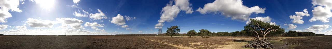
Het Gooi rises to a magnificent 36.4 meters at the Tafelberg, halfway between Blaricum and Huizen. In any other country that would be nothing. In the Netherlands it is a landmark, the highest point for many kilometers in any direction. The Gooi sits on the northernmost knob of the Utrecht Hill Ridge — a glacial push moraine left by ice that stopped here during the penultimate ice age. The sand drains. The peat bogs and fenlands that once encircled it had to be drained too before the region could become part of mainland Holland. For most of human history that natural moat made the Gooi an island, and on that island people had been living since the Bronze Age.
The Hilversum Culture
Three to four thousand years ago, a people lived here whose pottery archaeologists still pull out of the heath. The Hilversum culture, named for the town, dates from roughly 1800 to 1200 BCE — the early and middle Bronze Age. Their urns are cask-shaped and thick-walled, decorated at the rim with the marks of fingertips and fingernails pressed into wet clay. The style resembles pottery from the Wessex culture in southern Britain, and the prevailing theory is that the makers migrated from there. They spoke a now-vanished Indo-European language unrelated to modern Dutch. They buried their dead in barrows still visible on the Bussumerheide and Westerheide today, three- and four-thousand-year-old mounds that walkers cross without realising. A few of the urns are on display at the Hofland Geological Museum beside the St John's Cemetery in Laren — the same churchyard whose 1085 chapel founded the medieval pilgrimage that put the Gooi on the religious map of Holland.
The Convent in Germany That Owned It
From 968 to 1806 — eight hundred and thirty-eight years — the lordship over the Gooi was technically held by a convent of noblewomen in Hoog-Elten, in what is now Germany. Count Wichmann of Ghent founded the convent and handed over the rights. The convent collected its dues and stayed mostly hands-off, which is one reason the Erfgooiers commons could form around 1300 without anyone in particular stopping it. In 1285 Count Floris V of Holland bought the heerlijkheid rights from the convent, which is the moment the area became formally part of the County of Holland. Disputes with the Bishopric of Utrecht followed, lasting centuries. Through all of it the local farmers held their pastures and woods as a commons under their own rules, and called themselves the Erfgooiers, and elected their own officers, and refused to die quietly until 1972.
Sand for Amsterdam
Starting around 1500 and peaking in the seventeenth century, Amsterdam ate the Gooi. The expanding city needed fill — sand to raise neighborhoods above the waterline, sand for foundations, sand for new canals — and the Gooi had centuries of it. Quarries opened. Canals were dug from 's-Graveland and Naarden and Bussum to ferry sand westward by barge. The same canals that hauled sand out brought passenger boats in, and the area became reachable in a few hours from Amsterdam. The transformation accelerated when the Amsterdam-Amersfoort railway opened in 1874. Hilversum and Bussum grew first. The tram line of 1892 linked Laren, Blaricum, and Huizen and reshaped them within a generation. By the time the motorways arrived in the 1950s, the Gooi was no longer a sandy hinterland. It was a chain of villa villages strung along train and tram lines for the wealthy of Amsterdam and Utrecht.
Radio, Television, and the Disappearing Dialect
In 1918 a radio and transmitter factory called the Nederlandse Seintoestellen Fabriek opened in Hilversum. From it grew the entire Dutch broadcasting system — AVRO, VARA, KRO, NCRV, and the rest. The first Dutch television broadcast went out from Bussum. The Gooi became the country's media spine, and the celebrities followed the studios into the leafy villas. The original local dialect, called Goois — a Dutch Low Saxon tongue spoken in Bussum, Laren, and Blaricum — survived all the centuries of foreign lordship and sand quarrying and railway tourism. It did not survive the broadcasters. By the late twentieth century it had nearly vanished, replaced by the soft American-style r of newcomers from Amsterdam. The Gooi gave the country its voice and lost its own.
What the Commons Left Behind
Drive the A1 through the Gooi today and you can miss it. The villages stay hidden behind their wooded margins, an architectural decision the locals made deliberately and which the Goois Natuurreservaat foundation now preserves. The Naardermeer — the oldest nature reserve in the Netherlands, founded in 1906 — protects a wetland the developers wanted to drain. The Natuurbrug Zanderij Crailo, the longest wildlife crossing in the world, stitches the heaths together over the highway. The burial mounds are still there. The brink — the village green — still anchors Laren and Blaricum, the only two villages in North Holland that kept theirs. The Erfgooiers are gone. The land they fought for is not.
From the Air
Centered at 52.23N, 5.22E. Recommended viewing altitude 2,500-4,500 feet. Visual landmarks: the dry sandy Gooi ridge stands distinctly above the surrounding polders, with heath and forest visible as patches of brown and dark green. The Naarden star fort is unmistakable from above. Hilversum's compact urban core sits in the center. The Tafelberg, the highest point, is 36.4 m. Nearby airports: Hilversum Airport (EHHV) sits within the region. Lelystad (EHLE) 25 km northeast. Schiphol (EHAM) 25 km west — its TMA shapes overflight at this altitude.
Nearby Stories
- Ermelo, Netherlands 0.8 km away
- Rotterdam-The Hague Metropolitan Region 2.5 km away
- Keukenhof 3.1 km away
- Wetlands International 3.7 km away
- Dutch Language 7.5 km away
- Westfries Museum 9.3 km away
- Wind Power in the Netherlands 11 km away
- IJssel 15 km away