Großer Knechtsand
The deal looked reasonable on paper. The people of Heligoland wanted to go home; their island had been a target range since the war, and the British had no immediate plans to give it back. Chancellor Konrad Adenauer offered the Royal Air Force an alternative: a low, broad sandbank in the Elbe-Weser Triangle called Großer Knechtsand. It was uninhabited. The water around it was shallow. Practice bombs - high explosive and incendiary - could fall there without hurting anyone. Beginning in 1952 the RAF accepted, Heligoland was returned, and for five years British aircraft droned out across the German Bight to drop ordnance on a sandbar that, the planners had assured everyone, was empty. Except it wasn't.
What Lived There
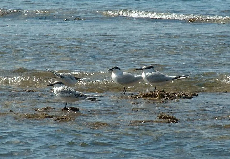
Großer Knechtsand sits between two German islands - Mellum to the southwest and Neuwerk to the northeast - in the eastern fringe of the Lower Saxon Wadden Sea. Most of the time, most of it is underwater. But a central core called the Hoher Knechtsand - the high sand - rises above the high water mark, a flat patch about 2.5 kilometers long and up to 1.6 kilometers wide. It used to be an island. It is, year after year, one of the most important molting grounds in Europe for the common shelduck, where adult birds gather in their thousands to shed and regrow their flight feathers during a period of weeks when they cannot fly at all. The sandbank also hosts one of the largest and longest-lived breeding colonies of Sandwich terns in the region, along with eider ducks and common seals hauled out by the tide channels. None of which the bombing plans accounted for.
The Reaction
By the mid-1950s a new word had entered postwar German public life: Umweltschutz, environmental protection. Ornithologists and naturalists who knew what Großer Knechtsand actually was began to make noise. So did fishermen, who watched the bombs fall and the shelducks scatter and the tern chicks die in their colonies. The protests built. In 1957, when the British contract came up for renewal, it was not renewed. The bombing stopped. That same year, in what amounted to an immediate course correction, the Federal Republic designated the area Germany's largest nature reserve. Less than thirty years after that, in 1986, Großer Knechtsand became part of the strict 'quiet zone' core of the Lower Saxon Wadden Sea National Park, the most protected category in the German conservation system.
A Sandbank's Geography
Standing here, if you somehow could - it is closed to all but the most carefully supervised research visits - you would find a place defined entirely by water. To the east lie the mudflats of Spiekaer Barre. North and south, deep tidal channels called Priele - Westertill, Ostertill, Robins Balje - cut around the high sand twice a day on the rising and falling tide. The nearest mainland village is Berensch, about eleven kilometers east across open water in the Land Wursten on the borough of Cuxhaven. The whole place is shaped by the tide rather than by anyone living on it. Two kilometers northwest lies a smaller cousin, the Kleine Knechtsande, an even lower set of sandbars that the sea covers most of the time. Together they make up some of the most productive seabird habitat on the German coast.
The Birds That Stopped a War Range
There is a particular weight to the Großer Knechtsand story that gets lost if you just file it under 'environmental history.' The decade after 1945 was supposed to be a moment when nothing could compete with rebuilding, military priorities, and the alliance politics of the new Cold War. The British wanted a target range. The Germans wanted Heligoland back. The trade made sense to almost every decision-maker involved. And then it was undone, in only five years, by people who counted shelducks and tern eggs and made the moral and political case that this sandbank mattered for what already lived on it. It was an early German environmental victory - early enough that the legal framework to protect places like this barely existed yet, and was largely built afterward in response to what had happened here. The bombs are long since cleared. The shelducks still come.
From the Air
Großer Knechtsand lies at 53.83°N, 8.36°E in the Elbe-Weser Triangle of the German Bight, between the islands of Mellum (16 km southwest) and Neuwerk (11 km northeast). The sandbank is largely submerged at high tide; at low tide the central Hoher Knechtsand emerges as a flat sand plateau roughly 2.5 km long. The nearest mainland reference is Cuxhaven (Nordholz-Cuxhaven ETMN to the east), with Bremerhaven roughly 20 nm south-southwest. The sandbank is a strict 'quiet zone' of the Lower Saxon Wadden Sea National Park - viewing should be from altitude only, ideally 1,500-2,500 feet to see the tidal channel network (Westertill, Ostertill, Robins Balje) and the surrounding mudflats. Approaches and overflights must respect the wildlife sanctuary status of this area.
Nearby Stories
- German Trawler V 1101 Preussen 6.6 km away
- JadeWeserPort 8.4 km away
- Taktisches Luftwaffengeschwader 71 "Richthofen" 8.5 km away
- SM UC-45 9.9 km away
- HMS Ariel (1911) 13 km away
- Wöbbelin Concentration Camp 181 km away
- Ludwigslust Palace 188 km away
- Lilleø 194 km away