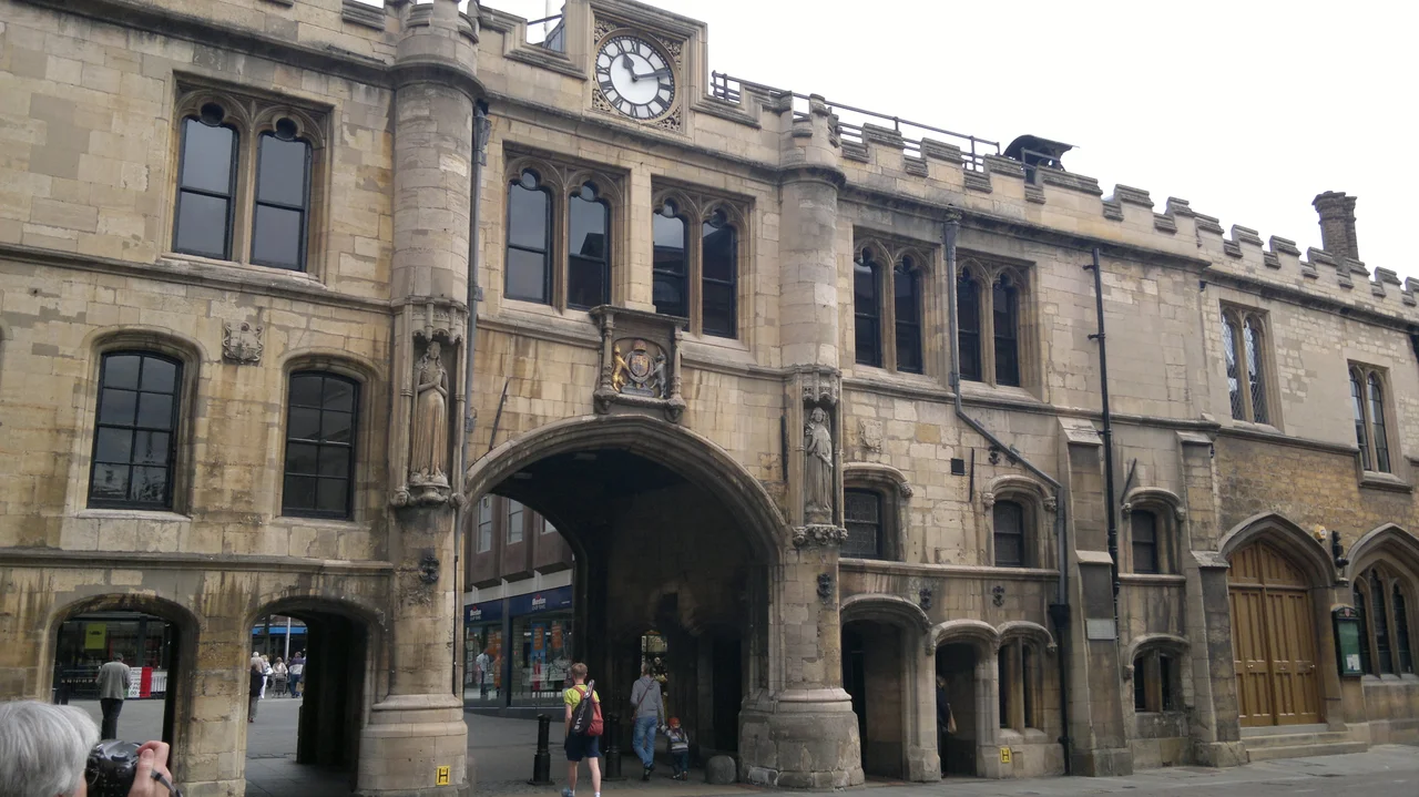

Guildhall and Stonebow, Lincoln
Most English cities have lost their gates. London ditched its Roman walls in stages from the Restoration onward; York is exceptional for keeping its medieval bars; almost everywhere else, the great stone arches that once controlled who came in and out of town were taken down in the 19th century to widen the road for carriages. Lincoln did not. The Stonebow - the southern gateway through which travellers entering the city from London once arrived - is still there, still spanning the High Street, still doing the same job for pedestrians that it has done for at least eight hundred years. And up the staircase above the arch, the Lincoln City Council still meets in the same chamber that medieval guild masters once met in, beneath the same hand-carved corbels.
The Name and the Wall
Lincoln in Roman times was a colonia - a senior city for retired legionaries - laid out on top of the limestone ridge with a lower town extending south to the River Witham. The southern gate of that lower Roman town stood roughly where the Stonebow stands today. The name itself is Norse: stennibogi, meaning stone arch, a word the Vikings brought when they settled the Five Boroughs of the Danelaw in the late 9th century. They saw the surviving Roman gateway, called it a stennibogi, and the name stuck through Norman, Plantagenet, Tudor, and modern times. When the Lincoln architect W. A. Nicholson made alterations to the east end of the building around 1840, he discovered that the original Roman wall of the lower city was still standing fifteen feet high to the north of the Stonebow - which means the medieval gateway was probably a barbican, built forward of the older Roman arch as an outer line of defence.
Rebuilt After a False Start
There has been a guildhall on this spot since 1237, originally above an earlier gateway in the same alignment. Lincoln's medieval guilds, who effectively ran the city's commercial life, used the upper room as their meeting hall and council chamber. The earlier guildhall and gate were demolished in the late 14th century, with the intention of rebuilding immediately. The intention foundered on the kind of mundane problem that affects all civic projects: the money ran out. For nearly a century and a half the gateway stood as a building site or stop-gap, until enough resources had accumulated to finish the job. The present Stonebow was finally completed around 1520, in the late Perpendicular Tudor style, of pale local limestone with crenellated parapets and decorative niches containing carved figures on the south front. A tablet bears the arms of James I, who must have been celebrated in some commemorative addition during his reign, and above that two two-light mullioned windows and a stepped gable containing a clock.
The Council Chamber Above
The Guildhall itself sits on the first floor over the central arch - a single long timbered chamber with a medieval roof of crown-post construction supported on stone corbels carved with grotesque human and animal faces, several of which date from the building's 16th-century completion. The Mayor of Lincoln still presides from a canopied chair at the head of the room. The civic regalia displayed at the east end include some of the oldest in any English provincial city: the great mace, the swords of state, the chains of office. A 14th-century bell - older than the present building - still hangs in the gable above and is rung to summon councillors to their meetings, as it has been for around seven centuries. The room won a Visit England "Best Story Told Award" in 2019, recognition that meant something to the council members who use the chamber as their weekly workplace - the medieval setting is not theatre but daily routine, the way the room has always been used.
The 1840s Mayor's Parlour
Around 1840 the city demolished an old prison that had stood at the east end of the Stonebow and asked Nicholson to design a replacement wing in matching Tudor style. That wing, completed about 1844, now contains the Mayor's Parlour and the display of civic regalia. It is a careful piece of Victorian work - pointed mullioned windows, embattled parapet, integrated entirely with the older building - and most visitors do not realise the section is three centuries newer than the central gateway. In the 1885 to 1890 alterations, the architect J. L. Pearson, better known for High Anglican churches, added another passageway arch on the west side and tucked small shop units underneath, a minor commercial intervention that does not noticeably interfere with the medieval reading of the whole.
Why It Still Works
Most surviving English city gates are now isolated relics - bypassed by traffic, fenced off as monuments, charged for admission. The Stonebow is none of those things. The High Street still runs underneath the central arch. The Lincoln City Council still meets in the upper chamber. Shops still trade from the spaces underneath. The mayor still steps out onto the balcony on civic occasions. The whole building is doing today what it was designed for in 1520, with the same ceremonial function on top and the same commercial flow below. The Roman wall is still there too, hidden behind the later masonry but holding up Nicholson's wing on its old foundations. A pedestrian walking up the High Street from the south is following a route that has been the main approach to Lincoln since legionaries from Italy and Gaul marched up the same alignment to deliver their pay to the same market. The city has changed almost everything around the route. The route has not changed.
From the Air
The Guildhall and Stonebow stands at 53.2292°N, 0.5405°W on Lincoln High Street, in the lower town below the cathedral and castle. From the air the building appears as a stone Tudor gateway spanning the central pedestrianised section of the High Street, immediately north of the Brayford Pool waterfront. Lincoln Cathedral and Castle, on the limestone ridge about a quarter-mile north, dominate the visual approach to the city. Recommended viewing altitude is 1,500 to 3,000 feet AGL. The line of Ermine Street - the Roman road from London to York that the Stonebow originally guarded - runs north-south through the modern High Street and is visible as a long straight cut through the centre of the city. Nearby airfields include RAF Waddington (EGXW) about five nautical miles south, RAF Scampton (EGXP) seven nautical miles north-northwest, and Humberside Airport (EGNJ) twenty-six nautical miles north-northeast. The Witham valley provides a clean east-west visual axis through the lower town.
Nearby Stories
- Louth Navigation 2.9 km away
- Major Oak 3.6 km away
- Grantham Rail Accident 8 km away
- South Yorkshire Aircraft Museum 9.3 km away
- Gotham, Nottinghamshire 11 km away
- Alford Windmill 16 km away
- RAF Binbrook 21 km away
- Wisbech 29 km away