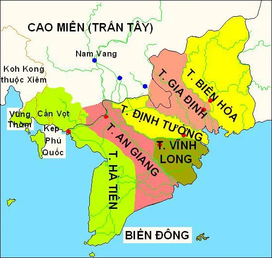

Hà Tiên Province
Pontiamas. Ponteamass. Phutthaimat. Bantay-mas. Pontiamasse. Po-taimat. For most of the eighteenth century, European cartographers could not agree on what to call the port at the western edge of the Mekong Delta — and most of them were labelling the wrong town anyway, since those variants all descend from Banteay Meas, a Khmer settlement inland. The confusion suits the subject. Hà Tiên was founded by a Chinese exile on Cambodian ground, chartered by a Khmer king, protected by Vietnamese lords, and destroyed by a Siamese one. It never fit the categories available to it, and the mapmakers, in their scrambled way, were being honest about that.
The Man Who Would Not Kneel
Mạc Cửu was born in 1655 in Leizhou, in Guangdong, into a China that was coming apart. The Ming dynasty was collapsing; the Qing were consolidating; and like a great many southern Chinese merchants of his generation, he decided he would rather leave than submit to the new order. He went south to Cambodia, where the king granted him the Khmer title Okna and a commission to develop the coast. He made money — a gambling house, then trade — and money brought people. Chinese and Vietnamese settlers accumulated around him, and a string of villages grew up along the shore and out on Phú Quốc. The territory the Khmer called Mang Khảm was becoming something else, and it had no obvious name for what it was becoming.
1708, and the Choosing of a Patron
A merchant principality on a contested coast has to shelter under somebody. In 1708 Mạc Cửu sent tribute to the Nguyễn lord Nguyễn Phúc Chu and was accepted as a vassal; the coast became the Hà Tiên Protectorate and he became its first governor, with the military title tổng binh and a marquessate to go with it. The lord also gave the place its Vietnamese name. Hà Tiên means something close to river immortal — a spirit of the water — and it replaced Mang Khảm on the paperwork if not immediately in local speech. Mạc Cửu died on 18 July 1735. His eldest son, Mạc Thiên Tứ, was confirmed as successor by the next Nguyễn lord, and the arrangement held: a Chinese family governing a Khmer-founded coast in the name of a Vietnamese court.
A Poetry Society on the Frontier
What happened next is the part nobody expects from a frontier port. In 1736 a scholar named Trần Trí Khải founded the Chiêu Anh Các in Hà Tiên — a hall to honour Confucius and to gather literary talent — with Mạc Thiên Tứ as its patron and presiding figure. The following year it published Hà Tiên thập vịnh, the Ten Songs of Hà Tiên: 320 poems in Chinese characters by thirty-two authors, all of them circling ten scenic views around the town. Poets came from across Vietnam and from China because the society had a reputation. Under Thiên Tứ the port grew into the best-known harbour on the Gulf of Siam, in the decades before Saigon and Bangkok existed in any recognisable form. He built schools and fortifications, and he let the French missionary Pierre Pigneau de Behaine preach without interference.
The Coast That Changed Hands
In 1757 Mạc Thiên Tứ backed an exiled Cambodian prince, Nặc Tôn, and put him on the throne as Outey II. The new king paid for the help in land, ceding five prefectures — Hương Úc, Cần Bột, Trực Sâm, Sài Mạt and Linh Quỳnh — which the Nguyễn lord Võ accepted and left under Hà Tiên's administration. Read those names on a modern map and the scale of the transaction becomes clear: they are Sihanoukville, Kampot, Chhouk, Banteay Meas and Kiri Vong. A single dynastic favour redrew a coastline that two countries still argue about. The reckoning came in 1771, when Thiên Tứ backed the wrong claimant in Siam and King Taksin invaded and occupied Hà Tiên. Thiên Tứ fled, briefly returned, and finally took refuge in Siam, where he died in a Thonburi prison in 1780.
The Province That Kept Dissolving
The Nguyễn dynasty abolished the Mạc family's hereditary title in 1832 and made Hà Tiên one of the Six Provinces of Southern Vietnam. After that it was more erased than governed. The French absorbed it into Cochinchina. In 1950 it was merged with Long Châu Hậu into a new Long Châu Hà; in 1954 that was broken up again into Hà Tiên, Châu Đốc and Long Xuyên; and on 22 October 1956 Hà Tiên province was merged with Rạch Giá province to create Kiên Giang, leaving Hà Tiên and Phú Quốc as mere districts of it. Kiên Giang itself lasted until 2025, when it was folded into An Giang. Every few decades someone redraws the line. The port, the lagoon and the tombs on the hillside stay where they are.
From the Air
The former province's capital sat at 10.383°N, 104.483°E, on the Gulf of Thailand where Vietnam's coast meets Cambodia's. At its eighteenth-century greatest extent, Hà Tiên's administration reached northwest along the whole Cambodian shoreline to what is now Sihanoukville — a coast best appreciated from 8,000–10,000 ft heading northwest, with the Gulf on your left and the karst-studded delta plain on your right. Nearest airports: Phú Quốc International (VVPQ) about 60 km southwest, Rạch Giá (VVRG) about 75 km southeast. Dry-season visibility from December to March is far better than the hazy, storm-prone wet months.
Nearby Stories
- An Giang province 7.1 km away
- Bokor National Park 16 km away
- Phú Quốc Prison 18 km away
- Dâmrei Mountains 18 km away
- Kiên Giang province 22 km away
- Takéo province 36 km away
- Tonle Sap–Mekong Peat Swamp Forests 50 km away
- Battle of Prek Klok I 145 km away